You are here: Home > Network List > PS - Pacific21 Stations List
> Station MCSJ Minamitorishima, Marcus Island, Japan > Earthquake Result Viewer
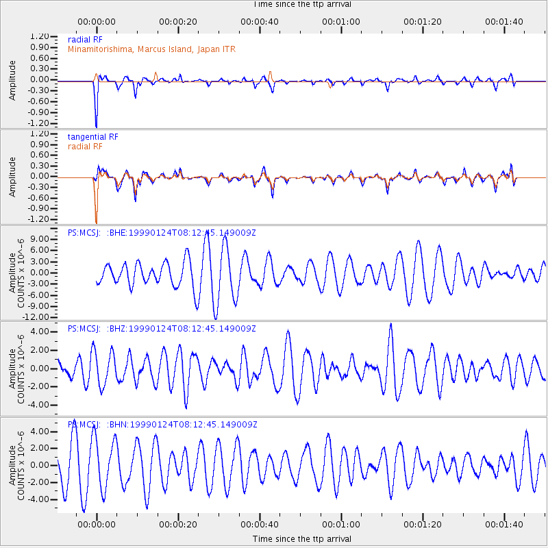
MCSJ Minamitorishima, Marcus Island, Japan - Earthquake Result Viewer
*The percent match for this event was below the threshold and hence no stack was calculated.
| Earthquake location: |
Mid-Indian Ridge |
| Earthquake latitude/longitude: |
-26.5/74.5 |
| Earthquake time(UTC): |
1999/01/24 (024) 08:00:08 GMT |
| Earthquake Depth: |
10 km |
| Earthquake Magnitude: |
6.0 MB, 6.3 MS, 6.3 MW, 6.3 ME |
| Earthquake Catalog/Contributor: |
WHDF/NEIC |
|
| Network: |
PS Pacific21 |
| Station: |
MCSJ Minamitorishima, Marcus Island, Japan |
| Lat/Lon: |
24.29 N/153.98 E |
| Elevation: |
10 m |
|
| Distance: |
91.8 deg |
| Az: |
63.857 deg |
| Baz: |
241.868 deg |
| Ray Param: |
$rayparam |
*The percent match for this event was below the threshold and hence was not used in the summary stack. |
|
| Radial Match: |
61.820312 % |
| Radial Bump: |
254 |
| Transverse Match: |
42.052753 % |
| Transverse Bump: |
309 |
| SOD ConfigId: |
4480 |
| Insert Time: |
2010-02-27 03:04:24.705 +0000 |
| GWidth: |
2.5 |
| Max Bumps: |
400 |
| Tol: |
0.001 |
|
Signal To Noise
| Channel | StoN | STA | LTA |
| PS:MCSJ: :BHZ:19990124T08:12:45.149009Z | 1.2631885 | 1.8581868E-6 | 1.4710289E-6 |
| PS:MCSJ: :BHN:19990124T08:12:45.149009Z | 1.3680896 | 2.993885E-6 | 2.188369E-6 |
| PS:MCSJ: :BHE:19990124T08:12:45.149009Z | 2.4142067 | 7.630718E-6 | 3.1607558E-6 |
| Arrivals |
| Ps | |
| PpPs | |
| PsPs/PpSs | |


