You are here: Home > Network List > PS - Pacific21 Stations List
> Station MCSJ Minamitorishima, Marcus Island, Japan > Earthquake Result Viewer
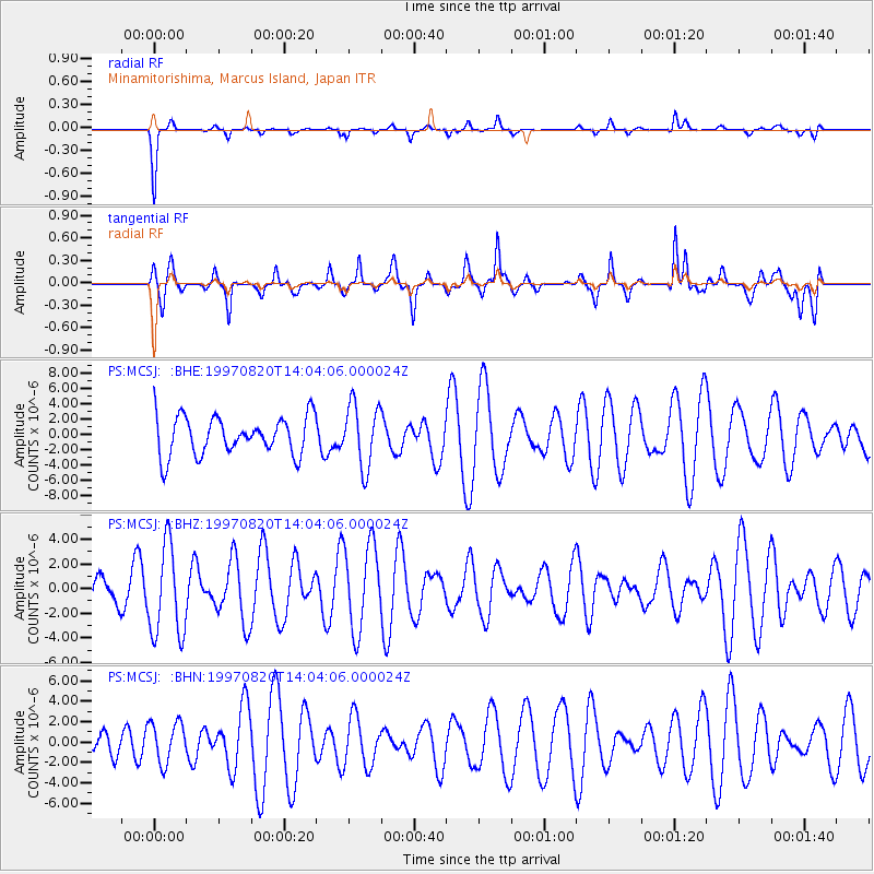
MCSJ Minamitorishima, Marcus Island, Japan - Earthquake Result Viewer
*The percent match for this event was below the threshold and hence no stack was calculated.
| Earthquake location: |
Mid-Indian Ridge |
| Earthquake latitude/longitude: |
-41.7/80.1 |
| Earthquake time(UTC): |
1997/08/20 (232) 13:51:16 GMT |
| Earthquake Depth: |
10 km |
| Earthquake Magnitude: |
5.6 MB, 6.4 MS, 6.5 UNKNOWN, 6.4 MW |
| Earthquake Catalog/Contributor: |
WHDF/NEIC |
|
| Network: |
PS Pacific21 |
| Station: |
MCSJ Minamitorishima, Marcus Island, Japan |
| Lat/Lon: |
24.29 N/153.98 E |
| Elevation: |
10 m |
|
| Distance: |
94.7 deg |
| Az: |
61.566 deg |
| Baz: |
226.177 deg |
| Ray Param: |
$rayparam |
*The percent match for this event was below the threshold and hence was not used in the summary stack. |
|
| Radial Match: |
83.71356 % |
| Radial Bump: |
195 |
| Transverse Match: |
61.482136 % |
| Transverse Bump: |
383 |
| SOD ConfigId: |
4480 |
| Insert Time: |
2010-02-27 03:04:33.086 +0000 |
| GWidth: |
2.5 |
| Max Bumps: |
400 |
| Tol: |
0.001 |
|
Signal To Noise
| Channel | StoN | STA | LTA |
| PS:MCSJ: :BHZ:19970820T14:04:06.000024Z | 3.1873472 | 3.6967988E-6 | 1.1598356E-6 |
| PS:MCSJ: :BHN:19970820T14:04:06.000024Z | 0.98792166 | 2.0019422E-6 | 2.0264179E-6 |
| PS:MCSJ: :BHE:19970820T14:04:06.000024Z | 1.6398011 | 4.1063845E-6 | 2.5041966E-6 |
| Arrivals |
| Ps | |
| PpPs | |
| PsPs/PpSs | |


