You are here: Home > Network List > PS - Pacific21 Stations List
> Station MCSJ Minamitorishima, Marcus Island, Japan > Earthquake Result Viewer
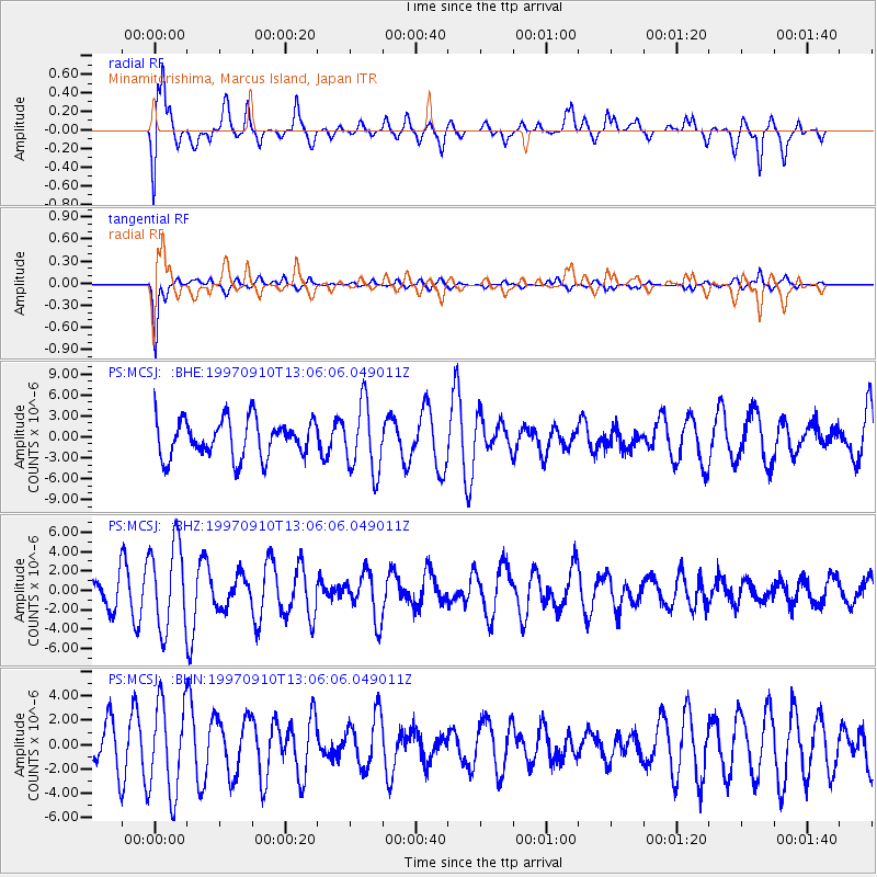
MCSJ Minamitorishima, Marcus Island, Japan - Earthquake Result Viewer
*The percent match for this event was below the threshold and hence no stack was calculated.
| Earthquake location: |
Tonga Islands |
| Earthquake latitude/longitude: |
-21.3/-174.4 |
| Earthquake time(UTC): |
1997/09/10 (253) 12:57:07 GMT |
| Earthquake Depth: |
10 km |
| Earthquake Magnitude: |
5.7 MB, 6.1 MS, 6.1 UNKNOWN, 5.9 MW |
| Earthquake Catalog/Contributor: |
WHDF/NEIC |
|
| Network: |
PS Pacific21 |
| Station: |
MCSJ Minamitorishima, Marcus Island, Japan |
| Lat/Lon: |
24.29 N/153.98 E |
| Elevation: |
10 m |
|
| Distance: |
54.8 deg |
| Az: |
324.154 deg |
| Baz: |
143.255 deg |
| Ray Param: |
$rayparam |
*The percent match for this event was below the threshold and hence was not used in the summary stack. |
|
| Radial Match: |
60.833466 % |
| Radial Bump: |
400 |
| Transverse Match: |
82.411835 % |
| Transverse Bump: |
269 |
| SOD ConfigId: |
4480 |
| Insert Time: |
2010-02-27 03:04:37.591 +0000 |
| GWidth: |
2.5 |
| Max Bumps: |
400 |
| Tol: |
0.001 |
|
Signal To Noise
| Channel | StoN | STA | LTA |
| PS:MCSJ: :BHZ:19970910T13:06:06.049011Z | 3.239817 | 4.4355293E-6 | 1.369068E-6 |
| PS:MCSJ: :BHN:19970910T13:06:06.049011Z | 1.7460946 | 3.7628354E-6 | 2.1550009E-6 |
| PS:MCSJ: :BHE:19970910T13:06:06.049011Z | 1.8283703 | 4.899416E-6 | 2.6796629E-6 |
| Arrivals |
| Ps | |
| PpPs | |
| PsPs/PpSs | |


