You are here: Home > Network List > PS - Pacific21 Stations List
> Station MCSJ Minamitorishima, Marcus Island, Japan > Earthquake Result Viewer
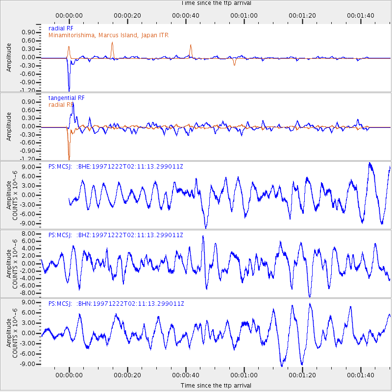
MCSJ Minamitorishima, Marcus Island, Japan - Earthquake Result Viewer
*The percent match for this event was below the threshold and hence no stack was calculated.
| Earthquake location: |
Eastern New Guinea Reg., P.N.G. |
| Earthquake latitude/longitude: |
-5.5/147.9 |
| Earthquake time(UTC): |
1997/12/22 (356) 02:05:50 GMT |
| Earthquake Depth: |
179 km |
| Earthquake Magnitude: |
6.3 MB, 6.7 MS, 7.1 UNKNOWN, 7.0 ME |
| Earthquake Catalog/Contributor: |
WHDF/NEIC |
|
| Network: |
PS Pacific21 |
| Station: |
MCSJ Minamitorishima, Marcus Island, Japan |
| Lat/Lon: |
24.29 N/153.98 E |
| Elevation: |
10 m |
|
| Distance: |
30.2 deg |
| Az: |
11.135 deg |
| Baz: |
192.163 deg |
| Ray Param: |
$rayparam |
*The percent match for this event was below the threshold and hence was not used in the summary stack. |
|
| Radial Match: |
86.45544 % |
| Radial Bump: |
273 |
| Transverse Match: |
59.490215 % |
| Transverse Bump: |
366 |
| SOD ConfigId: |
4480 |
| Insert Time: |
2010-02-27 03:04:51.031 +0000 |
| GWidth: |
2.5 |
| Max Bumps: |
400 |
| Tol: |
0.001 |
|
Signal To Noise
| Channel | StoN | STA | LTA |
| PS:MCSJ: :BHZ:19971222T02:11:13.299011Z | 2.993269 | 3.691759E-6 | 1.2333536E-6 |
| PS:MCSJ: :BHN:19971222T02:11:13.299011Z | 2.2022643 | 2.5287243E-6 | 1.1482383E-6 |
| PS:MCSJ: :BHE:19971222T02:11:13.299011Z | 1.2868232 | 2.9438702E-6 | 2.2877039E-6 |
| Arrivals |
| Ps | |
| PpPs | |
| PsPs/PpSs | |


