You are here: Home > Network List > PS - Pacific21 Stations List
> Station MCSJ Minamitorishima, Marcus Island, Japan > Earthquake Result Viewer
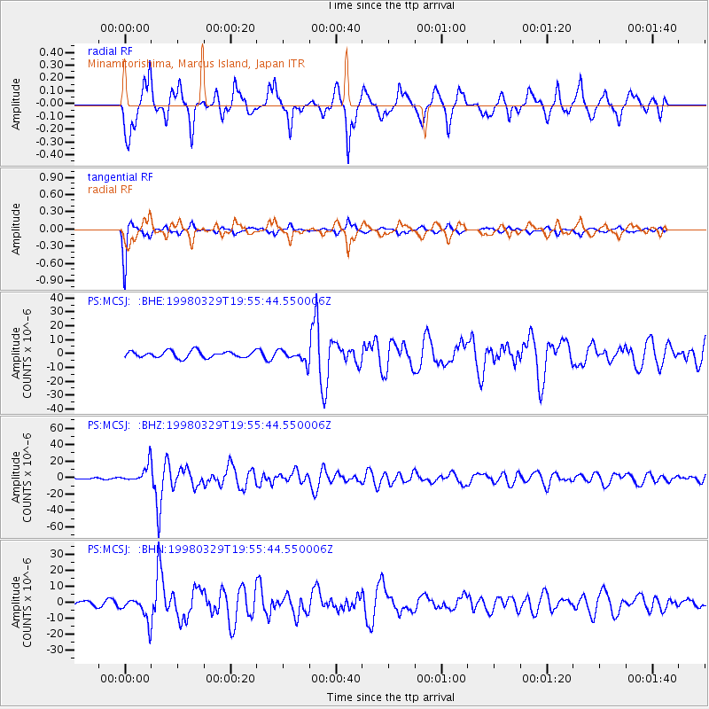
MCSJ Minamitorishima, Marcus Island, Japan - Earthquake Result Viewer
*The percent match for this event was below the threshold and hence no stack was calculated.
| Earthquake location: |
Fiji Islands Region |
| Earthquake latitude/longitude: |
-17.6/-179.1 |
| Earthquake time(UTC): |
1998/03/29 (088) 19:48:16 GMT |
| Earthquake Depth: |
537 km |
| Earthquake Magnitude: |
6.5 MB, 7.2 UNKNOWN, 7.1 MW |
| Earthquake Catalog/Contributor: |
WHDF/NEIC |
|
| Network: |
PS Pacific21 |
| Station: |
MCSJ Minamitorishima, Marcus Island, Japan |
| Lat/Lon: |
24.29 N/153.98 E |
| Elevation: |
10 m |
|
| Distance: |
49.2 deg |
| Az: |
326.906 deg |
| Baz: |
145.19 deg |
| Ray Param: |
$rayparam |
*The percent match for this event was below the threshold and hence was not used in the summary stack. |
|
| Radial Match: |
77.98377 % |
| Radial Bump: |
400 |
| Transverse Match: |
94.11415 % |
| Transverse Bump: |
235 |
| SOD ConfigId: |
4480 |
| Insert Time: |
2010-02-27 03:04:59.960 +0000 |
| GWidth: |
2.5 |
| Max Bumps: |
400 |
| Tol: |
0.001 |
|
Signal To Noise
| Channel | StoN | STA | LTA |
| PS:MCSJ: :BHZ:19980329T19:55:44.550006Z | 16.869322 | 1.1503306E-5 | 6.8190684E-7 |
| PS:MCSJ: :BHN:19980329T19:55:44.550006Z | 6.226967 | 7.782676E-6 | 1.2498343E-6 |
| PS:MCSJ: :BHE:19980329T19:55:44.550006Z | 1.945954 | 4.5946044E-6 | 2.3611065E-6 |
| Arrivals |
| Ps | |
| PpPs | |
| PsPs/PpSs | |


