You are here: Home > Network List > AK - Alaska Regional Network Stations List
> Station PTPK Patty Peak Repeater, AK, USA > Earthquake Result Viewer
PTPK Patty Peak Repeater, AK, USA - Earthquake Result Viewer
| Earthquake location: |
East Of Kuril Islands |
| Earthquake latitude/longitude: |
50.0/157.7 |
| Earthquake time(UTC): |
2013/04/19 (109) 19:58:40 GMT |
| Earthquake Depth: |
15 km |
| Earthquake Magnitude: |
6.1 MW, 5.9 MB, 6.0 MW, 6.1 MS |
| Earthquake Catalog/Contributor: |
NEIC PDE/NEIC PDE-W |
|
| Network: |
AK Alaska Regional Network |
| Station: |
PTPK Patty Peak Repeater, AK, USA |
| Lat/Lon: |
61.19 N/142.47 W |
| Elevation: |
1933 m |
|
| Distance: |
34.4 deg |
| Az: |
47.846 deg |
| Baz: |
278.791 deg |
| Ray Param: |
0.077739865 |
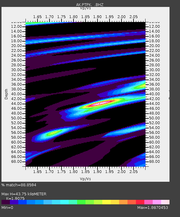
| Estimated Moho Depth: |
43.75 km |
| Estimated Crust Vp/Vs: |
1.91 |
| Assumed Crust Vp: |
6.566 km/s |
| Estimated Crust Vs: |
3.442 km/s |
| Estimated Crust Poisson's Ratio: |
0.31 |
|
| Radial Match: |
88.8594 % |
| Radial Bump: |
302 |
| Transverse Match: |
81.62712 % |
| Transverse Bump: |
400 |
| SOD ConfigId: |
512894 |
| Insert Time: |
2013-09-13 12:15:13.920 +0000 |
| GWidth: |
2.5 |
| Max Bumps: |
400 |
| Tol: |
0.001 |
|

Signal To Noise
| Channel | StoN | STA | LTA |
| AK:PTPK: :BHZ:20130419T20:04:56.167999Z | 6.353904 | 6.614796E-7 | 1.0410601E-7 |
| AK:PTPK: :BHN:20130419T20:04:56.167999Z | 0.9182683 | 1.06754754E-7 | 1.162566E-7 |
| AK:PTPK: :BHE:20130419T20:04:56.167999Z | 4.8590665 | 4.2364255E-7 | 8.7185995E-8 |
| Arrivals |
| Ps | 6.5 SECOND |
| PpPs | 18 SECOND |
| PsPs/PpSs | 24 SECOND |


