You are here: Home > Network List > CM - Red Sismologica Nacional de Columbia Stations List
> Station TUM Tumaco, Columbia > Earthquake Result Viewer
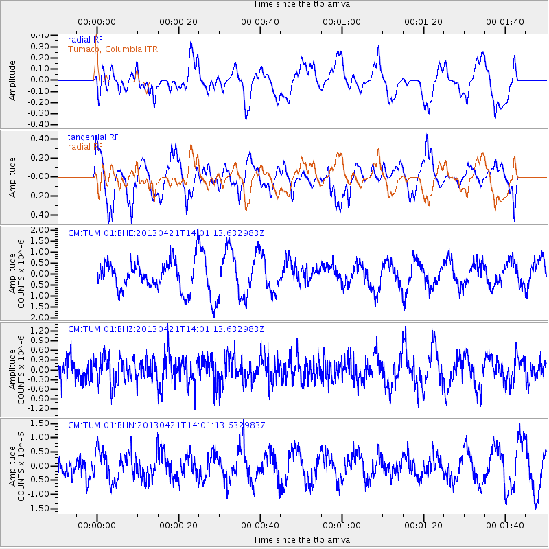
TUM Tumaco, Columbia - Earthquake Result Viewer
*The percent match for this event was below the threshold and hence no stack was calculated.
| Earthquake location: |
Andreanof Islands, Aleutian Is. |
| Earthquake latitude/longitude: |
51.7/-178.2 |
| Earthquake time(UTC): |
2013/04/21 (111) 13:48:29 GMT |
| Earthquake Depth: |
44 km |
| Earthquake Magnitude: |
5.6 MW, 5.7 MW, 5.9 MB |
| Earthquake Catalog/Contributor: |
NEIC PDE/NEIC PDE-W |
|
| Network: |
CM Red Sismologica Nacional de Columbia |
| Station: |
TUM Tumaco, Columbia |
| Lat/Lon: |
1.84 N/78.73 W |
| Elevation: |
50 m |
|
| Distance: |
94.5 deg |
| Az: |
81.401 deg |
| Baz: |
321.964 deg |
| Ray Param: |
$rayparam |
*The percent match for this event was below the threshold and hence was not used in the summary stack. |
|
| Radial Match: |
41.60917 % |
| Radial Bump: |
400 |
| Transverse Match: |
63.590454 % |
| Transverse Bump: |
400 |
| SOD ConfigId: |
512894 |
| Insert Time: |
2013-09-13 16:56:54.407 +0000 |
| GWidth: |
2.5 |
| Max Bumps: |
400 |
| Tol: |
0.001 |
|
Signal To Noise
| Channel | StoN | STA | LTA |
| CM:TUM:01:BHZ:20130421T14:01:13.632983Z | 1.1324143 | 4.3018014E-7 | 3.7987874E-7 |
| CM:TUM:01:BHN:20130421T14:01:13.632983Z | 1.2916757 | 5.637357E-7 | 4.3643746E-7 |
| CM:TUM:01:BHE:20130421T14:01:13.632983Z | 1.6791968 | 1.0697132E-6 | 6.370386E-7 |
| Arrivals |
| Ps | |
| PpPs | |
| PsPs/PpSs | |


