
Station CM TUM - Tumaco, Columbia
Network: CM - Red Sismologica Nacional de Columbia
Nearby stations (2 deg radius)
| Station | Name | (Lat, Lon) | Start / End | Elevation |
| TUM | Tumaco, Columbia | (1.84, -78.73) | 2008-01-01 / 2999-12-31 | 50 m |
| Crust2 Type: | T6,Margin /shield transition, 1 km seds. |
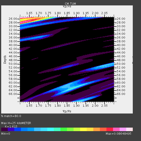
| Thickness Estimate: | 25 km |
| Thickness StdDev: | 1.2 km |
| Vp/Vs Estimate: | 1.62 |
| Vp/Vs StdDev: | 0.01 |
| Vs Estimate: | 4.007 km/s |
| Poisson's Ratio: | 0.19 |
| Peak Value: | 0.09 |
| Assumed Vp: | 6.472 km/s |
| Ps Weight: | 0.33333334 |
| PpPs Weight: | 0.33333334 |
| PsPs Weight: | 0.33333328 |
| Residual Complexity: | 0.784 |
| Nearby stations H: | +- |
| (2.0 deg) Vp/Vs: | +- |
0 with match > 90% ( 0.0 %) and 2 with match > 80% ( 5.882353 %) out of 34.
Download stack as xyz text file.
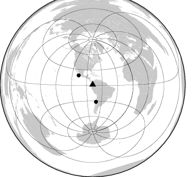
Azimuth Distribution of Events:
Prior Results for this Station
| Study | Thickness | Vp/Vs | Vp | Vs | Poissons Ratio | Extra |
| EARS | 25 km | 1.62 | 6.472 km/s | 4.007 km/s | 0.19 | |
| Crust2.0 | 32 km | 1.79 | 6.472 km/s | 3.622 km/s | 0.27 | T6,Margin /shield transition, 1 km seds. |
| Global Maxima | 25 km | 1.62 | 6.472 km/s | 4.007 km/s | 0.19 | amp=0.08648495 |
| Local Maxima 1 | 27 km | 1.63 | 6.472 km/s | 3.964 km/s | 0.20 | amp=0.06318946 |
| Local Maxima 2 | 62 km | 1.89 | 6.472 km/s | 3.429 km/s | 0.30 | amp=0.038325306 |
| Local Maxima 3 | 25 km | 1.72 | 6.472 km/s | 3.763 km/s | 0.24 | amp=0.030148312 |
| Local Maxima 4 | 70 km | 1.91 | 6.472 km/s | 3.384 km/s | 0.31 | amp=0.025883302 |
| Predicted Arrivals for vertical incidence (zero ray parameter) | |
| Ps | 2.38 SECOND |
| PpPs | 10.10 SECOND |
| PsPs/PpSs | 12.48 SECOND |
Events Processed for this Station
Download zip of receiver functions as SAC
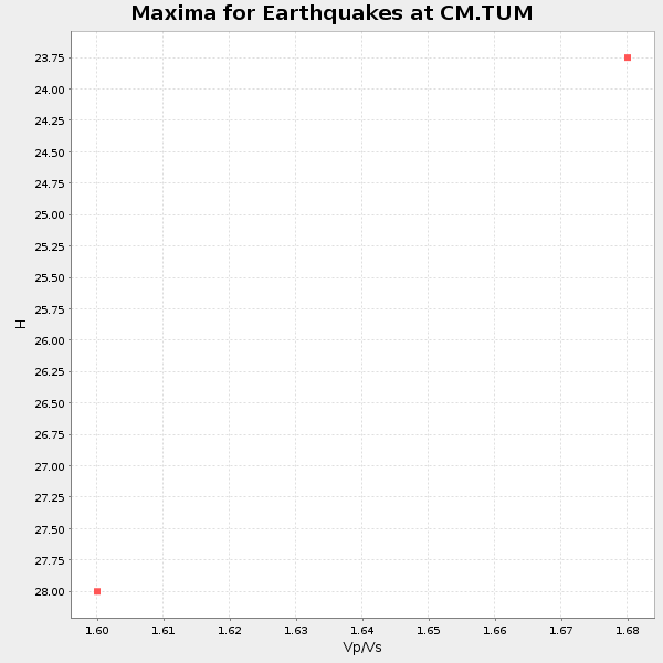
Plot maxima for each earthquake.
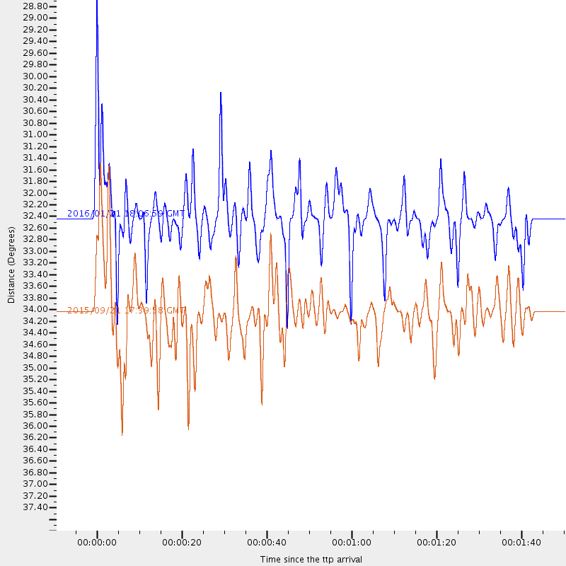
Events Used in the Stack
(2 events)| Radial Match | Distance | Baz | FERegion | Time | Lat/Lon | Depth | Magnitude |
| 83.50729 | 32.4 deg | 303.305 deg | Off Coast Of Jalisco, Mexico | 2016/01/21 18:06:59 GMT | (18.8, -107.0) | 10 km | 6.6 MWW, 6.9 MI |
| 80.04277 | 34.1 deg | 169.178 deg | Near Coast Of Central Chile | 2015/09/21 17:39:58 GMT | (-31.7, -71.6) | 25 km | 6.5 MB, 6.5 MI, 6.6 MWW |
Losers
(32 events)| Radial Match | Distance | Baz | FERegion | Time | Lat/Lon | Depth | Magnitude | Reason |
| 92.6777 | 33.9 deg | 169.289 deg | Near Coast Of Central Chile | 2015/09/16 22:54:31 GMT | (-31.6, -71.8) | 12 km | 8.3 MWW, 7.9 MI | |
| 91.04452 | 45.4 deg | 219.226 deg | Southern East Pacific Rise | 2014/10/09 02:14:32 GMT | (-32.1, -110.8) | 16 km | 7.1 MWW, 6.8 MI | |
| 84.25527 | 59.0 deg | 163.889 deg | Falkland Islands Region | 2013/11/25 06:27:33 GMT | (-53.9, -55.0) | 12 km | 7.0 MWW, 6.9 MWC, 6.9 MWB, 7.0 MWC | |
| 83.34794 | 33.2 deg | 168.426 deg | Near Coast Of Central Chile | 2015/09/26 02:51:18 GMT | (-30.8, -71.4) | 38 km | 6.2 MO | |
| 83.12776 | 81.8 deg | 326.986 deg | Alaska Peninsula | 2015/05/29 07:00:08 GMT | (56.7, -156.5) | 62 km | 6.8 MWP, 6.8 MI | |
| 81.35878 | 33.9 deg | 169.231 deg | Near Coast Of Central Chile | 2015/09/21 05:39:33 GMT | (-31.6, -71.7) | 23 km | 6.3 MWP | |
| 79.430626 | 36.1 deg | 163.182 deg | Mendoza Province, Argentina | 2015/02/02 10:49:48 GMT | (-32.7, -67.1) | 172 km | 6.3 MO | |
| 78.05817 | 36.9 deg | 74.645 deg | Northern Mid-Atlantic Ridge | 2013/06/24 22:04:13 GMT | (10.7, -42.6) | 10 km | 6.5 MW, 6.1 MB, 6.3 MS, 6.6 MW | |
| 76.056465 | 36.1 deg | 309.651 deg | Gulf Of California | 2014/10/08 02:40:54 GMT | (23.8, -108.4) | 10 km | 6.2 MWP | |
| 74.118576 | 71.6 deg | 153.076 deg | South Sandwich Islands Region | 2014/02/01 03:58:43 GMT | (-56.8, -27.3) | 130 km | 6.1 MWW, 6.1 MWC, 6.1 MWB, 6.2 MWC | |
| 73.276436 | 60.1 deg | 205.924 deg | Southern East Pacific Rise | 2014/05/12 18:38:37 GMT | (-50.0, -114.7) | 8.2 km | 5.8 MB | |
| 73.05136 | 33.9 deg | 168.419 deg | Near Coast Of Central Chile | 2015/09/22 07:12:59 GMT | (-31.5, -71.2) | 54 km | 6.1 MWB | |
| 72.02432 | 70.4 deg | 152.251 deg | South Sandwich Islands Region | 2015/02/16 22:00:53 GMT | (-55.5, -28.2) | 10 km | 6.2 MWW, 6.7 MI | |
| 69.65376 | 32.8 deg | 169.529 deg | Off Coast Of Central Chile | 2015/09/19 13:08:57 GMT | (-30.6, -72.2) | 14 km | 5.6 MB | |
| 68.4831 | 95.6 deg | 321.504 deg | Andreanof Islands, Aleutian Is. | 2013/07/07 20:17:59 GMT | (51.0, -179.9) | 6.8 km | 5.6 MB, 5.5 ML | |
| 68.043144 | 67.3 deg | 162.721 deg | Scotia Sea | 2014/02/08 19:50:36 GMT | (-60.4, -45.2) | 24 km | 5.7 MWW, 5.6 MWB, 5.8 MWC | |
| 67.20816 | 35.3 deg | 167.256 deg | Chile-Argentina Border Region | 2013/06/19 21:29:11 GMT | (-32.7, -70.0) | 104 km | 5.5 MB | |
| 64.727936 | 32.7 deg | 168.649 deg | Near Coast Of Central Chile | 2015/10/05 16:33:26 GMT | (-30.3, -71.7) | 35 km | 6.0 MB | |
| 63.94237 | 38.7 deg | 53.059 deg | Northern Mid-Atlantic Ridge | 2014/07/27 01:28:38 GMT | (23.8, -45.6) | 10 km | 5.6 MB, 6.0 MWB, 6.6 MI | |
| 62.749825 | 65.2 deg | 326.767 deg | Vancouver Island, Canada Region | 2015/09/24 13:48:58 GMT | (50.7, -130.2) | 10 km | 5.5 MB, 5.6 MI | |
| 62.218964 | 33.5 deg | 168.891 deg | Near Coast Of Central Chile | 2015/09/19 09:07:08 GMT | (-31.1, -71.6) | 23 km | 6.1 MWP | |
| 60.46292 | 33.1 deg | 168.325 deg | Near Coast Of Central Chile | 2015/12/19 19:25:04 GMT | (-30.6, -71.4) | 46 km | 5.8 MWR | |
| 59.044273 | 63.2 deg | 326.977 deg | Vancouver Island, Canada Region | 2014/04/24 03:10:13 GMT | (49.8, -127.4) | 11 km | 6.7 MWP, 6.7 MI | |
| 51.87473 | 71.0 deg | 152.691 deg | South Sandwich Islands Region | 2015/09/30 16:06:52 GMT | (-56.2, -27.7) | 106 km | 5.7 MB | |
| 47.346447 | 96.6 deg | 204.368 deg | Balleny Islands Region | 2013/04/30 14:39:16 GMT | (-65.4, 179.5) | 10 km | 5.5 MW | |
| 44.731724 | 63.1 deg | 326.799 deg | Vancouver Island, Canada Region | 2013/08/04 13:22:27 GMT | (49.7, -127.4) | 10 km | 5.6 MB, 5.5 MW | |
| 42.29427 | 59.9 deg | 205.498 deg | Southern East Pacific Rise | 2013/09/25 07:40:23 GMT | (-50.0, -114.0) | 10 km | 5.5 MWC, 5.5 MWC | |
| 41.8888 | 80.2 deg | 330.743 deg | Southern Alaska | 2014/05/10 14:16:08 GMT | (60.0, -152.2) | 96 km | 5.8 ML, 5.5 MI, 5.7 MWP | |
| 41.723557 | 96.2 deg | 255.094 deg | Tonga Islands | 2014/01/22 03:41:29 GMT | (-15.1, -174.7) | 11 km | 5.5 MWC, 5.5 MWC | |
| 41.60917 | 94.5 deg | 321.964 deg | Andreanof Islands, Aleutian Is. | 2013/04/21 13:48:29 GMT | (51.7, -178.2) | 44 km | 5.6 MW, 5.7 MW, 5.9 MB | |
| 41.25535 | 85.9 deg | 337.614 deg | Northern Alaska | 2014/04/18 18:44:17 GMT | (67.7, -162.5) | 1.0 km | 5.5 MB, 5.4 MI | |
| 36.744366 | 85.7 deg | 145.113 deg | Bouvet Island Region | 2013/04/20 05:11:57 GMT | (-54.8, 1.2) | 11 km | 5.8 MW, 5.5 MS, 5.7 MW |

