You are here: Home > Network List > TA - USArray Transportable Network (new EarthScope stations) Stations List
> Station 758A Lake Helen, FL, USA > Earthquake Result Viewer
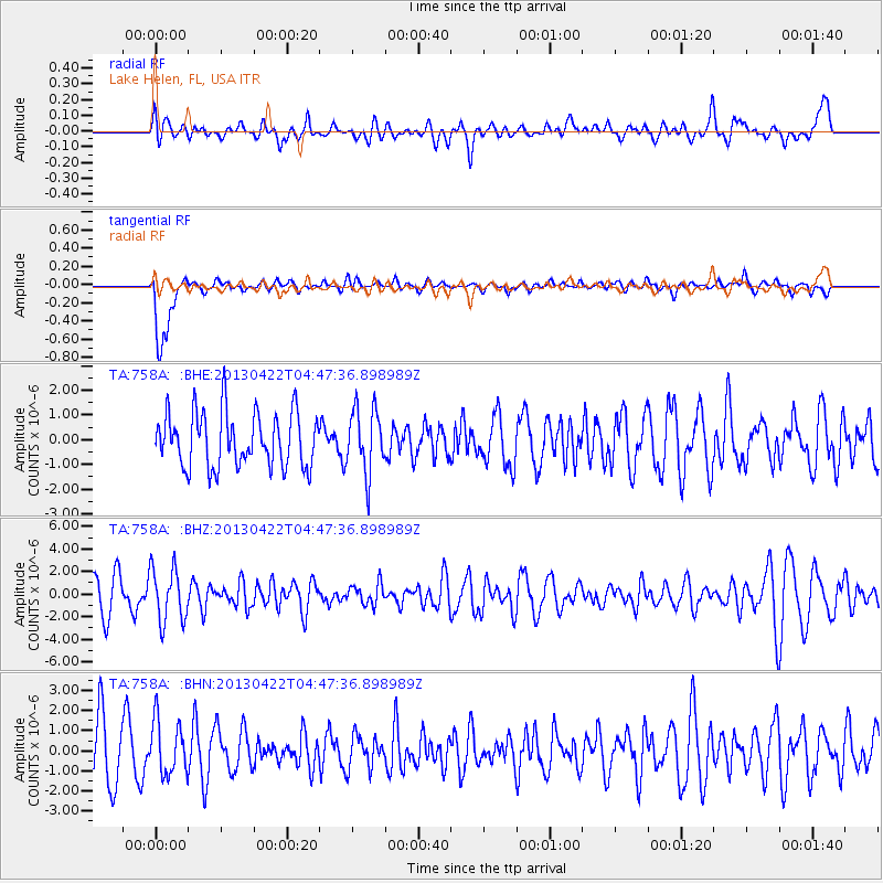
758A Lake Helen, FL, USA - Earthquake Result Viewer
*The percent match for this event was below the threshold and hence no stack was calculated.
| Earthquake location: |
Rat Islands, Aleutian Islands |
| Earthquake latitude/longitude: |
51.1/179.4 |
| Earthquake time(UTC): |
2013/04/22 (112) 04:36:36 GMT |
| Earthquake Depth: |
18 km |
| Earthquake Magnitude: |
5.6 MW, 5.5 MW |
| Earthquake Catalog/Contributor: |
NEIC PDE/NEIC PDE-W |
|
| Network: |
TA USArray Transportable Network (new EarthScope stations) |
| Station: |
758A Lake Helen, FL, USA |
| Lat/Lon: |
28.96 N/81.20 W |
| Elevation: |
16 m |
|
| Distance: |
73.5 deg |
| Az: |
64.36 deg |
| Baz: |
319.557 deg |
| Ray Param: |
$rayparam |
*The percent match for this event was below the threshold and hence was not used in the summary stack. |
|
| Radial Match: |
54.061268 % |
| Radial Bump: |
400 |
| Transverse Match: |
73.79443 % |
| Transverse Bump: |
400 |
| SOD ConfigId: |
512894 |
| Insert Time: |
2013-09-13 18:26:24.627 +0000 |
| GWidth: |
2.5 |
| Max Bumps: |
400 |
| Tol: |
0.001 |
|
Signal To Noise
| Channel | StoN | STA | LTA |
| TA:758A: :BHZ:20130422T04:47:36.898989Z | 1.7545425 | 2.37661E-6 | 1.3545468E-6 |
| TA:758A: :BHN:20130422T04:47:36.898989Z | 1.0747604 | 1.3347872E-6 | 1.2419392E-6 |
| TA:758A: :BHE:20130422T04:47:36.898989Z | 1.178339 | 1.2915821E-6 | 1.096104E-6 |
| Arrivals |
| Ps | |
| PpPs | |
| PsPs/PpSs | |


