You are here: Home > Network List > TA - USArray Transportable Network (new EarthScope stations) Stations List
> Station 059A Moore Haven, FL, USA > Earthquake Result Viewer
059A Moore Haven, FL, USA - Earthquake Result Viewer
| Earthquake location: |
Sea Of Okhotsk |
| Earthquake latitude/longitude: |
54.9/153.2 |
| Earthquake time(UTC): |
2013/05/24 (144) 05:44:48 GMT |
| Earthquake Depth: |
598 km |
| Earthquake Magnitude: |
8.4 MW, 7.5 MB, 8.3 MW |
| Earthquake Catalog/Contributor: |
NEIC PDE/NEIC PDE-W |
|
| Network: |
TA USArray Transportable Network (new EarthScope stations) |
| Station: |
059A Moore Haven, FL, USA |
| Lat/Lon: |
26.97 N/81.14 W |
| Elevation: |
11 m |
|
| Distance: |
86.1 deg |
| Az: |
46.639 deg |
| Baz: |
331.926 deg |
| Ray Param: |
0.042545043 |
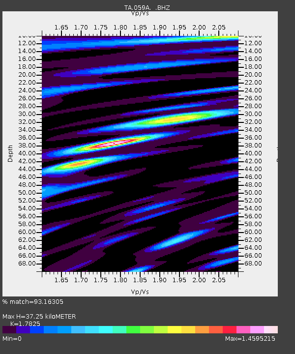
| Estimated Moho Depth: |
37.25 km |
| Estimated Crust Vp/Vs: |
1.78 |
| Assumed Crust Vp: |
6.347 km/s |
| Estimated Crust Vs: |
3.561 km/s |
| Estimated Crust Poisson's Ratio: |
0.27 |
|
| Radial Match: |
93.16305 % |
| Radial Bump: |
400 |
| Transverse Match: |
96.15215 % |
| Transverse Bump: |
400 |
| SOD ConfigId: |
512894 |
| Insert Time: |
2013-09-14 17:33:34.645 +0000 |
| GWidth: |
2.5 |
| Max Bumps: |
400 |
| Tol: |
0.001 |
|

Signal To Noise
| Channel | StoN | STA | LTA |
| TA:059A: :BHZ:20130524T05:55:56.37502Z | 13.136618 | 9.789974E-6 | 7.452431E-7 |
| TA:059A: :BHN:20130524T05:55:56.37502Z | 5.5246334 | 2.3242878E-6 | 4.2071352E-7 |
| TA:059A: :BHE:20130524T05:55:56.37502Z | 4.06615 | 1.8119218E-6 | 4.4561116E-7 |
| Arrivals |
| Ps | 4.7 SECOND |
| PpPs | 16 SECOND |
| PsPs/PpSs | 21 SECOND |


