You are here: Home > Network List > TA - USArray Transportable Network (new EarthScope stations) Stations List
> Station 758A Lake Helen, FL, USA > Earthquake Result Viewer
758A Lake Helen, FL, USA - Earthquake Result Viewer
| Earthquake location: |
Sea Of Okhotsk |
| Earthquake latitude/longitude: |
54.9/153.2 |
| Earthquake time(UTC): |
2013/05/24 (144) 05:44:48 GMT |
| Earthquake Depth: |
598 km |
| Earthquake Magnitude: |
8.4 MW, 7.5 MB, 8.3 MW |
| Earthquake Catalog/Contributor: |
NEIC PDE/NEIC PDE-W |
|
| Network: |
TA USArray Transportable Network (new EarthScope stations) |
| Station: |
758A Lake Helen, FL, USA |
| Lat/Lon: |
28.96 N/81.20 W |
| Elevation: |
16 m |
|
| Distance: |
84.3 deg |
| Az: |
45.742 deg |
| Baz: |
331.826 deg |
| Ray Param: |
0.0437867 |
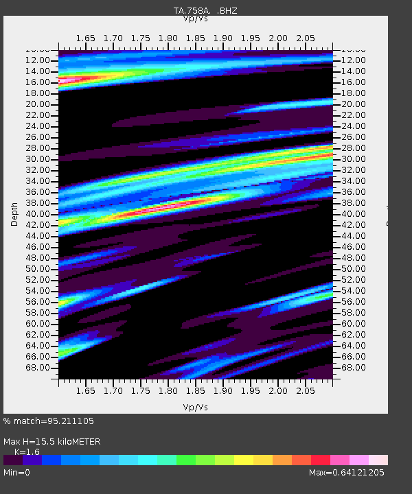
| Estimated Moho Depth: |
15.5 km |
| Estimated Crust Vp/Vs: |
1.60 |
| Assumed Crust Vp: |
6.134 km/s |
| Estimated Crust Vs: |
3.834 km/s |
| Estimated Crust Poisson's Ratio: |
0.18 |
|
| Radial Match: |
95.211105 % |
| Radial Bump: |
400 |
| Transverse Match: |
92.69899 % |
| Transverse Bump: |
400 |
| SOD ConfigId: |
512894 |
| Insert Time: |
2013-09-14 17:36:03.830 +0000 |
| GWidth: |
2.5 |
| Max Bumps: |
400 |
| Tol: |
0.001 |
|

Signal To Noise
| Channel | StoN | STA | LTA |
| TA:758A: :BHZ:20130524T05:55:47.873982Z | 11.770405 | 1.0092533E-5 | 8.5744995E-7 |
| TA:758A: :BHN:20130524T05:55:47.873982Z | 9.126256 | 3.1626857E-6 | 3.4654798E-7 |
| TA:758A: :BHE:20130524T05:55:47.873982Z | 5.1380663 | 1.5805923E-6 | 3.0762394E-7 |
| Arrivals |
| Ps | 1.6 SECOND |
| PpPs | 6.4 SECOND |
| PsPs/PpSs | 8.0 SECOND |


