You are here: Home > Network List > TA - USArray Transportable Network (new EarthScope stations) Stations List
> Station 457A Yulee, FL, USA > Earthquake Result Viewer
457A Yulee, FL, USA - Earthquake Result Viewer

| Earthquake location: |
Sea Of Okhotsk |
| Earthquake latitude/longitude: |
52.2/151.4 |
| Earthquake time(UTC): |
2013/05/24 (144) 14:56:31 GMT |
| Earthquake Depth: |
624 km |
| Earthquake Magnitude: |
6.7 MW, 6.7 MB, 6.7 MW |
| Earthquake Catalog/Contributor: |
NEIC PDE/NEIC PDE-W |
|
| Network: |
TA USArray Transportable Network (new EarthScope stations) |
| Station: |
457A Yulee, FL, USA |
| Lat/Lon: |
30.62 N/81.56 W |
| Elevation: |
16 m |
|
| Distance: |
85.4 deg |
| Az: |
43.687 deg |
| Baz: |
330.478 deg |
| Ray Param: |
0.042966653 |
| Estimated Moho Depth: |
22.0 km |
| Estimated Crust Vp/Vs: |
1.69 |
| Assumed Crust Vp: |
5.989 km/s |
| Estimated Crust Vs: |
3.544 km/s |
| Estimated Crust Poisson's Ratio: |
0.23 |
|
| Radial Match: |
90.34912 % |
| Radial Bump: |
400 |
| Transverse Match: |
77.194725 % |
| Transverse Bump: |
400 |
| SOD ConfigId: |
512894 |
| Insert Time: |
2013-09-14 19:25:11.151 +0000 |
| GWidth: |
2.5 |
| Max Bumps: |
400 |
| Tol: |
0.001 |
|
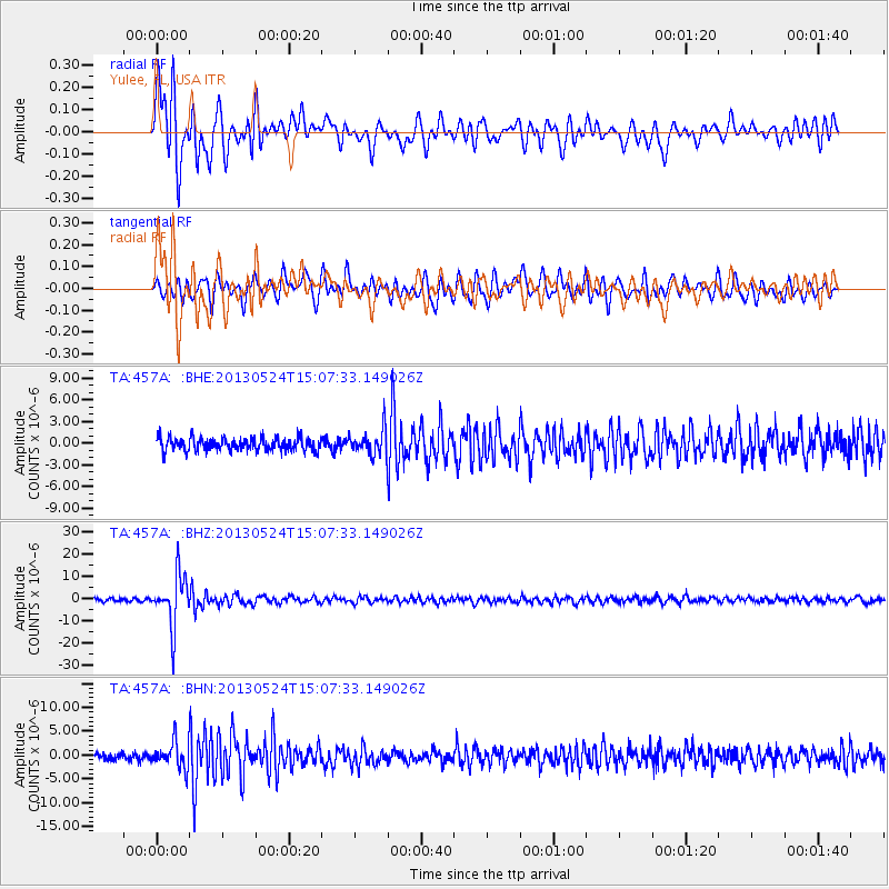
Signal To Noise
| Channel | StoN | STA | LTA |
| TA:457A: :BHZ:20130524T15:07:33.149026Z | 16.05994 | 1.1332677E-5 | 7.0564874E-7 |
| TA:457A: :BHN:20130524T15:07:33.149026Z | 3.754637 | 2.7180897E-6 | 7.2392874E-7 |
| TA:457A: :BHE:20130524T15:07:33.149026Z | 2.0355093 | 1.7709958E-6 | 8.7005054E-7 |
| Arrivals |
| Ps | 2.6 SECOND |
| PpPs | 9.7 SECOND |
| PsPs/PpSs | 12 SECOND |


