You are here: Home > Network List > TA - USArray Transportable Network (new EarthScope stations) Stations List
> Station 758A Lake Helen, FL, USA > Earthquake Result Viewer
758A Lake Helen, FL, USA - Earthquake Result Viewer
| Earthquake location: |
Sea Of Okhotsk |
| Earthquake latitude/longitude: |
52.2/151.4 |
| Earthquake time(UTC): |
2013/05/24 (144) 14:56:31 GMT |
| Earthquake Depth: |
624 km |
| Earthquake Magnitude: |
6.7 MW, 6.7 MB, 6.7 MW |
| Earthquake Catalog/Contributor: |
NEIC PDE/NEIC PDE-W |
|
| Network: |
TA USArray Transportable Network (new EarthScope stations) |
| Station: |
758A Lake Helen, FL, USA |
| Lat/Lon: |
28.96 N/81.20 W |
| Elevation: |
16 m |
|
| Distance: |
87.0 deg |
| Az: |
44.23 deg |
| Baz: |
330.69 deg |
| Ray Param: |
0.04184937 |
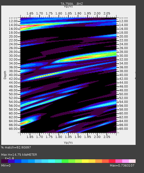
| Estimated Moho Depth: |
14.75 km |
| Estimated Crust Vp/Vs: |
1.60 |
| Assumed Crust Vp: |
6.134 km/s |
| Estimated Crust Vs: |
3.834 km/s |
| Estimated Crust Poisson's Ratio: |
0.18 |
|
| Radial Match: |
92.90897 % |
| Radial Bump: |
400 |
| Transverse Match: |
85.72259 % |
| Transverse Bump: |
400 |
| SOD ConfigId: |
512894 |
| Insert Time: |
2013-09-14 19:25:41.715 +0000 |
| GWidth: |
2.5 |
| Max Bumps: |
400 |
| Tol: |
0.001 |
|

Signal To Noise
| Channel | StoN | STA | LTA |
| TA:758A: :BHZ:20130524T15:07:40.649026Z | 38.83077 | 1.558734E-5 | 4.0141725E-7 |
| TA:758A: :BHN:20130524T15:07:40.649026Z | 13.975632 | 5.3731096E-6 | 3.8446274E-7 |
| TA:758A: :BHE:20130524T15:07:40.649026Z | 6.3895025 | 2.5523375E-6 | 3.9945795E-7 |
| Arrivals |
| Ps | 1.5 SECOND |
| PpPs | 6.1 SECOND |
| PsPs/PpSs | 7.6 SECOND |


