You are here: Home > Network List > AK - Alaska Regional Network Stations List
> Station PTPK Patty Peak Repeater, AK, USA > Earthquake Result Viewer
PTPK Patty Peak Repeater, AK, USA - Earthquake Result Viewer
| Earthquake location: |
Taiwan |
| Earthquake latitude/longitude: |
23.8/121.1 |
| Earthquake time(UTC): |
2013/06/02 (153) 05:43:03 GMT |
| Earthquake Depth: |
17 km |
| Earthquake Magnitude: |
6.2 MW, 6.1 MB, 6.2 MS, 6.2 MW |
| Earthquake Catalog/Contributor: |
NEIC PDE/NEIC PDE-W |
|
| Network: |
AK Alaska Regional Network |
| Station: |
PTPK Patty Peak Repeater, AK, USA |
| Lat/Lon: |
61.19 N/142.47 W |
| Elevation: |
1933 m |
|
| Distance: |
72.5 deg |
| Az: |
30.326 deg |
| Baz: |
287.299 deg |
| Ray Param: |
0.053636752 |
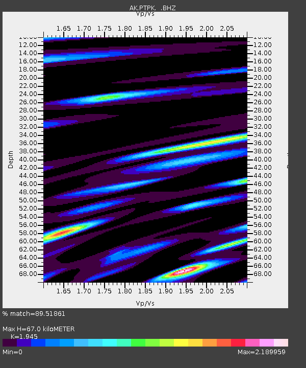
| Estimated Moho Depth: |
67.0 km |
| Estimated Crust Vp/Vs: |
1.95 |
| Assumed Crust Vp: |
6.566 km/s |
| Estimated Crust Vs: |
3.376 km/s |
| Estimated Crust Poisson's Ratio: |
0.32 |
|
| Radial Match: |
89.51861 % |
| Radial Bump: |
400 |
| Transverse Match: |
78.1229 % |
| Transverse Bump: |
400 |
| SOD ConfigId: |
512894 |
| Insert Time: |
2013-09-14 22:43:16.339 +0000 |
| GWidth: |
2.5 |
| Max Bumps: |
400 |
| Tol: |
0.001 |
|

Signal To Noise
| Channel | StoN | STA | LTA |
| AK:PTPK: :BHZ:20130602T05:53:57.60801Z | 7.1060066 | 5.8518594E-7 | 8.235088E-8 |
| AK:PTPK: :BHN:20130602T05:53:57.60801Z | 2.6195285 | 2.516561E-7 | 9.6069236E-8 |
| AK:PTPK: :BHE:20130602T05:53:57.60801Z | 5.9014187 | 4.5217234E-7 | 7.662096E-8 |
| Arrivals |
| Ps | 10.0 SECOND |
| PpPs | 29 SECOND |
| PsPs/PpSs | 39 SECOND |


