You are here: Home > Network List > TA - USArray Transportable Network (new EarthScope stations) Stations List
> Station 858A St. Cloud, FL, USA > Earthquake Result Viewer
858A St. Cloud, FL, USA - Earthquake Result Viewer
| Earthquake location: |
Northern Mid-Atlantic Ridge |
| Earthquake latitude/longitude: |
10.7/-42.6 |
| Earthquake time(UTC): |
2013/06/24 (175) 22:04:13 GMT |
| Earthquake Depth: |
10 km |
| Earthquake Magnitude: |
6.5 MW, 6.1 MB, 6.3 MS, 6.6 MW |
| Earthquake Catalog/Contributor: |
NEIC PDE/NEIC PDE-W |
|
| Network: |
TA USArray Transportable Network (new EarthScope stations) |
| Station: |
858A St. Cloud, FL, USA |
| Lat/Lon: |
28.21 N/81.36 W |
| Elevation: |
27 m |
|
| Distance: |
40.3 deg |
| Az: |
301.246 deg |
| Baz: |
107.799 deg |
| Ray Param: |
0.074494235 |
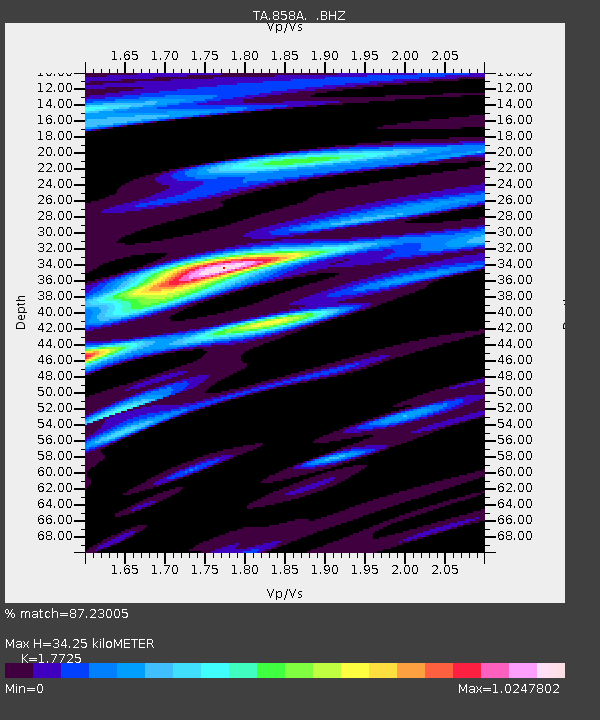
| Estimated Moho Depth: |
34.25 km |
| Estimated Crust Vp/Vs: |
1.77 |
| Assumed Crust Vp: |
6.134 km/s |
| Estimated Crust Vs: |
3.461 km/s |
| Estimated Crust Poisson's Ratio: |
0.27 |
|
| Radial Match: |
87.23005 % |
| Radial Bump: |
400 |
| Transverse Match: |
64.36121 % |
| Transverse Bump: |
400 |
| SOD ConfigId: |
512894 |
| Insert Time: |
2013-09-15 09:37:20.180 +0000 |
| GWidth: |
2.5 |
| Max Bumps: |
400 |
| Tol: |
0.001 |
|
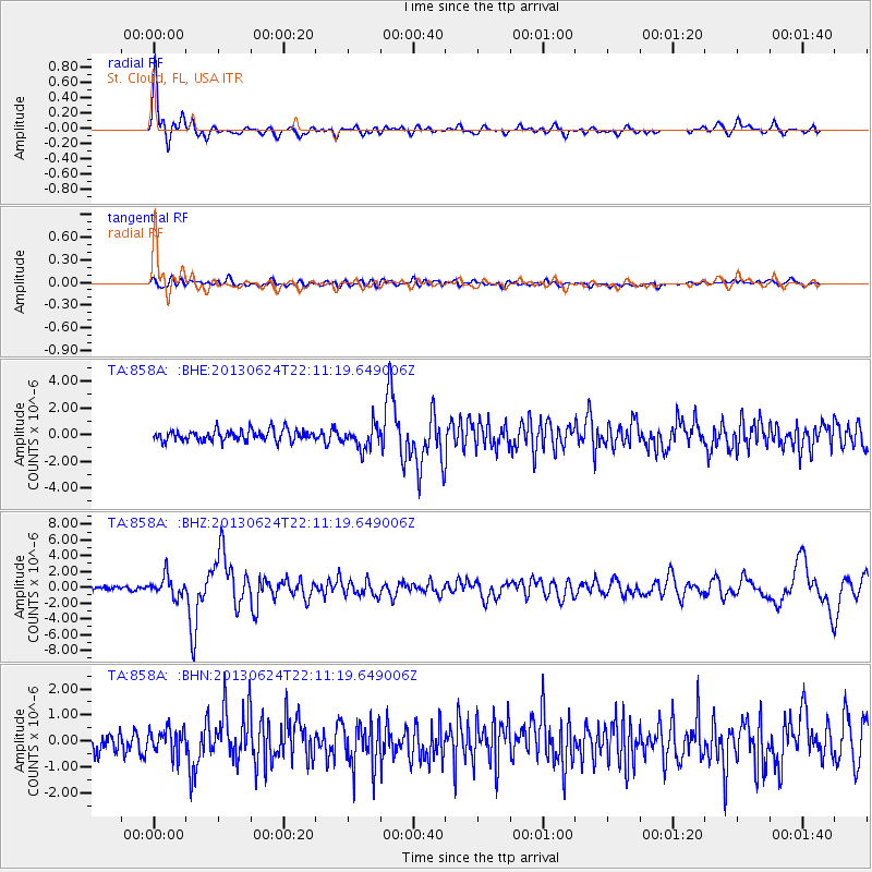
Signal To Noise
| Channel | StoN | STA | LTA |
| TA:858A: :BHZ:20130624T22:11:19.649006Z | 5.1523886 | 1.2885689E-6 | 2.5009157E-7 |
| TA:858A: :BHN:20130624T22:11:19.649006Z | 1.4332533 | 4.965449E-7 | 3.4644603E-7 |
| TA:858A: :BHE:20130624T22:11:19.649006Z | 2.0893302 | 8.7304556E-7 | 4.1785907E-7 |
| Arrivals |
| Ps | 4.6 SECOND |
| PpPs | 15 SECOND |
| PsPs/PpSs | 19 SECOND |


