You are here: Home > Network List > AK - Alaska Regional Network Stations List
> Station BAL Baldy Mountain > Earthquake Result Viewer
BAL Baldy Mountain - Earthquake Result Viewer
| Earthquake location: |
Solomon Islands |
| Earthquake latitude/longitude: |
-7.0/155.7 |
| Earthquake time(UTC): |
2013/07/04 (185) 17:15:54 GMT |
| Earthquake Depth: |
29 km |
| Earthquake Magnitude: |
6.1 MW, 5.7 MB, 6.0 MS, 6.1 MW |
| Earthquake Catalog/Contributor: |
NEIC PDE/NEIC PDE-W |
|
| Network: |
AK Alaska Regional Network |
| Station: |
BAL Baldy Mountain |
| Lat/Lon: |
61.04 N/142.34 W |
| Elevation: |
1341 m |
|
| Distance: |
83.0 deg |
| Az: |
25.638 deg |
| Baz: |
241.925 deg |
| Ray Param: |
0.046433035 |
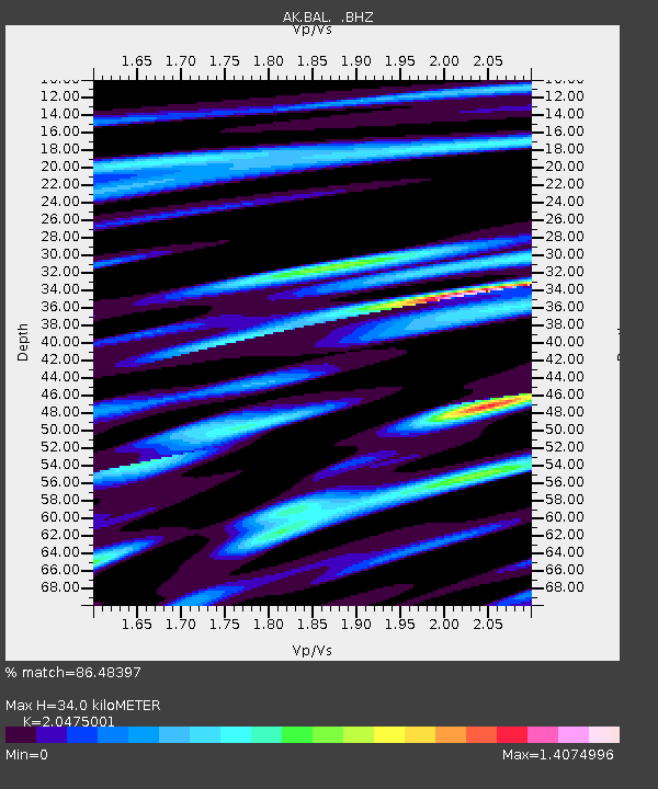
| Estimated Moho Depth: |
34.0 km |
| Estimated Crust Vp/Vs: |
2.05 |
| Assumed Crust Vp: |
6.566 km/s |
| Estimated Crust Vs: |
3.207 km/s |
| Estimated Crust Poisson's Ratio: |
0.34 |
|
| Radial Match: |
86.48397 % |
| Radial Bump: |
400 |
| Transverse Match: |
43.657516 % |
| Transverse Bump: |
400 |
| SOD ConfigId: |
512894 |
| Insert Time: |
2013-09-15 14:12:39.333 +0000 |
| GWidth: |
2.5 |
| Max Bumps: |
400 |
| Tol: |
0.001 |
|

Signal To Noise
| Channel | StoN | STA | LTA |
| AK:BAL: :BHZ:20130704T17:27:45.907981Z | 8.3143835 | 3.1495375E-7 | 3.788059E-8 |
| AK:BAL: :BHN:20130704T17:27:45.907981Z | 1.1010103 | 9.918273E-8 | 9.0083375E-8 |
| AK:BAL: :BHE:20130704T17:27:45.907981Z | 3.4049814 | 1.5893326E-7 | 4.6676693E-8 |
| Arrivals |
| Ps | 5.6 SECOND |
| PpPs | 15 SECOND |
| PsPs/PpSs | 21 SECOND |


