You are here: Home > Network List > UW - Pacific Northwest Regional Seismic Network Stations List
> Station TOLO Toledo BPA, OR CREST BB SMO > Earthquake Result Viewer
TOLO Toledo BPA, OR CREST BB SMO - Earthquake Result Viewer

| Earthquake location: |
Mariana Islands |
| Earthquake latitude/longitude: |
18.9/145.4 |
| Earthquake time(UTC): |
2007/10/31 (304) 03:30:17 GMT |
| Earthquake Depth: |
223 km |
| Earthquake Magnitude: |
6.2 MB, 7.2 MW, 7.2 MW |
| Earthquake Catalog/Contributor: |
WHDF/NEIC |
|
| Network: |
UW Pacific Northwest Regional Seismic Network |
| Station: |
TOLO Toledo BPA, OR CREST BB SMO |
| Lat/Lon: |
44.62 N/123.92 W |
| Elevation: |
21 m |
|
| Distance: |
77.5 deg |
| Az: |
47.01 deg |
| Baz: |
284.12 deg |
| Ray Param: |
0.049716223 |
| Estimated Moho Depth: |
13.75 km |
| Estimated Crust Vp/Vs: |
1.76 |
| Assumed Crust Vp: |
6.566 km/s |
| Estimated Crust Vs: |
3.731 km/s |
| Estimated Crust Poisson's Ratio: |
0.26 |
|
| Radial Match: |
81.744896 % |
| Radial Bump: |
400 |
| Transverse Match: |
61.457756 % |
| Transverse Bump: |
400 |
| SOD ConfigId: |
2564 |
| Insert Time: |
2010-02-27 05:05:35.195 +0000 |
| GWidth: |
2.5 |
| Max Bumps: |
400 |
| Tol: |
0.001 |
|
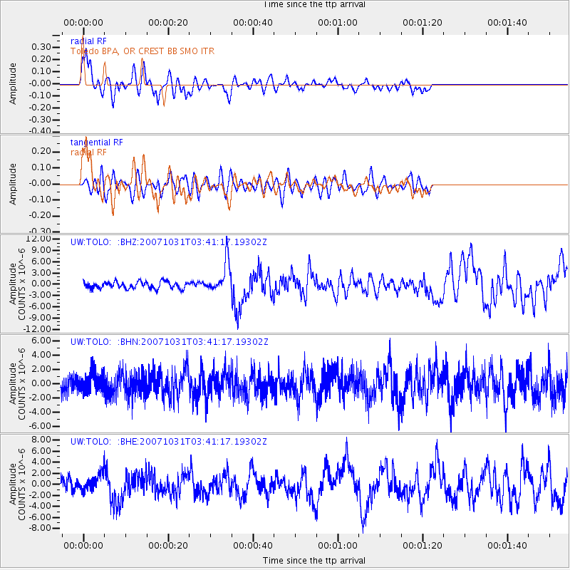
Signal To Noise
| Channel | StoN | STA | LTA |
| UW:TOLO: :BHN:20071031T03:41:17.19302Z | 0.9063907 | 1.4616123E-6 | 1.6125632E-6 |
| UW:TOLO: :BHE:20071031T03:41:17.19302Z | 1.2823652 | 1.4715162E-6 | 1.1475017E-6 |
| UW:TOLO: :BHZ:20071031T03:41:17.19302Z | 4.64784 | 4.2589445E-6 | 9.163277E-7 |
| Arrivals |
| Ps | 1.6 SECOND |
| PpPs | 5.6 SECOND |
| PsPs/PpSs | 7.2 SECOND |


