
Station UW TOLO - Toledo BPA, OR CREST BB SMO
Network: UW - Pacific Northwest Regional Seismic Network
Nearby stations (2 deg radius)
| Station | Name | (Lat, Lon) | Start / End | Elevation |
| TOLO | Toledo BPA, OR CREST BB SMO | (44.62, -123.92) | 2001-10-23 / 2499-01-01 | 0.0 km |
| Crust2 Type: | L8,thin continental arc, Cordilleras, 0.5 km seds. |
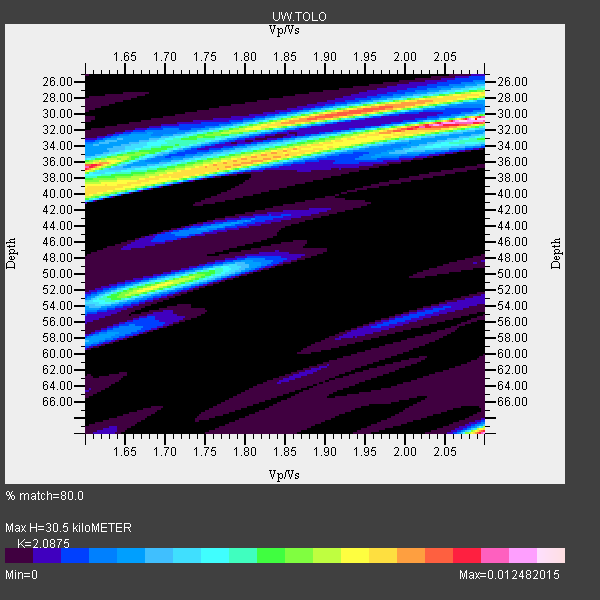
| Thickness Estimate: | 30 km |
| Thickness StdDev: | 12 km |
| Vp/Vs Estimate: | 2.09 |
| Vp/Vs StdDev: | 0.21 |
| Vs Estimate: | 3.145 km/s |
| Poisson's Ratio: | 0.35 |
| Peak Value: | 0.01 |
| Assumed Vp: | 6.566 km/s |
| Ps Weight: | 0.33333334 |
| PpPs Weight: | 0.33333334 |
| PsPs Weight: | 0.33333328 |
| Residual Complexity: | 0.820 |
| Nearby stations H: | +- |
| (2.0 deg) Vp/Vs: | +- |
2 with match > 90% ( 8.0 %) and 8 with match > 80% ( 32.0 %) out of 25.
Download stack as xyz text file.
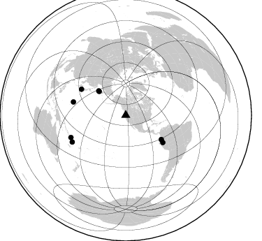
Azimuth Distribution of Events:
Prior Results for this Station
| Study | Thickness | Vp/Vs | Vp | Vs | Poissons Ratio | Extra |
| EARS | 30 km | 2.09 | 6.566 km/s | 3.145 km/s | 0.35 | |
| Crust2.0 | 34 km | 1.77 | 6.566 km/s | 3.707 km/s | 0.27 | L8,thin continental arc, Cordilleras, 0.5 km seds. |
| Global Maxima | 30 km | 2.09 | 6.566 km/s | 3.145 km/s | 0.35 | amp=0.012482015 |
| Local Maxima 1 | 70 km | 2.10 | 6.566 km/s | 3.13 km/s | 0.35 | amp=0.011631564 |
| Local Maxima 2 | 30 km | 1.93 | 6.566 km/s | 3.407 km/s | 0.32 | amp=0.009772187 |
| Local Maxima 3 | 36 km | 1.60 | 6.566 km/s | 4.097 km/s | 0.18 | amp=0.00882841 |
| Local Maxima 4 | 51 km | 1.70 | 6.566 km/s | 3.874 km/s | 0.23 | amp=0.007505721 |
| Predicted Arrivals for vertical incidence (zero ray parameter) | |
| Ps | 5.05 SECOND |
| PpPs | 14.34 SECOND |
| PsPs/PpSs | 19.39 SECOND |
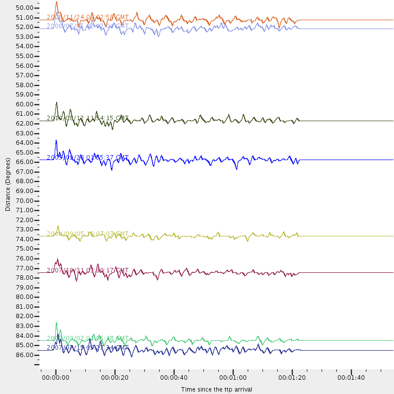
Events Processed for this Station
Download zip of receiver functions as SAC
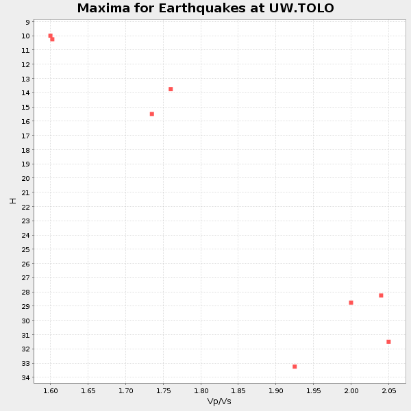
Plot maxima for each earthquake.
Events Used in the Stack
(8 events)| Radial Match | Distance | Baz | FERegion | Time | Lat/Lon | Depth | Magnitude |
| 94.01976 | 84.5 deg | 247.942 deg | Santa Cruz Islands | 2007/09/02 01:05:18 GMT | (-11.6, 165.8) | 35 km | 5.9 MB, 7.3 MS, 7.2 MW, 6.9 ME |
| 90.75695 | 65.7 deg | 126.373 deg | Northern Peru | 2005/09/26 01:55:37 GMT | (-5.7, -76.4) | 115 km | 6.7 MB, 7.5 MW, 7.5 MW |
| 87.41647 | 61.6 deg | 124.34 deg | Ecuador | 2010/08/12 11:54:15 GMT | (-1.3, -77.3) | 207 km | 6.4 MB, 7.1 MW, 7.1 MW |
| 86.85957 | 73.6 deg | 300.323 deg | Near S. Coast Of Western Honshu | 2004/09/05 10:07:07 GMT | (33.1, 136.6) | 14 km | 6.7 MB, 7.0 MS, 7.2 MW, 7.0 MW |
| 84.93015 | 52.1 deg | 311.842 deg | Sea Of Okhotsk | 2008/07/05 02:12:04 GMT | (53.9, 152.9) | 633 km | 6.8 MB, 7.7 MW, 7.7 MW |
| 84.02629 | 51.2 deg | 311.748 deg | Sea Of Okhotsk | 2008/11/24 09:02:58 GMT | (54.2, 154.3) | 492 km | 6.5 MB, 7.3 MW, 7.3 MW |
| 81.744896 | 77.5 deg | 284.12 deg | Mariana Islands | 2007/10/31 03:30:17 GMT | (18.9, 145.4) | 223 km | 6.2 MB, 7.2 MW, 7.2 MW |
| 80.178894 | 85.5 deg | 243.366 deg | Vanuatu Islands | 2007/07/15 09:27:34 GMT | (-15.4, 168.6) | 8.0 km | 6.0 MB, 5.8 MS, 6.1 MW, 6.0 MW |
Losers
(17 events)| Radial Match | Distance | Baz | FERegion | Time | Lat/Lon | Depth | Magnitude | Reason |
| 76.730064 | 89.4 deg | 237.358 deg | Southeast Of Loyalty Islands | 2009/01/15 07:27:20 GMT | (-22.4, 170.6) | 27 km | 5.8 MB, 6.5 MS, 6.7 MW, 6.6 MW | |
| 75.67064 | 85.1 deg | 245.798 deg | Vanuatu Islands | 2008/09/08 18:52:06 GMT | (-13.5, 167.0) | 110 km | 6.4 MB, 6.9 MW, 6.9 MW | |
| 71.12022 | 36.8 deg | 301.569 deg | Andreanof Islands, Aleutian Is. | 2008/04/15 22:59:51 GMT | (51.9, -179.4) | 10 km | 6.1 MB, 6.4 MS, 6.4 MW, 6.4 MW | |
| 68.32485 | 70.6 deg | 310.979 deg | E. Russia-N.E. China Border Reg. | 2010/02/18 01:13:19 GMT | (42.6, 130.7) | 578 km | 6.3 MB, 6.9 MW, 6.9 MW | |
| 61.369232 | 58.0 deg | 118.454 deg | Colombia | 2008/09/13 09:32:01 GMT | (4.8, -75.5) | 133 km | 5.9 MB, 5.7 MW, 5.7 MW | |
| 61.266754 | 83.9 deg | 125.934 deg | Southern Bolivia | 2008/10/12 20:55:41 GMT | (-20.1, -65.0) | 353 km | 6.0 MB, 6.2 MW, 6.2 MW | |
| 60.3809 | 37.8 deg | 18.956 deg | Baffin Bay | 2009/07/07 19:11:46 GMT | (75.4, -72.5) | 19 km | 5.9 MB, 5.7 MS, 6.1 MW, 6.0 MW | |
| 56.862755 | 64.2 deg | 305.095 deg | Hokkaido, Japan Region | 2009/02/28 00:35:56 GMT | (42.6, 142.1) | 105 km | 5.5 MB, 5.5 MW, 5.5 MW | |
| 56.572197 | 89.5 deg | 262.412 deg | New Britain Region, P.N.G. | 2008/08/04 15:16:53 GMT | (-5.1, 151.8) | 45 km | 5.5 MW, 4.8 MS, 5.2 MB | |
| 56.06513 | 40.8 deg | 126.773 deg | Guatemala | 2009/05/03 16:21:47 GMT | (14.6, -91.2) | 124 km | 5.6 MB, 6.2 MW, 6.2 MW | |
| 54.299595 | 90.2 deg | 223.562 deg | Kermadec Islands Region | 2009/05/24 00:58:02 GMT | (-31.5, -177.7) | 4.0 km | 5.6 MB, 5.9 MS, 6.0 MW, 5.8 MW | |
| 50.395184 | 90.6 deg | 329.554 deg | Qinghai, China | 2009/08/28 02:16:08 GMT | (37.7, 95.8) | 16 km | 5.6 MB | |
| 49.222397 | 42.0 deg | 126.988 deg | Near Coast Of Guatemala | 2008/04/15 03:03:04 GMT | (13.6, -90.6) | 33 km | 5.6 MB, 5.8 MS, 6.1 MW, 6.1 MW | |
| 48.65957 | 41.7 deg | 127.441 deg | Near Coast Of Guatemala | 2008/05/27 11:27:55 GMT | (13.6, -91.0) | 26 km | 5.7 MW, 5.1 MS, 5.3 MB, 5.6 MW | |
| 48.482452 | 33.3 deg | 299.89 deg | Andreanof Islands, Aleutian Is. | 2010/03/09 14:06:52 GMT | (51.5, -173.5) | 35 km | 5.7 MB, 5.5 MS, 5.9 MW, 5.8 MW | |
| 40.099403 | 49.8 deg | 104.642 deg | Haiti Region | 2010/01/12 22:00:41 GMT | (18.4, -72.8) | 10 km | 6.0 MB | |
| 39.86051 | 91.7 deg | 139.188 deg | Near Coast Of Central Chile | 2010/03/11 14:55:27 GMT | (-34.3, -71.8) | 18 km | 6.5 MB, 6.7 MW |
