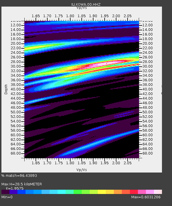
KOWA Kowa, Mali - Earthquake Result Viewer
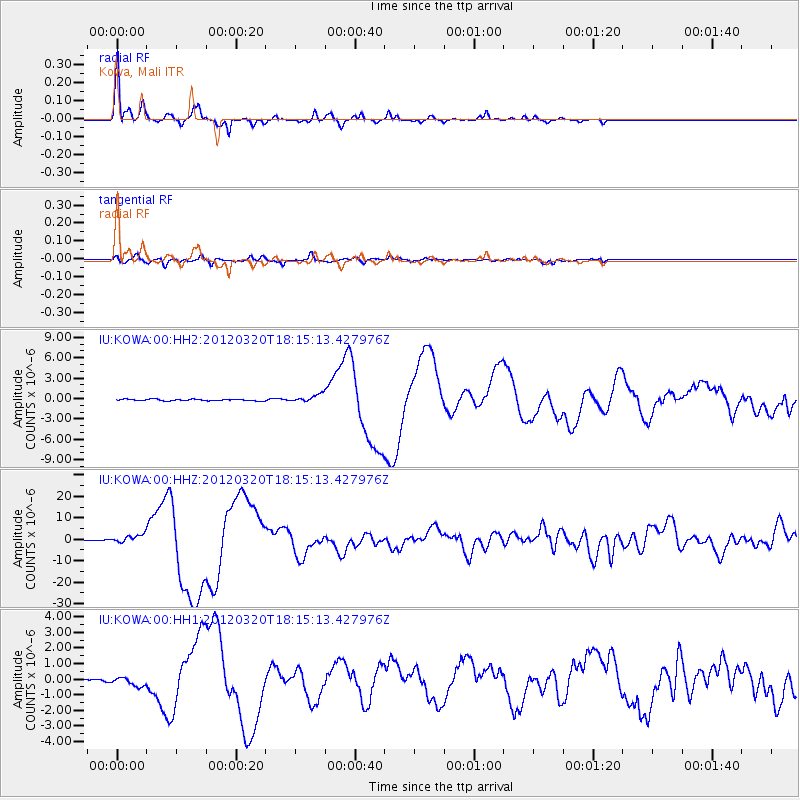
Earthquake location: Near Coast Of Guerrero, Mexico
Earthquake latitude/longitude: 16.5/-98.2
Earthquake time(UTC): 2012/03/20 (080) 18:02:47 GMT
Earthquake Depth: 20 km
Earthquake Magnitude: 6.6 MB, 7.6 MS, 7.4 MW, 7.4 MW
Earthquake Catalog/Contributor: WHDF/NEIC
Network: IU Global Seismograph Network (GSN - IRIS/USGS)
Station: KOWA Kowa, Mali
Lat/Lon: 14.50 N/4.01 W
Elevation: 321 m
Distance: 89.9 deg
Az: 75.005 deg
Baz: 286.908 deg
Ray Param: 0.041710593
Estimated Moho Depth: 28.5 km
Estimated Crust Vp/Vs: 1.96
Assumed Crust Vp: 6.31 km/s
Estimated Crust Vs: 3.223 km/s
Estimated Crust Poisson's Ratio: 0.32
Radial Match: 96.43893 %
Radial Bump: 307
Transverse Match: 83.80948 %
Transverse Bump: 400
SOD ConfigId: 558545
Insert Time: 2013-09-19 14:18:35.238 +0000
GWidth: 2.5
Max Bumps: 400
Tol: 0.001

Signal To Noise

ChannelStoNSTALTA
IU:KOWA:00:HHZ:20120320T18:15:13.427976Z7.0648691.7614685E-62.4932785E-7
IU:KOWA:00:HH1:20120320T18:15:13.427976Z2.98846172.8080564E-79.396328E-8
IU:KOWA:00:HH2:20120320T18:15:13.427976Z4.71803865.545816E-71.1754495E-7
Arrivals
Ps4.4 SECOND
PpPs13 SECOND
PsPs/PpSs18 SECOND