You are here: Home > Network List > IU - Global Seismograph Network (GSN - IRIS/USGS) Stations List
> Station KOWA Kowa, Mali > Earthquake Result Viewer
KOWA Kowa, Mali - Earthquake Result Viewer
| Earthquake location: |
Northern Italy |
| Earthquake latitude/longitude: |
44.9/11.1 |
| Earthquake time(UTC): |
2012/05/29 (150) 07:00:03 GMT |
| Earthquake Depth: |
10 km |
| Earthquake Magnitude: |
5.9 MB, 5.8 MS, 5.8 MW, 5.8 MW |
| Earthquake Catalog/Contributor: |
WHDF/NEIC |
|
| Network: |
IU Global Seismograph Network (GSN - IRIS/USGS) |
| Station: |
KOWA Kowa, Mali |
| Lat/Lon: |
14.50 N/4.01 W |
| Elevation: |
321 m |
|
| Distance: |
32.9 deg |
| Az: |
207.712 deg |
| Baz: |
19.969 deg |
| Ray Param: |
0.07847216 |
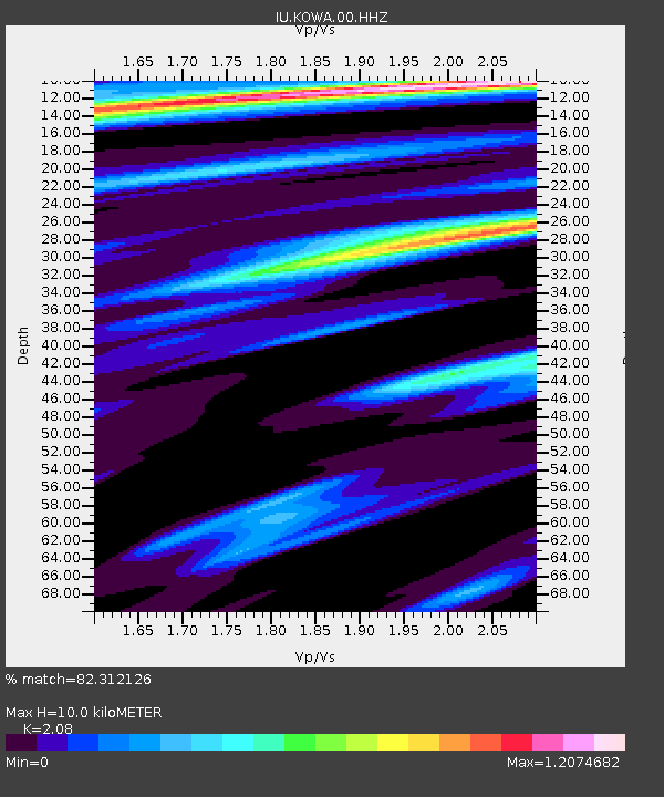
| Estimated Moho Depth: |
10.0 km |
| Estimated Crust Vp/Vs: |
2.08 |
| Assumed Crust Vp: |
6.31 km/s |
| Estimated Crust Vs: |
3.034 km/s |
| Estimated Crust Poisson's Ratio: |
0.35 |
|
| Radial Match: |
82.312126 % |
| Radial Bump: |
371 |
| Transverse Match: |
61.887993 % |
| Transverse Bump: |
400 |
| SOD ConfigId: |
558545 |
| Insert Time: |
2013-09-19 19:29:50.436 +0000 |
| GWidth: |
2.5 |
| Max Bumps: |
400 |
| Tol: |
0.001 |
|
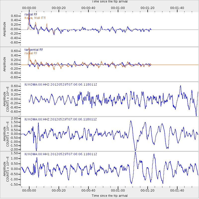
Signal To Noise
| Channel | StoN | STA | LTA |
| IU:KOWA:00:HHZ:20120529T07:06:06.118011Z | 3.0463789 | 6.1612343E-7 | 2.022478E-7 |
| IU:KOWA:00:HH1:20120529T07:06:06.118011Z | 3.227123 | 3.6212953E-7 | 1.1221435E-7 |
| IU:KOWA:00:HH2:20120529T07:06:06.118011Z | 1.5403681 | 1.8405849E-7 | 1.1948994E-7 |
| Arrivals |
| Ps | 1.8 SECOND |
| PpPs | 4.6 SECOND |
| PsPs/PpSs | 6.4 SECOND |


