You are here: Home > Network List > YS04 - Plume Lithosphere Undersea Melt Experiment Stations List
> Station PL45 WHOI OBS ID S03 > Earthquake Result Viewer
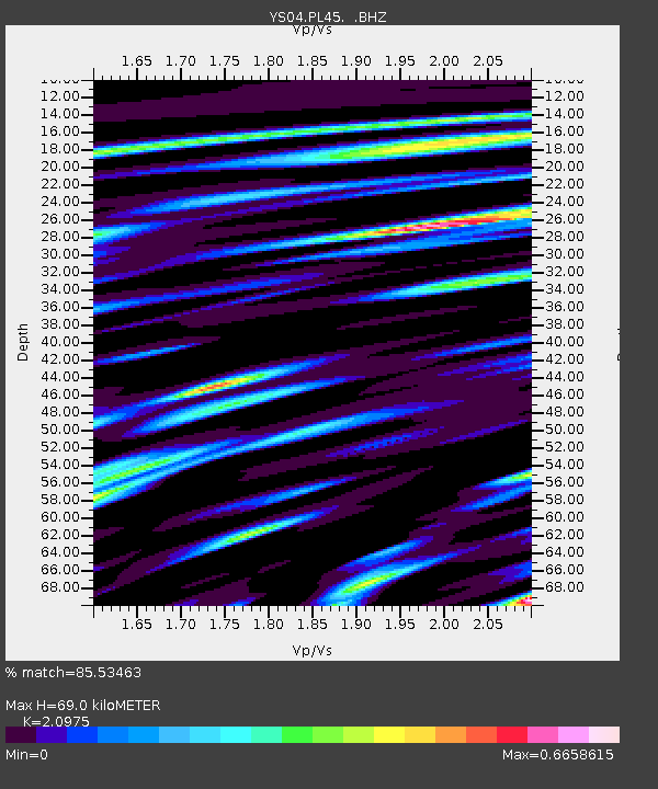
PL45 WHOI OBS ID S03 - Earthquake Result Viewer
| Earthquake location: |
South Of Fiji Islands |
| Earthquake latitude/longitude: |
-25.4/179.7 |
| Earthquake time(UTC): |
2006/11/29 (333) 23:08:15 GMT |
| Earthquake Depth: |
499 km |
| Earthquake Magnitude: |
5.5 MW |
| Earthquake Catalog/Contributor: |
NEIC PDE/NEIC PDE-M |
|
| Network: |
YS Plume Lithosphere Undersea Melt Experiment |
| Station: |
PL45 WHOI OBS ID S03 |
| Lat/Lon: |
24.20 N/154.81 W |
| Elevation: |
-4686.0 m |
|
| Distance: |
55.1 deg |
| Az: |
28.661 deg |
| Baz: |
208.371 deg |
| Ray Param: |
0.06296224 |
| Estimated Moho Depth: |
69.0 km |
| Estimated Crust Vp/Vs: |
2.10 |
| Assumed Crust Vp: |
4.24 km/s |
| Estimated Crust Vs: |
2.021 km/s |
| Estimated Crust Poisson's Ratio: |
0.35 |
|
| Radial Match: |
85.53463 % |
| Radial Bump: |
342 |
| Transverse Match: |
55.546516 % |
| Transverse Bump: |
400 |
| SOD ConfigId: |
590571 |
| Insert Time: |
2013-09-26 04:09:04.620 +0000 |
| GWidth: |
2.5 |
| Max Bumps: |
400 |
| Tol: |
0.001 |
|

Signal To Noise
| Channel | StoN | STA | LTA |
| YS:PL45: :BHZ:20061129T23:16:29.328014Z | 1.0461764 | 7.1702653E-9 | 6.8537815E-9 |
| YS:PL45: :BH1:20061129T23:16:29.328014Z | 0.61992383 | 4.7210813E-9 | 7.615583E-9 |
| YS:PL45: :BH2:20061129T23:16:29.328014Z | 1.0954393 | 9.469549E-9 | 8.6445215E-9 |
| Arrivals |
| Ps | 18 SECOND |
| PpPs | 50 SECOND |
| PsPs/PpSs | 68 SECOND |


