
Station YS PL45 - WHOI OBS ID S03
Network: YS04 - Plume Lithosphere Undersea Melt Experiment
Nearby stations (2 deg radius)
| Station | Name | (Lat, Lon) | Start / End | Elevation |
| PL45 | WHOI OBS ID S03 | (24.20, -154.81) | 2006-04-19 / 2007-05-19 | -4686.0 m |
| Crust2 Type: | A0,normal oceanic, 0.07 km seds. |
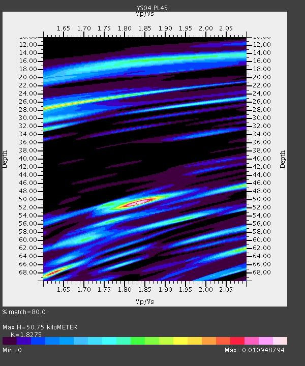
| Thickness Estimate: | 51 km |
| Thickness StdDev: | 17 km |
| Vp/Vs Estimate: | 1.83 |
| Vp/Vs StdDev: | 0.17 |
| Vs Estimate: | 2.32 km/s |
| Poisson's Ratio: | 0.29 |
| Peak Value: | 0.01 |
| Assumed Vp: | 4.24 km/s |
| Ps Weight: | 0.33333334 |
| PpPs Weight: | 0.33333334 |
| PsPs Weight: | 0.33333328 |
| Residual Complexity: | 0.852 |
| Nearby stations H: | +- |
| (2.0 deg) Vp/Vs: | +- |
4 with match > 90% ( 20.0 %) and 7 with match > 80% ( 35.0 %) out of 20.
Download stack as xyz text file.
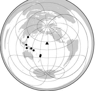
Azimuth Distribution of Events:
Prior Results for this Station
| Study | Thickness | Vp/Vs | Vp | Vs | Poissons Ratio | Extra |
| EARS | 51 km | 1.83 | 4.24 km/s | 2.32 km/s | 0.29 | |
| Crust2.0 | 12 km | 2.19 | 4.24 km/s | 1.94 km/s | 0.37 | A0,normal oceanic, 0.07 km seds. |
| Global Maxima | 51 km | 1.83 | 4.24 km/s | 2.32 km/s | 0.29 | amp=0.010948794 |
| Local Maxima 1 | 68 km | 1.62 | 4.24 km/s | 2.609 km/s | 0.20 | amp=0.00898573 |
| Local Maxima 2 | 28 km | 1.60 | 4.24 km/s | 2.65 km/s | 0.18 | amp=0.007860715 |
| Local Maxima 3 | 62 km | 2.10 | 4.24 km/s | 2.024 km/s | 0.35 | amp=0.007312894 |
| Local Maxima 4 | 32 km | 1.61 | 4.24 km/s | 2.642 km/s | 0.18 | amp=0.0056092995 |
| Predicted Arrivals for vertical incidence (zero ray parameter) | |
| Ps | 9.90 SECOND |
| PpPs | 33.84 SECOND |
| PsPs/PpSs | 43.75 SECOND |
Events Processed for this Station
Download zip of receiver functions as SAC
Plot maxima for each earthquake.
Events Used in the Stack
(7 events)| Radial Match | Distance | Baz | FERegion | Time | Lat/Lon | Depth | Magnitude |
| 99.694405 | 76.7 deg | 288.275 deg | Taiwan Region | 2006/12/27 02:30:36 GMT | (22.0, 120.5) | 10 km | 5.6 MW, 5.5 MW, 5.5 MB |
| 97.38347 | 79.4 deg | 257.578 deg | Banda Sea | 2007/01/23 04:37:19 GMT | (-6.8, 130.0) | 113 km | 5.8 MB, 5.7 MW, 5.6 MW |
| 93.913925 | 79.7 deg | 266.545 deg | Northern Molucca Sea | 2007/01/21 12:32:35 GMT | (1.1, 126.0) | 10 km | 5.5 MB |
| 92.46382 | 63.4 deg | 252.88 deg | Bismarck Sea | 2007/01/22 19:25:49 GMT | (-3.3, 146.4) | 10 km | 5.6 MS, 5.4 MB, 5.8 MW, 5.7 MW |
| 89.27138 | 50.4 deg | 209.426 deg | Fiji Islands Region | 2006/06/02 07:31:36 GMT | (-20.8, -178.7) | 592 km | 5.5 MB, 6.0 MW, 6.0 MW |
| 85.53463 | 55.1 deg | 208.371 deg | South Of Fiji Islands | 2006/11/29 23:08:15 GMT | (-25.4, 179.7) | 499 km | 5.5 MW |
| 81.17404 | 57.4 deg | 243.261 deg | Solomon Islands | 2007/02/17 07:43:33 GMT | (-7.3, 155.9) | 28 km | 5.5 MS, 5.4 MB, 5.7 MW, 5.6 MW |
Losers
(13 events)| Radial Match | Distance | Baz | FERegion | Time | Lat/Lon | Depth | Magnitude | Reason |
| 97.26793 | 45.3 deg | 333.811 deg | Eastern Siberia, Russia | 2006/04/21 04:32:43 GMT | (60.5, 165.8) | 9.0 km | 6.3 MB, 5.6 MS, 6.1 MW, 6.1 ME | |
| 86.41911 | 45.1 deg | 335.451 deg | Eastern Siberia, Russia | 2006/04/21 11:14:15 GMT | (61.4, 167.5) | 12 km | 5.8 MB, 5.8 MS, 6.1 MW, 6.1 MW | |
| 85.44282 | 63.8 deg | 87.383 deg | Off Coast Of Central America | 2006/04/24 21:10:14 GMT | (12.6, -88.1) | 88 km | 5.5 MD | |
| 79.183685 | 94.7 deg | 205.695 deg | West Of Macquarie Island | 2006/09/03 19:44:41 GMT | (-58.8, 149.2) | 10 km | 4.8 MB, 4.8 MS, 5.5 MW | |
| 77.81961 | 84.6 deg | 162.429 deg | Southern East Pacific Rise | 2006/10/10 08:02:51 GMT | (-56.1, -122.4) | 10 km | 5.7 MS, 5.3 MB, 6.0 MW, 5.9 MW | |
| 77.47166 | 58.8 deg | 243.475 deg | Solomon Islands | 2006/05/29 12:12:13 GMT | (-7.9, 154.6) | 27 km | 5.5 MW | |
| 76.55085 | 71.8 deg | 92.911 deg | South Of Panama | 2006/10/18 21:15:49 GMT | (4.8, -82.7) | 20 km | 5.7 MW, 4.9 MS, 5.1 MB, 5.7 MW | |
| 76.36659 | 82.1 deg | 155.184 deg | Southern East Pacific Rise | 2006/10/06 16:25:27 GMT | (-50.1, -114.6) | 10 km | 5.7 MW, 5.4 MS, 4.9 MB | |
| 75.353325 | 79.0 deg | 265.944 deg | Northern Molucca Sea | 2006/07/01 23:15:10 GMT | (0.9, 126.9) | 56 km | 5.5 MW | |
| 57.870018 | 64.4 deg | 296.525 deg | Kyushu, Japan | 2006/06/11 20:01:26 GMT | (33.1, 131.1) | 140 km | 5.9 MB, 6.3 MW, 6.3 MW | |
| 56.576706 | 45.4 deg | 312.943 deg | East Of Kuril Islands | 2006/11/17 06:33:49 GMT | (47.0, 155.5) | 10 km | 5.4 MB, 5.0 MS, 5.6 MW, 5.5 MW | |
| 51.90911 | 54.7 deg | 310.905 deg | Sakhalin, Russia | 2006/08/17 15:20:35 GMT | (46.5, 141.9) | 17 km | 6.0 MB, 5.2 MS, 5.6 MW, 5.5 MW | |
| 45.98691 | 45.4 deg | 312.49 deg | East Of Kuril Islands | 2006/11/28 08:01:51 GMT | (46.7, 155.5) | 10 km | 5.6 MB, 5.2 MW, 5.2 MW |
