You are here: Home > Network List > CN - Canadian National Seismograph Network Stations List
> Station YKW4 YKW4, NT, CANADA > Earthquake Result Viewer
YKW4 YKW4, NT, CANADA - Earthquake Result Viewer

| Earthquake location: |
Gulf Of California |
| Earthquake latitude/longitude: |
28.2/-112.1 |
| Earthquake time(UTC): |
2006/01/04 (004) 08:32:32 GMT |
| Earthquake Depth: |
14 km |
| Earthquake Magnitude: |
6.1 MB, 6.7 MS, 6.6 MW, 6.5 MW |
| Earthquake Catalog/Contributor: |
WHDF/NEIC |
|
| Network: |
CN Canadian National Seismograph Network |
| Station: |
YKW4 YKW4, NT, CANADA |
| Lat/Lon: |
62.49 N/114.74 W |
| Elevation: |
161 m |
|
| Distance: |
34.4 deg |
| Az: |
357.841 deg |
| Baz: |
175.891 deg |
| Ray Param: |
0.0777653 |
| Estimated Moho Depth: |
37.5 km |
| Estimated Crust Vp/Vs: |
1.87 |
| Assumed Crust Vp: |
6.459 km/s |
| Estimated Crust Vs: |
3.454 km/s |
| Estimated Crust Poisson's Ratio: |
0.30 |
|
| Radial Match: |
89.73242 % |
| Radial Bump: |
304 |
| Transverse Match: |
54.55427 % |
| Transverse Bump: |
337 |
| SOD ConfigId: |
5423 |
| Insert Time: |
2010-02-27 08:33:29.904 +0000 |
| GWidth: |
2.5 |
| Max Bumps: |
400 |
| Tol: |
0.001 |
|
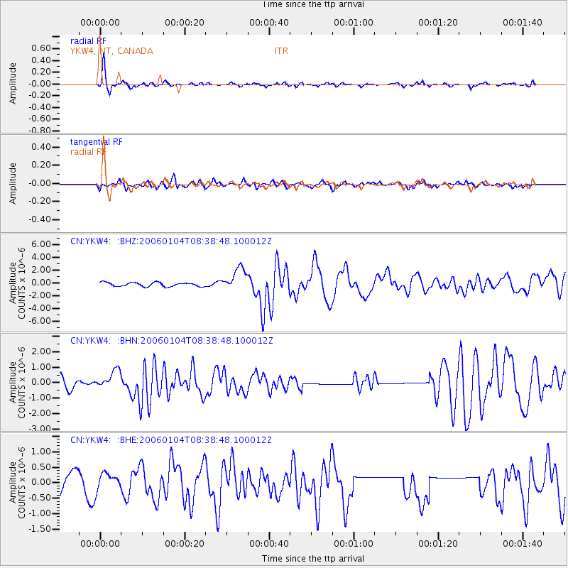
Signal To Noise
| Channel | StoN | STA | LTA |
| CN:YKW4: :BHN:20060104T08:38:48.100012Z | 2.3409693 | 6.260375E-7 | 2.6742663E-7 |
| CN:YKW4: :BHE:20060104T08:38:48.100012Z | 0.5186298 | 2.5198625E-7 | 4.8586924E-7 |
| CN:YKW4: :BHZ:20060104T08:38:48.100012Z | 5.969896 | 1.8701272E-6 | 3.1325962E-7 |
| Arrivals |
| Ps | 5.4 SECOND |
| PpPs | 15 SECOND |
| PsPs/PpSs | 21 SECOND |


