
Station CN YKW4 - YKW4, NT, CANADA
Network: CN - Canadian National Seismograph Network
Nearby stations (2 deg radius)
| Station | Name | (Lat, Lon) | Start / End | Elevation |
| YKW4 | YKW4, NT, CANADA | (62.49, -114.74) | 1989-01-25 / 2499-01-01 | 0.2 km |
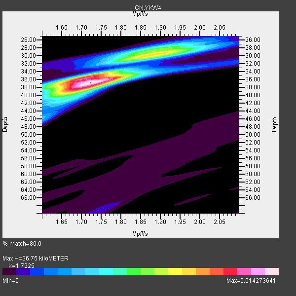
| Crust2 Type: | G1,Archean, no seds. |
| Thickness Estimate: | 37 km |
| Thickness StdDev: | 2.8 km |
| Vp/Vs Estimate: | 1.72 |
| Vp/Vs StdDev: | 0.07 |
| Vs Estimate: | 3.75 km/s |
| Poisson's Ratio: | 0.25 |
| Peak Value: | 0.01 |
| Assumed Vp: | 6.459 km/s |
| Ps Weight: | 0.33333334 |
| PpPs Weight: | 0.33333334 |
| PsPs Weight: | 0.33333328 |
| Residual Complexity: | 0.602 |
| Nearby stations H: | +- |
| (2.0 deg) Vp/Vs: | +- |
7 with match > 90% ( 30.434782 %) and 20 with match > 80% ( 86.95652 %) out of 23.
Download stack as xyz text file.
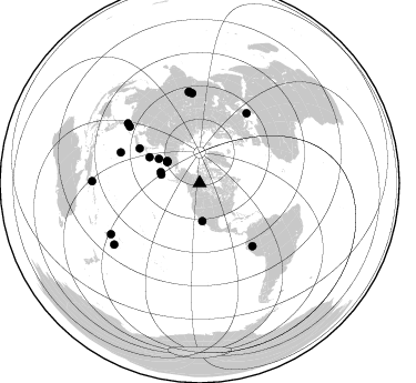
Azimuth Distribution of Events:
Prior Results for this Station
| Study | Thickness | Vp/Vs | Vp | Vs | Poissons Ratio | Extra |
| EARS | 37 km | 1.72 | 6.459 km/s | 3.75 km/s | 0.25 | |
| Crust2.0 | 37 km | 1.76 | 6.459 km/s | 3.665 km/s | 0.26 | G1,Archean, no seds. |
| Global Maxima | 37 km | 1.72 | 6.459 km/s | 3.75 km/s | 0.25 | amp=0.014273641 |
| Local Maxima 1 | 30 km | 1.88 | 6.459 km/s | 3.431 km/s | 0.30 | amp=0.009510536 |
| Local Maxima 2 | 36 km | 1.69 | 6.459 km/s | 3.834 km/s | 0.23 | amp=0.008575375 |
| Local Maxima 3 | 38 km | 1.70 | 6.459 km/s | 3.811 km/s | 0.23 | amp=0.005546826 |
| Local Maxima 4 | 28 km | 1.89 | 6.459 km/s | 3.418 km/s | 0.31 | amp=0.00483598 |
| Predicted Arrivals for vertical incidence (zero ray parameter) | |
| Ps | 4.11 SECOND |
| PpPs | 15.49 SECOND |
| PsPs/PpSs | 19.60 SECOND |
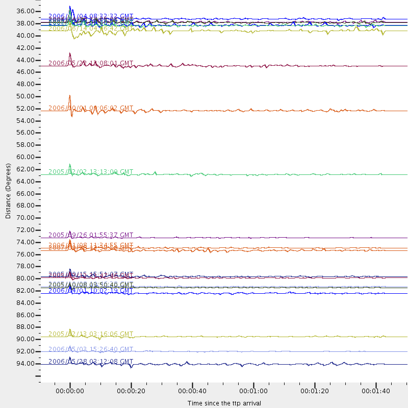
Events Processed for this Station
Download zip of receiver functions as SAC
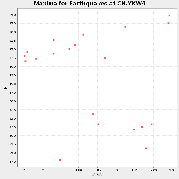
Plot maxima for each earthquake.
Events Used in the Stack
(20 events)| Radial Match | Distance | Baz | FERegion | Time | Lat/Lon | Depth | Magnitude |
| 98.8287 | 74.0 deg | 140.043 deg | Northern Peru | 2005/09/26 01:55:37 GMT | (-5.7, -76.4) | 115 km | 6.7 MB, 7.5 MW, 7.5 MW |
| 96.073654 | 81.4 deg | 355.238 deg | Afghanistan-Tajikistan Bord Reg. | 2005/12/12 21:47:46 GMT | (36.4, 71.1) | 225 km | 6.0 MB, 6.5 MW, 6.5 MW |
| 95.407455 | 83.1 deg | 353.079 deg | Pakistan | 2005/10/08 03:50:40 GMT | (34.5, 73.6) | 26 km | 6.9 MB, 7.7 MS, 7.6 MW, 7.3 MW |
| 93.57704 | 75.9 deg | 33.9 deg | Southern Greece | 2006/01/08 11:34:55 GMT | (36.3, 23.2) | 66 km | 6.5 MB, 6.7 MW, 6.7 MW |
| 93.32583 | 94.7 deg | 234.199 deg | Tonga Islands | 2006/05/03 15:26:40 GMT | (-20.2, -174.1) | 55 km | 7.2 MB, 7.8 MS, 7.9 MW, 7.9 MW |
| 91.75714 | 62.6 deg | 300.022 deg | Near East Coast Of Honshu, Japan | 2005/12/02 13:13:09 GMT | (38.1, 142.1) | 29 km | 6.1 MB, 6.3 MS, 6.5 MW, 6.4 MW |
| 91.143 | 82.9 deg | 353.497 deg | Pakistan | 2005/10/08 10:46:28 GMT | (34.7, 73.1) | 8.0 km | 6.0 MB, 6.3 MS, 6.4 MW, 6.2 MW |
| 89.77972 | 35.6 deg | 303.995 deg | Eastern Siberia, Russia | 2006/05/22 11:12:00 GMT | (60.8, 165.7) | 16 km | 6.0 MB, 6.7 MS, 6.6 MW, 6.5 MW |
| 89.73242 | 34.4 deg | 175.891 deg | Gulf Of California | 2006/01/04 08:32:32 GMT | (28.2, -112.1) | 14 km | 6.1 MB, 6.7 MS, 6.6 MW, 6.5 MW |
| 89.43999 | 81.1 deg | 308.95 deg | Northeast Of Taiwan | 2005/10/15 15:51:07 GMT | (25.3, 123.4) | 183 km | 6.2 MB, 6.5 MW, 6.5 MW |
| 89.43388 | 35.0 deg | 303.535 deg | Eastern Siberia, Russia | 2006/04/20 23:25:02 GMT | (60.9, 167.1) | 22 km | 6.8 MB, 7.6 MS, 7.6 MW, 7.3 MW |
| 87.75223 | 36.6 deg | 285.609 deg | Rat Islands, Aleutian Islands | 2006/06/14 04:46:42 GMT | (51.9, 177.1) | 29 km | 5.5 MB, 5.9 MW, 5.7 ML |
| 87.33314 | 35.5 deg | 282.44 deg | Andreanof Islands, Aleutian Is. | 2007/12/19 09:30:27 GMT | (51.4, -179.5) | 29 km | 6.4 MB, 7.1 MS, 7.1 MW, 7.0 MW |
| 86.7349 | 84.1 deg | 309.743 deg | Taiwan Region | 2006/04/01 10:02:19 GMT | (22.9, 121.3) | 9.0 km | 6.0 MB, 6.1 MS, 6.2 MW, 6.1 MW |
| 86.3882 | 96.9 deg | 271.003 deg | New Britain Region, P.N.G. | 2006/05/28 03:12:08 GMT | (-5.7, 151.1) | 34 km | 5.9 MB, 6.6 MS, 6.5 MW, 6.4 MW |
| 86.02972 | 35.1 deg | 302.678 deg | Eastern Siberia, Russia | 2006/04/29 16:58:06 GMT | (60.5, 167.5) | 11 km | 6.4 MB, 6.6 MS, 6.6 MW, 6.4 MW |
| 85.91152 | 42.9 deg | 300.677 deg | Kamchatka Peninsula, Russia | 2006/05/22 13:08:01 GMT | (54.3, 158.4) | 185 km | 6.2 MB, 6.2 MW, 6.2 MW |
| 83.894226 | 51.0 deg | 297.338 deg | Kuril Islands | 2006/10/01 09:06:02 GMT | (46.5, 153.2) | 19 km | 6.1 MB, 6.4 MS, 6.6 MW, 6.5 MW |
| 81.55562 | 76.4 deg | 291.258 deg | Volcano Islands, Japan Region | 2007/09/28 13:38:59 GMT | (22.0, 142.7) | 276 km | 6.7 MB, 7.4 MW, 7.4 MW |
| 81.46128 | 92.0 deg | 240.079 deg | Fiji Islands Region | 2005/12/13 03:16:06 GMT | (-15.3, -178.6) | 10 km | 6.1 MB, 6.8 MS, 6.7 MW, 6.7 MW |
Losers
(3 events)| Radial Match | Distance | Baz | FERegion | Time | Lat/Lon | Depth | Magnitude | Reason |
| 64.48202 | 91.2 deg | 302.194 deg | Philippine Islands Region | 2008/03/03 14:11:14 GMT | (13.4, 125.6) | 24 km | 6.4 MB, 6.9 MW, 6.8 MW | |
| 60.224384 | 51.1 deg | 297.336 deg | Kuril Islands | 2008/03/03 09:31:02 GMT | (46.4, 153.2) | 10 km | 6.2 MB, 6.5 MS, 6.5 MW, 6.5 MW | |
| 16.873968 | 86.8 deg | 308.555 deg | Philippine Islands Region | 2008/03/03 13:49:40 GMT | (19.9, 121.3) | 10 km | 6.0 MB, 6.0 MW, 5.9 MW |
