You are here: Home > Network List > CN - Canadian National Seismograph Network Stations List
> Station YKW4 YKW4, NT, CANADA > Earthquake Result Viewer
YKW4 YKW4, NT, CANADA - Earthquake Result Viewer
| Earthquake location: |
Kuril Islands |
| Earthquake latitude/longitude: |
46.5/153.2 |
| Earthquake time(UTC): |
2006/10/01 (274) 09:06:02 GMT |
| Earthquake Depth: |
19 km |
| Earthquake Magnitude: |
6.1 MB, 6.4 MS, 6.6 MW, 6.5 MW |
| Earthquake Catalog/Contributor: |
WHDF/NEIC |
|
| Network: |
CN Canadian National Seismograph Network |
| Station: |
YKW4 YKW4, NT, CANADA |
| Lat/Lon: |
62.49 N/114.74 W |
| Elevation: |
161 m |
|
| Distance: |
51.0 deg |
| Az: |
36.637 deg |
| Baz: |
297.338 deg |
| Ray Param: |
0.067641385 |
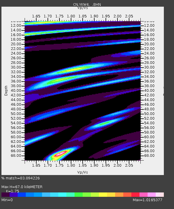
| Estimated Moho Depth: |
67.0 km |
| Estimated Crust Vp/Vs: |
1.75 |
| Assumed Crust Vp: |
6.459 km/s |
| Estimated Crust Vs: |
3.691 km/s |
| Estimated Crust Poisson's Ratio: |
0.26 |
|
| Radial Match: |
83.894226 % |
| Radial Bump: |
400 |
| Transverse Match: |
80.384895 % |
| Transverse Bump: |
400 |
| SOD ConfigId: |
2665 |
| Insert Time: |
2010-02-27 08:33:30.984 +0000 |
| GWidth: |
2.5 |
| Max Bumps: |
400 |
| Tol: |
0.001 |
|
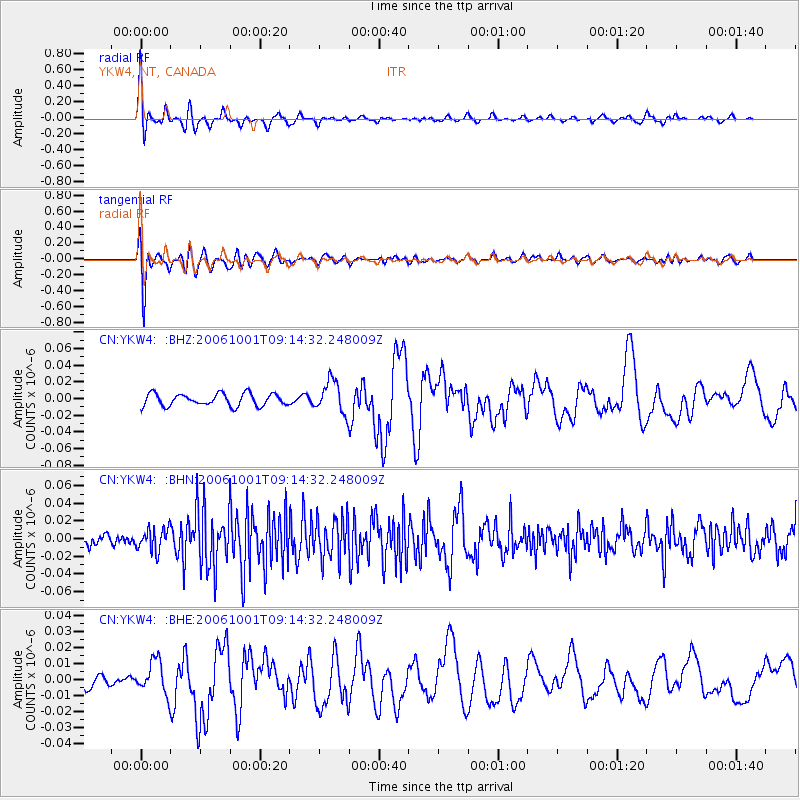
Signal To Noise
| Channel | StoN | STA | LTA |
| CN:YKW4: :BHN:20061001T09:14:32.248009Z | 1.695279 | 1.2867598E-8 | 7.590254E-9 |
| CN:YKW4: :BHE:20061001T09:14:32.248009Z | 2.5261953 | 1.05068265E-8 | 4.1591504E-9 |
| CN:YKW4: :BHZ:20061001T09:14:32.248009Z | 2.6067436 | 1.919159E-8 | 7.3622854E-9 |
| Arrivals |
| Ps | 8.2 SECOND |
| PpPs | 27 SECOND |
| PsPs/PpSs | 35 SECOND |


