You are here: Home > Network List > CN - Canadian National Seismograph Network Stations List
> Station YKW4 YKW4, NT, CANADA > Earthquake Result Viewer
YKW4 YKW4, NT, CANADA - Earthquake Result Viewer
| Earthquake location: |
Afghanistan-Tajikistan Bord Reg. |
| Earthquake latitude/longitude: |
36.4/71.1 |
| Earthquake time(UTC): |
2005/12/12 (346) 21:47:46 GMT |
| Earthquake Depth: |
225 km |
| Earthquake Magnitude: |
6.0 MB, 6.5 MW, 6.5 MW |
| Earthquake Catalog/Contributor: |
WHDF/NEIC |
|
| Network: |
CN Canadian National Seismograph Network |
| Station: |
YKW4 YKW4, NT, CANADA |
| Lat/Lon: |
62.49 N/114.74 W |
| Elevation: |
161 m |
|
| Distance: |
81.4 deg |
| Az: |
2.737 deg |
| Baz: |
355.238 deg |
| Ray Param: |
0.04706082 |
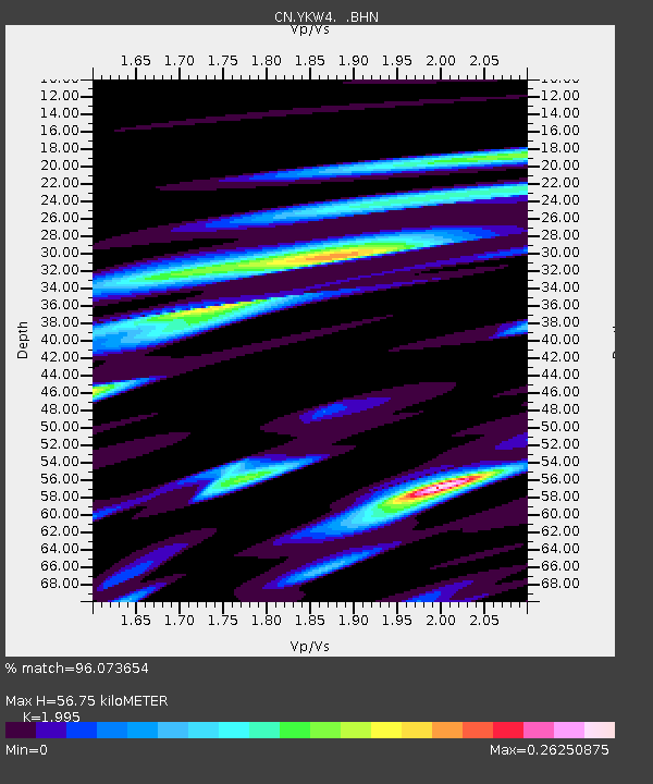
| Estimated Moho Depth: |
56.75 km |
| Estimated Crust Vp/Vs: |
2.00 |
| Assumed Crust Vp: |
6.459 km/s |
| Estimated Crust Vs: |
3.238 km/s |
| Estimated Crust Poisson's Ratio: |
0.33 |
|
| Radial Match: |
96.073654 % |
| Radial Bump: |
334 |
| Transverse Match: |
75.09288 % |
| Transverse Bump: |
400 |
| SOD ConfigId: |
2564 |
| Insert Time: |
2010-02-27 08:33:55.760 +0000 |
| GWidth: |
2.5 |
| Max Bumps: |
400 |
| Tol: |
0.001 |
|

Signal To Noise
| Channel | StoN | STA | LTA |
| CN:YKW4: :BHN:20051212T21:59:06.450005Z | 16.64458 | 2.9127225E-8 | 1.7499524E-9 |
| CN:YKW4: :BHE:20051212T21:59:06.450005Z | 1.08775 | 3.5312955E-9 | 3.2464222E-9 |
| CN:YKW4: :BHZ:20051212T21:59:06.450005Z | 34.29778 | 1.1433638E-7 | 3.3336383E-9 |
| Arrivals |
| Ps | 9.0 SECOND |
| PpPs | 26 SECOND |
| PsPs/PpSs | 35 SECOND |


