You are here: Home > Network List > CN - Canadian National Seismograph Network Stations List
> Station YKW4 YKW4, NT, CANADA > Earthquake Result Viewer
YKW4 YKW4, NT, CANADA - Earthquake Result Viewer
| Earthquake location: |
Northeast Of Taiwan |
| Earthquake latitude/longitude: |
25.3/123.4 |
| Earthquake time(UTC): |
2005/10/15 (288) 15:51:07 GMT |
| Earthquake Depth: |
183 km |
| Earthquake Magnitude: |
6.2 MB, 6.5 MW, 6.5 MW |
| Earthquake Catalog/Contributor: |
WHDF/NEIC |
|
| Network: |
CN Canadian National Seismograph Network |
| Station: |
YKW4 YKW4, NT, CANADA |
| Lat/Lon: |
62.49 N/114.74 W |
| Elevation: |
161 m |
|
| Distance: |
81.1 deg |
| Az: |
23.515 deg |
| Baz: |
308.95 deg |
| Ray Param: |
0.047368936 |
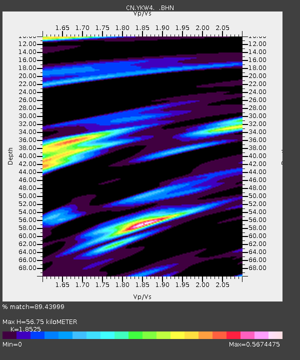
| Estimated Moho Depth: |
56.75 km |
| Estimated Crust Vp/Vs: |
1.85 |
| Assumed Crust Vp: |
6.459 km/s |
| Estimated Crust Vs: |
3.487 km/s |
| Estimated Crust Poisson's Ratio: |
0.29 |
|
| Radial Match: |
89.43999 % |
| Radial Bump: |
333 |
| Transverse Match: |
76.8856 % |
| Transverse Bump: |
400 |
| SOD ConfigId: |
2564 |
| Insert Time: |
2010-02-27 08:34:00.312 +0000 |
| GWidth: |
2.5 |
| Max Bumps: |
400 |
| Tol: |
0.001 |
|

Signal To Noise
| Channel | StoN | STA | LTA |
| CN:YKW4: :BHN:20051015T16:02:30.850015Z | 6.2895107 | 1.07804325E-8 | 1.7140337E-9 |
| CN:YKW4: :BHE:20051015T16:02:30.850015Z | 6.996031 | 1.9642268E-8 | 2.8076304E-9 |
| CN:YKW4: :BHZ:20051015T16:02:30.850015Z | 15.8323145 | 7.352946E-8 | 4.644265E-9 |
| Arrivals |
| Ps | 7.7 SECOND |
| PpPs | 24 SECOND |
| PsPs/PpSs | 32 SECOND |


