You are here: Home > Network List > CN - Canadian National Seismograph Network Stations List
> Station YKW4 YKW4, NT, CANADA > Earthquake Result Viewer
YKW4 YKW4, NT, CANADA - Earthquake Result Viewer
| Earthquake location: |
Northern Peru |
| Earthquake latitude/longitude: |
-5.7/-76.4 |
| Earthquake time(UTC): |
2005/09/26 (269) 01:55:37 GMT |
| Earthquake Depth: |
115 km |
| Earthquake Magnitude: |
6.7 MB, 7.5 MW, 7.5 MW |
| Earthquake Catalog/Contributor: |
WHDF/NEIC |
|
| Network: |
CN Canadian National Seismograph Network |
| Station: |
YKW4 YKW4, NT, CANADA |
| Lat/Lon: |
62.49 N/114.74 W |
| Elevation: |
161 m |
|
| Distance: |
74.0 deg |
| Az: |
342.564 deg |
| Baz: |
140.043 deg |
| Ray Param: |
0.052333206 |
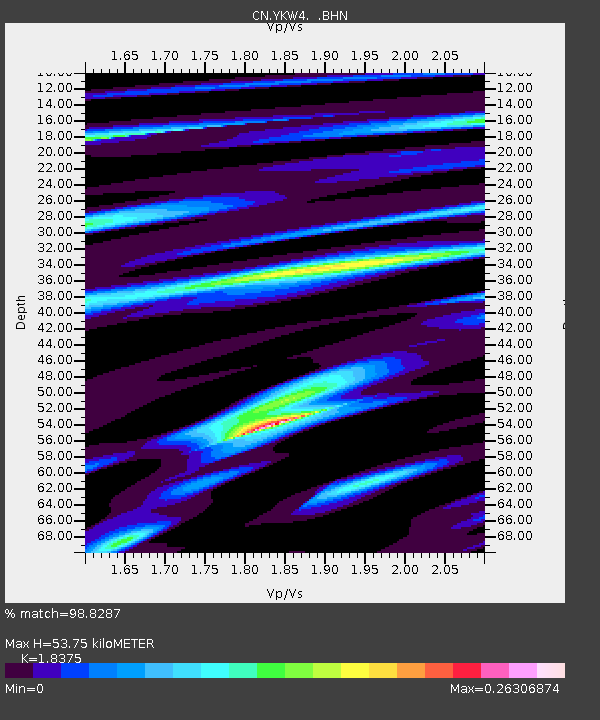
| Estimated Moho Depth: |
53.75 km |
| Estimated Crust Vp/Vs: |
1.84 |
| Assumed Crust Vp: |
6.459 km/s |
| Estimated Crust Vs: |
3.515 km/s |
| Estimated Crust Poisson's Ratio: |
0.29 |
|
| Radial Match: |
98.8287 % |
| Radial Bump: |
344 |
| Transverse Match: |
98.38086 % |
| Transverse Bump: |
400 |
| SOD ConfigId: |
2564 |
| Insert Time: |
2010-02-27 08:34:06.814 +0000 |
| GWidth: |
2.5 |
| Max Bumps: |
400 |
| Tol: |
0.001 |
|

Signal To Noise
| Channel | StoN | STA | LTA |
| CN:YKW4: :BHN:20050926T02:06:29.899004Z | 20.931236 | 2.7766689E-8 | 1.3265671E-9 |
| CN:YKW4: :BHE:20050926T02:06:29.899004Z | 36.00601 | 1.6374342E-7 | 4.5476694E-9 |
| CN:YKW4: :BHZ:20050926T02:06:29.899004Z | 53.88505 | 5.6774354E-7 | 1.0536197E-8 |
| Arrivals |
| Ps | 7.2 SECOND |
| PpPs | 23 SECOND |
| PsPs/PpSs | 30 SECOND |


