You are here: Home > Network List > ZD07 - Seismcity of Quebrada-Discovery-gofur- Transforms ( QDG) Stations List
> Station G16 WHOI OBS ID S74 > Earthquake Result Viewer
G16 WHOI OBS ID S74 - Earthquake Result Viewer
| Earthquake location: |
Southern Mid-Atlantic Ridge |
| Earthquake latitude/longitude: |
-47.4/-12.2 |
| Earthquake time(UTC): |
2008/07/15 (197) 05:07:11 GMT |
| Earthquake Depth: |
10 km |
| Earthquake Magnitude: |
5.7 MW, 5.3 MS, 5.2 MB |
| Earthquake Catalog/Contributor: |
WHDF/NEIC |
|
| Network: |
ZD Seismcity of Quebrada-Discovery-gofur- Transforms ( QDG) |
| Station: |
G16 WHOI OBS ID S74 |
| Lat/Lon: |
4.72 S/105.58 W |
| Elevation: |
-2961.0 m |
|
| Distance: |
88.9 deg |
| Az: |
264.314 deg |
| Baz: |
137.258 deg |
| Ray Param: |
0.042257562 |
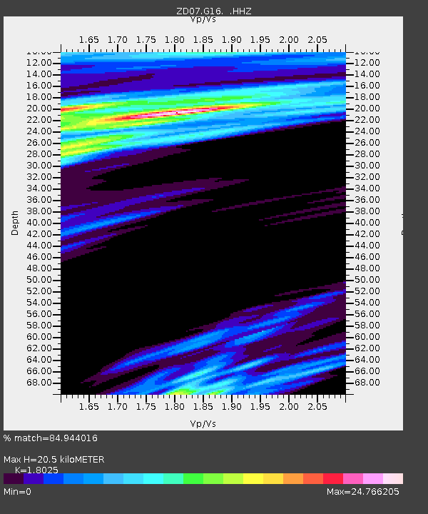
| Estimated Moho Depth: |
20.5 km |
| Estimated Crust Vp/Vs: |
1.80 |
| Assumed Crust Vp: |
4.24 km/s |
| Estimated Crust Vs: |
2.352 km/s |
| Estimated Crust Poisson's Ratio: |
0.28 |
|
| Radial Match: |
84.944016 % |
| Radial Bump: |
400 |
| Transverse Match: |
66.739655 % |
| Transverse Bump: |
400 |
| SOD ConfigId: |
590571 |
| Insert Time: |
2013-09-27 01:31:00.463 +0000 |
| GWidth: |
2.5 |
| Max Bumps: |
400 |
| Tol: |
0.001 |
|

Signal To Noise
| Channel | StoN | STA | LTA |
| ZD:G16: :HHZ:20080715T05:19:34.686987Z | 0.96521485 | 1.4541489E-6 | 1.5065546E-6 |
| ZD:G16: :HH1:20080715T05:19:34.686987Z | 2.5072787 | 2.2048274E-5 | 8.793708E-6 |
| ZD:G16: :HH2:20080715T05:19:34.686987Z | 3.963629 | 2.3056107E-5 | 5.816919E-6 |
| Arrivals |
| Ps | 3.9 SECOND |
| PpPs | 13 SECOND |
| PsPs/PpSs | 17 SECOND |


