
Station ZD G16 - WHOI OBS ID S74
Network: ZD07 - Seismcity of Quebrada-Discovery-gofur- Transforms ( QDG)
Nearby stations (2 deg radius)
| Station | Name | (Lat, Lon) | Start / End | Elevation |
| G16 | WHOI OBS ID S74 | (-4.72, -105.58) | 2007-12-25 / 2009-01-21 | -2961.0 m |
| Crust2 Type: | A0,normal oceanic, 0.07 km seds. |
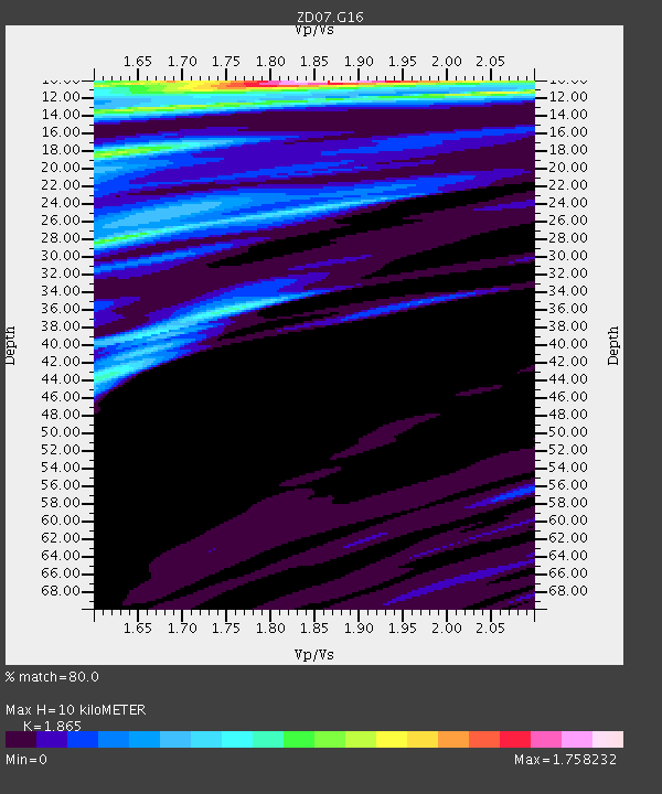
| Thickness Estimate: | 10 km |
| Thickness StdDev: | 4.5 km |
| Vp/Vs Estimate: | 1.87 |
| Vp/Vs StdDev: | 0.10 |
| Vs Estimate: | 2.273 km/s |
| Poisson's Ratio: | 0.30 |
| Peak Value: | 1.76 |
| Assumed Vp: | 4.24 km/s |
| Ps Weight: | 0.33333334 |
| PpPs Weight: | 0.33333334 |
| PsPs Weight: | 0.33333328 |
| Residual Complexity: | 0.738 |
| Nearby stations H: | +- |
| (2.0 deg) Vp/Vs: | +- |
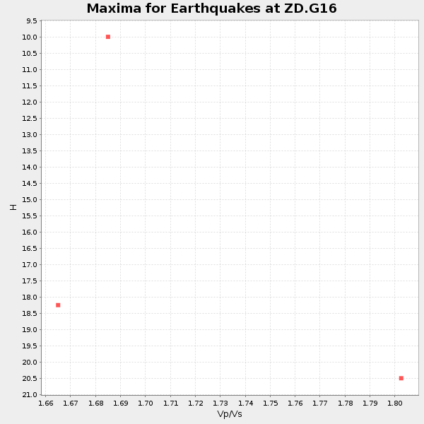
0 with match > 90% ( 0.0 %) and 3 with match > 80% ( 5.357143 %) out of 56.
Download stack as xyz text file.
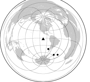
Azimuth Distribution of Events:
Prior Results for this Station
| Study | Thickness | Vp/Vs | Vp | Vs | Poissons Ratio | Extra |
| EARS | 10 km | 1.87 | 4.24 km/s | 2.273 km/s | 0.30 | |
| Crust2.0 | 12 km | 2.19 | 4.24 km/s | 1.94 km/s | 0.37 | A0,normal oceanic, 0.07 km seds. |
| Global Maxima | 10 km | 1.87 | 4.24 km/s | 2.273 km/s | 0.30 | amp=1.758232 |
| Local Maxima 1 | 11 km | 2.06 | 4.24 km/s | 2.056 km/s | 0.35 | amp=1.102056 |
| Local Maxima 2 | 18 km | 1.63 | 4.24 km/s | 2.601 km/s | 0.20 | amp=0.93544906 |
| Local Maxima 3 | 28 km | 1.62 | 4.24 km/s | 2.625 km/s | 0.19 | amp=0.8890494 |
| Local Maxima 4 | 10 km | 1.69 | 4.24 km/s | 2.516 km/s | 0.23 | amp=0.86412877 |
| Predicted Arrivals for vertical incidence (zero ray parameter) | |
| Ps | 2.04 SECOND |
| PpPs | 6.76 SECOND |
| PsPs/PpSs | 8.80 SECOND |
Events Processed for this Station
Download zip of receiver functions as SAC
Plot maxima for each earthquake.
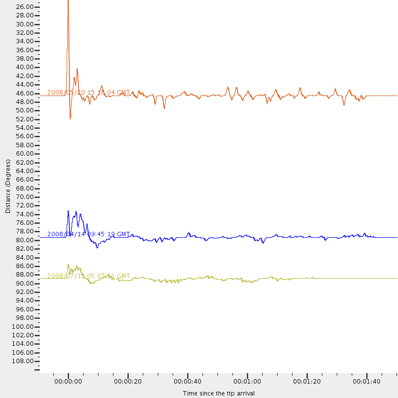
Events Used in the Stack
(3 events)| Radial Match | Distance | Baz | FERegion | Time | Lat/Lon | Depth | Magnitude |
| 88.37849 | 79.1 deg | 146.066 deg | South Sandwich Islands Region | 2008/04/14 09:45:19 GMT | (-56.0, -28.0) | 140 km | 6.0 MB, 6.0 MW, 6.0 MW |
| 88.17519 | 46.3 deg | 152.901 deg | Off Coast Of Southern Chile | 2008/05/20 15:16:04 GMT | (-44.5, -78.2) | 10 km | 5.6 MW |
| 84.944016 | 88.9 deg | 137.258 deg | Southern Mid-Atlantic Ridge | 2008/07/15 05:07:11 GMT | (-47.4, -12.2) | 10 km | 5.7 MW, 5.3 MS, 5.2 MB |
Losers
(53 events)| Radial Match | Distance | Baz | FERegion | Time | Lat/Lon | Depth | Magnitude | Reason |
| 95.21007 | 84.3 deg | 249.53 deg | Loyalty Islands | 2008/07/09 08:24:16 GMT | (-20.9, 168.8) | 39 km | 5.6 MB, 4.9 MS, 5.4 MW | |
| 92.509735 | 53.3 deg | 338.872 deg | Off Coast Of Oregon | 2008/07/17 22:36:18 GMT | (44.4, -129.4) | 10 km | 5.5 MW, 5.0 MS, 5.1 MB, 5.5 MW | |
| 91.595024 | 97.9 deg | 320.66 deg | Kuril Islands | 2008/07/24 01:43:16 GMT | (51.0, 157.6) | 27 km | 6.0 MB, 6.0 MS, 6.2 MW, 6.2 MW | |
| 90.60982 | 31.6 deg | 350.725 deg | Gulf Of California | 2008/08/07 02:18:13 GMT | (26.6, -111.0) | 10 km | 5.5 MW | |
| 90.198875 | 69.9 deg | 251.916 deg | Tonga Islands | 2008/04/15 17:24:56 GMT | (-18.7, -176.0) | 10 km | 5.5 MB, 5.5 MS, 5.7 MW, 5.6 MW | |
| 90.01338 | 91.1 deg | 208.966 deg | West Of Macquarie Island | 2008/08/09 06:01:48 GMT | (-60.6, 153.8) | 10 km | 5.6 MB, 5.9 MS, 6.5 MW, 6.4 MW | |
| 79.93137 | 53.4 deg | 338.827 deg | Off Coast Of Oregon | 2008/07/17 22:51:55 GMT | (44.4, -129.4) | 10 km | 5.6 MB, 5.3 MS, 5.7 MW, 5.6 MW | |
| 79.24117 | 50.7 deg | 339.713 deg | Off Coast Of Oregon | 2008/03/15 14:44:36 GMT | (42.4, -126.8) | 10 km | 5.5 MS, 5.3 MB, 5.7 MW, 5.7 MW | |
| 78.80461 | 78.1 deg | 325.588 deg | Fox Islands, Aleutian Islands | 2008/03/11 14:37:10 GMT | (52.2, -169.5) | 16 km | 5.5 MB, 5.3 MS, 5.6 MW, 5.5 MW | |
| 77.63615 | 79.8 deg | 149.708 deg | South Sandwich Islands Region | 2008/07/30 20:15:11 GMT | (-59.6, -27.8) | 136 km | 5.6 MB, 5.6 MW, 5.5 MW | |
| 74.70046 | 51.0 deg | 189.813 deg | Southern East Pacific Rise | 2008/07/29 20:56:22 GMT | (-54.7, -118.8) | 10 km | 5.5 MB, 5.4 MS, 5.8 MW, 5.7 MW | |
| 72.44327 | 73.6 deg | 247.146 deg | South Of Fiji Islands | 2008/07/03 03:02:37 GMT | (-23.4, -179.8) | 581 km | 5.6 MB, 6.2 MW, 6.2 MW | |
| 69.78189 | 81.0 deg | 148.627 deg | South Sandwich Islands Region | 2008/01/29 14:57:26 GMT | (-58.7, -25.2) | 35 km | 5.6 MW, 5.6 MW | |
| 65.53133 | 85.3 deg | 252.298 deg | Vanuatu Islands | 2008/06/10 04:13:37 GMT | (-18.1, 167.9) | 35 km | 5.7 MS, 5.3 MB, 5.9 MW, 5.8 MW | |
| 64.17618 | 97.7 deg | 262.14 deg | Solomon Islands | 2008/05/24 13:24:05 GMT | (-7.2, 156.1) | 29 km | 5.8 MB, 5.5 MS, 5.9 MW, 5.8 MW | |
| 63.66786 | 88.9 deg | 259.058 deg | Santa Cruz Islands Region | 2008/07/19 11:01:17 GMT | (-11.1, 164.6) | 10 km | 5.8 MB, 5.9 MS, 6.2 MW, 6.2 MW | |
| 62.505157 | 73.4 deg | 248.577 deg | Fiji Islands Region | 2008/01/15 17:52:15 GMT | (-22.0, -179.5) | 598 km | 5.8 MB, 6.5 MW, 6.5 MW | |
| 62.364613 | 69.2 deg | 248.1 deg | Tonga Islands Region | 2008/03/14 16:02:22 GMT | (-22.3, -175.0) | 35 km | 5.5 MS | |
| 61.653168 | 84.3 deg | 250.213 deg | Loyalty Islands | 2008/04/28 20:26:53 GMT | (-20.2, 168.8) | 35 km | 5.8 MB, 5.7 MS, 6.1 MW, 6.0 MW | |
| 61.375095 | 95.6 deg | 146.052 deg | Bouvet Island Region | 2008/05/30 10:44:11 GMT | (-54.7, 1.0) | 10 km | 5.7 MW, 5.7 MW | |
| 60.604572 | 91.1 deg | 208.927 deg | West Of Macquarie Island | 2008/08/09 16:36:38 GMT | (-60.7, 153.8) | 10 km | 5.7 MB, 6.0 MS, 6.3 MW, 6.3 MW | |
| 59.5432 | 86.1 deg | 253.428 deg | Vanuatu Islands | 2008/03/24 07:02:34 GMT | (-16.9, 167.0) | 10 km | 5.5 MW | |
| 59.1457 | 68.0 deg | 146.023 deg | South Atlantic Ocean | 2008/02/20 12:49:44 GMT | (-53.0, -46.5) | 10 km | 5.6 MB | |
| 56.430443 | 84.2 deg | 250.134 deg | Loyalty Islands | 2008/04/10 04:29:35 GMT | (-20.3, 168.9) | 35 km | 5.5 MW | |
| 52.89056 | 81.8 deg | 147.119 deg | South Sandwich Islands Region | 2008/02/23 15:57:19 GMT | (-57.3, -23.4) | 10 km | 6.2 MB, 6.7 MS, 6.7 MW, 6.7 MW | |
| 49.985466 | 84.3 deg | 250.176 deg | Loyalty Islands | 2008/04/19 05:58:42 GMT | (-20.3, 168.8) | 14 km | 5.7 MB, 6.2 MS, 6.3 MW, 6.2 MW | |
| 48.882725 | 84.2 deg | 250.383 deg | Loyalty Islands | 2008/04/09 12:46:12 GMT | (-20.1, 168.9) | 33 km | 6.3 MB, 7.3 MS, 7.3 MW, 7.3 MW | |
| 46.86912 | 84.2 deg | 250.277 deg | Loyalty Islands | 2008/04/09 11:13:17 GMT | (-20.2, 168.9) | 13 km | 5.6 MB, 6.3 MS, 6.4 MW, 6.3 MW | |
| 46.281303 | 37.8 deg | 117.07 deg | Near Coast Of Northern Chile | 2008/02/04 17:01:30 GMT | (-20.2, -70.0) | 44 km | 6.0 MB, 6.2 MS, 6.3 MW, 6.3 MW | |
| 43.653717 | 67.6 deg | 249.585 deg | Tonga Islands | 2008/06/26 21:19:15 GMT | (-20.8, -173.3) | 38 km | 6.0 MB, 5.8 MS, 6.2 MW, 6.1 MW | |
| 43.417313 | 84.1 deg | 250.122 deg | Loyalty Islands | 2008/04/10 01:10:02 GMT | (-20.3, 168.9) | 35 km | 5.5 MB, 5.5 MS, 5.8 MW | |
| 39.470528 | 44.8 deg | 57.045 deg | Puerto Rico Region | 2008/02/04 07:43:56 GMT | (19.0, -66.9) | 14 km | 5.5 MW | |
| 39.395435 | 72.1 deg | 244.315 deg | South Of Fiji Islands | 2008/03/30 17:10:07 GMT | (-26.0, -177.9) | 155 km | 5.5 MW | |
| 38.925537 | 59.8 deg | 341.987 deg | Queen Charlotte Islands Region | 2008/01/05 11:01:05 GMT | (51.3, -130.8) | 10 km | 6.0 MB, 6.5 MS, 6.6 MW, 6.6 MW | |
| 37.39215 | 96.8 deg | 323.573 deg | Near East Coast Of Kamchatka | 2008/03/01 18:51:26 GMT | (53.9, 159.3) | 112 km | 5.5 MB | |
| 36.22209 | 38.7 deg | 116.361 deg | Chile-Bolivia Border Region | 2008/03/24 20:39:07 GMT | (-20.0, -69.0) | 120 km | 5.7 MB, 6.2 MW, 6.1 MW | |
| 35.887024 | 83.7 deg | 323.209 deg | Andreanof Islands, Aleutian Is. | 2008/03/02 05:11:44 GMT | (51.9, -179.3) | 21 km | 5.6 MS, 5.4 MB, 5.8 MW, 5.7 MW | |
| 35.685654 | 95.3 deg | 212.089 deg | West Of Macquarie Island | 2008/05/27 05:51:12 GMT | (-56.6, 147.4) | 10 km | 5.6 MB, 5.6 MS, 5.9 MW, 5.8 MW | |
| 35.57249 | 84.6 deg | 322.368 deg | Rat Islands, Aleutian Islands | 2008/07/25 00:29:22 GMT | (51.3, 179.0) | 21 km | 5.7 MB, 5.5 MS, 5.9 MW, 5.9 MW | |
| 35.155903 | 84.6 deg | 250.5 deg | Vanuatu Islands | 2008/04/10 01:17:34 GMT | (-19.9, 168.5) | 35 km | 5.5 MW | |
| 35.0688 | 59.6 deg | 342.066 deg | Queen Charlotte Islands Region | 2008/01/05 11:44:48 GMT | (51.2, -130.5) | 10 km | 6.0 MB, 6.5 MS, 6.4 MW, 6.4 MW | |
| 34.649967 | 33.0 deg | 74.687 deg | Colombia | 2008/05/24 19:20:42 GMT | (4.3, -73.8) | 8.9 km | 5.6 MB, 5.6 MS, 5.9 MW, 5.9 MW | |
| 32.98908 | 81.2 deg | 148.604 deg | South Sandwich Islands Region | 2008/04/28 15:57:55 GMT | (-58.7, -24.7) | 35 km | 5.5 MB, 5.9 MS, 6.1 MW, 6.0 MW | |
| 30.810913 | 82.6 deg | 147.978 deg | South Sandwich Islands Region | 2008/06/30 06:17:44 GMT | (-58.2, -22.1) | 19 km | 6.1 MB, 6.7 MS, 7.0 MW, 6.9 MW | |
| 30.727076 | 89.5 deg | 214.304 deg | Macquarie Island Region | 2008/04/12 00:30:12 GMT | (-55.7, 158.5) | 16 km | 6.8 MB, 7.1 MS, 7.1 MW, 7.1 MW | |
| 27.228912 | 73.7 deg | 235.433 deg | South Of Kermadec Islands | 2008/02/27 04:54:27 GMT | (-34.6, -179.0) | 44 km | 5.5 MW | |
| 21.912872 | 59.7 deg | 342.253 deg | Queen Charlotte Islands Region | 2008/01/05 10:39:14 GMT | (51.3, -130.4) | 10 km | 5.6 MW, 5.2 MB, 5.6 MW | |
| 21.13054 | 74.9 deg | 237.356 deg | South Of Kermadec Islands | 2008/03/28 06:39:47 GMT | (-32.9, 179.4) | 365 km | 5.6 MW, 5.3 MB, 5.5 MW | |
| 20.814459 | 90.8 deg | 208.376 deg | Balleny Islands Region | 2008/02/15 22:00:55 GMT | (-61.3, 154.2) | 10 km | 5.7 MW | |
| 16.758738 | 30.4 deg | 185.495 deg | Southern East Pacific Rise | 2008/02/29 02:38:29 GMT | (-35.1, -109.0) | 10 km | 5.7 MW, 5.7 MW | |
| 12.7040205 | 69.5 deg | 255.381 deg | Tonga Islands | 2008/01/22 10:49:21 GMT | (-15.4, -175.6) | 10 km | 5.7 MB, 6.0 MS, 6.1 MW, 6.1 MW | |
| 9.241346 | 30.7 deg | 190.37 deg | Southern East Pacific Rise | 2008/01/20 06:08:56 GMT | (-35.0, -112.0) | 10 km | 5.6 MW, 5.5 MW | |
| 6.8709483 | 73.0 deg | 249.628 deg | Fiji Islands Region | 2008/01/18 19:31:12 GMT | (-21.0, -179.1) | 640 km | 5.5 MW |
