You are here: Home > Network List > IC - New China Digital Seismograph Network Stations List
> Station HIA Hailar, Neimenggu Autonomous Region, China > Earthquake Result Viewer
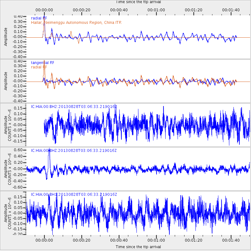
HIA Hailar, Neimenggu Autonomous Region, China - Earthquake Result Viewer
*The percent match for this event was below the threshold and hence no stack was calculated.
| Earthquake location: |
Kermadec Islands Region |
| Earthquake latitude/longitude: |
-27.8/179.6 |
| Earthquake time(UTC): |
2013/08/28 (240) 02:54:41 GMT |
| Earthquake Depth: |
478 km |
| Earthquake Magnitude: |
6.2 MWW, 6.2 MWW, 6.2 MWB, 6.2 MWC, 6.3 MWC |
| Earthquake Catalog/Contributor: |
NEIC PDE/NEIC COMCAT |
|
| Network: |
IC New China Digital Seismograph Network |
| Station: |
HIA Hailar, Neimenggu Autonomous Region, China |
| Lat/Lon: |
49.27 N/119.74 E |
| Elevation: |
620 m |
|
| Distance: |
93.4 deg |
| Az: |
325.415 deg |
| Baz: |
129.842 deg |
| Ray Param: |
$rayparam |
*The percent match for this event was below the threshold and hence was not used in the summary stack. |
|
| Radial Match: |
69.16643 % |
| Radial Bump: |
393 |
| Transverse Match: |
41.582817 % |
| Transverse Bump: |
400 |
| SOD ConfigId: |
626651 |
| Insert Time: |
2014-04-18 03:59:06.979 +0000 |
| GWidth: |
2.5 |
| Max Bumps: |
400 |
| Tol: |
0.001 |
|
Signal To Noise
| Channel | StoN | STA | LTA |
| IC:HIA:00:BHZ:20130828T03:06:33.219016Z | 4.9742026 | 2.6574781E-7 | 5.342521E-8 |
| IC:HIA:00:BH1:20130828T03:06:33.219016Z | 1.454844 | 7.6501E-8 | 5.2583644E-8 |
| IC:HIA:00:BH2:20130828T03:06:33.219016Z | 1.2493361 | 7.220357E-8 | 5.7793553E-8 |
| Arrivals |
| Ps | |
| PpPs | |
| PsPs/PpSs | |


