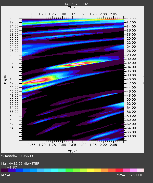
059A Moore Haven, FL, USA - Earthquake Result Viewer

Earthquake location: Andreanof Islands, Aleutian Is.
Earthquake latitude/longitude: 51.6/-174.8
Earthquake time(UTC): 2013/09/04 (247) 02:32:30 GMT
Earthquake Depth: 20 km
Earthquake Magnitude: 6.5 MWW, 5.9 ML, 6.3 MWB, 6.5 MI, 6.5 MWC, 6.5 MWW
Earthquake Catalog/Contributor: NEIC PDE/NEIC COMCAT
Network: TA USArray Transportable Network (new EarthScope stations)
Station: 059A Moore Haven, FL, USA
Lat/Lon: 26.97 N/81.14 W
Elevation: 11 m
Distance: 71.5 deg
Az: 69.917 deg
Baz: 318.931 deg
Ray Param: 0.054260835
Estimated Moho Depth: 32.25 km
Estimated Crust Vp/Vs: 1.87
Assumed Crust Vp: 6.347 km/s
Estimated Crust Vs: 3.394 km/s
Estimated Crust Poisson's Ratio: 0.30
Radial Match: 90.05639 %
Radial Bump: 400
Transverse Match: 81.91925 %
Transverse Bump: 400
SOD ConfigId: 626651
Insert Time: 2014-04-18 10:09:04.457 +0000
GWidth: 2.5
Max Bumps: 400
Tol: 0.001

Signal To Noise

ChannelStoNSTALTA
TA:059A: :BHZ:20130904T02:43:18.699976Z5.4158359.615035E-71.7753561E-7
TA:059A: :BHN:20130904T02:43:18.699976Z1.33587363.2696136E-72.4475472E-7
TA:059A: :BHE:20130904T02:43:18.699976Z1.29161023.6826833E-72.851234E-7
Arrivals
Ps4.6 SECOND
PpPs14 SECOND
PsPs/PpSs19 SECOND