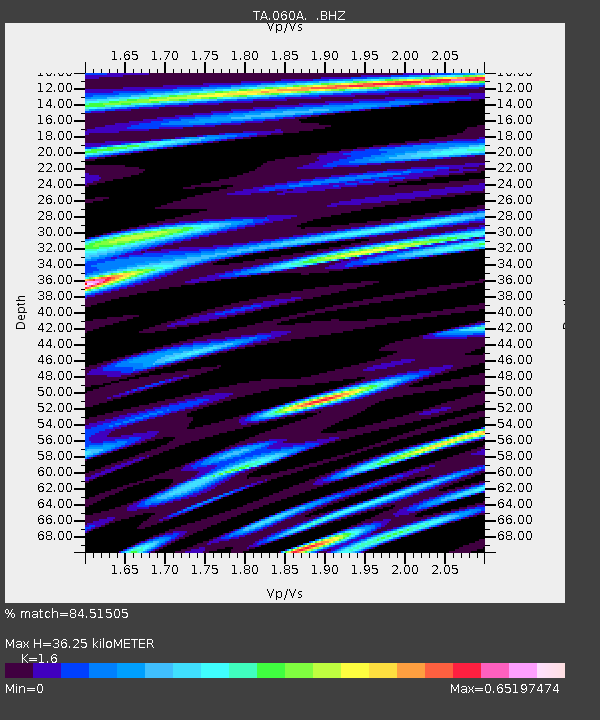
060A Indiantown, FL, USA - Earthquake Result Viewer

Earthquake location: Andreanof Islands, Aleutian Is.
Earthquake latitude/longitude: 51.6/-174.8
Earthquake time(UTC): 2013/09/04 (247) 02:32:30 GMT
Earthquake Depth: 20 km
Earthquake Magnitude: 6.5 MWW, 5.9 ML, 6.3 MWB, 6.5 MI, 6.5 MWC, 6.5 MWW
Earthquake Catalog/Contributor: NEIC PDE/NEIC COMCAT
Network: TA USArray Transportable Network (new EarthScope stations)
Station: 060A Indiantown, FL, USA
Lat/Lon: 27.04 N/80.36 W
Elevation: 9.0 m
Distance: 71.9 deg
Az: 69.315 deg
Baz: 319.096 deg
Ray Param: 0.053989653
Estimated Moho Depth: 36.25 km
Estimated Crust Vp/Vs: 1.60
Assumed Crust Vp: 6.347 km/s
Estimated Crust Vs: 3.967 km/s
Estimated Crust Poisson's Ratio: 0.18
Radial Match: 84.51505 %
Radial Bump: 400
Transverse Match: 67.46308 %
Transverse Bump: 400
SOD ConfigId: 626651
Insert Time: 2014-04-18 10:09:09.184 +0000
GWidth: 2.5
Max Bumps: 400
Tol: 0.001

Signal To Noise

ChannelStoNSTALTA
TA:060A: :BHZ:20130904T02:43:21.125024Z3.48379569.161711E-72.629807E-7
TA:060A: :BHN:20130904T02:43:21.125024Z1.46727285.947739E-74.0536017E-7
TA:060A: :BHE:20130904T02:43:21.125024Z0.732739873.3433216E-74.5627672E-7
Arrivals
Ps3.6 SECOND
PpPs14 SECOND
PsPs/PpSs18 SECOND