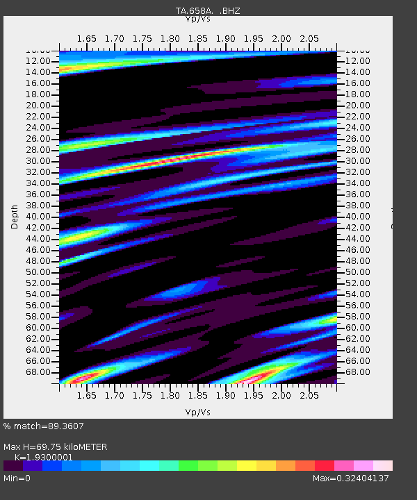
658A Bunnell, FL, USA - Earthquake Result Viewer
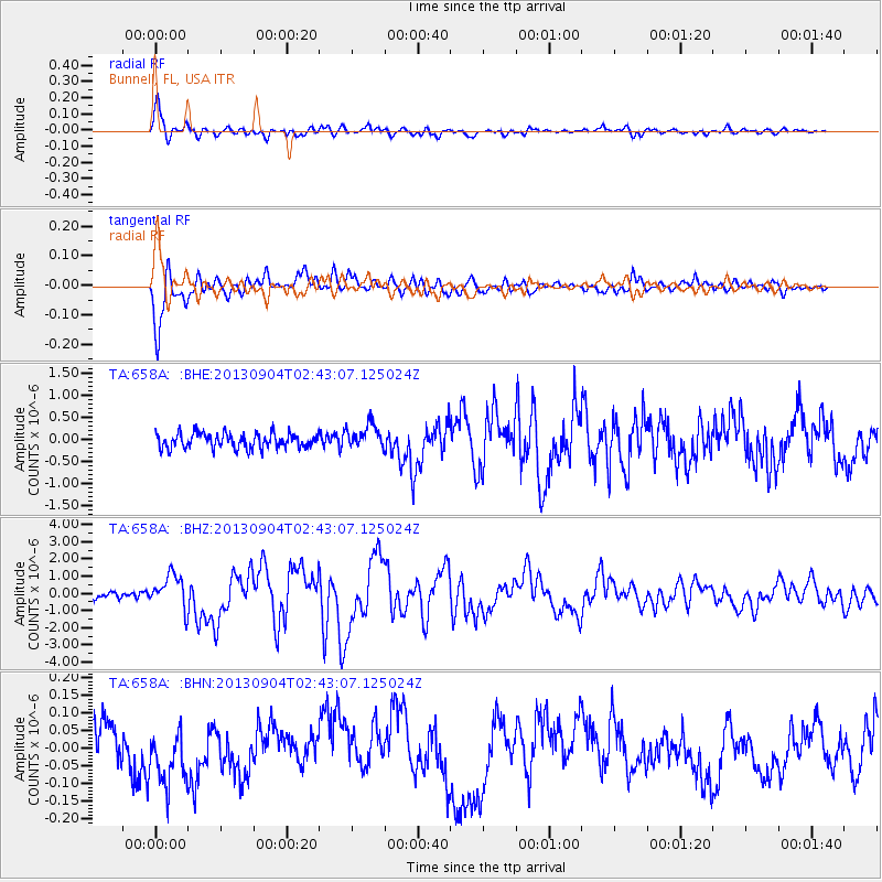
Earthquake location: Andreanof Islands, Aleutian Is.
Earthquake latitude/longitude: 51.6/-174.8
Earthquake time(UTC): 2013/09/04 (247) 02:32:30 GMT
Earthquake Depth: 20 km
Earthquake Magnitude: 6.5 MWW, 5.9 ML, 6.3 MWB, 6.5 MI, 6.5 MWC, 6.5 MWW
Earthquake Catalog/Contributor: NEIC PDE/NEIC COMCAT
Network: TA USArray Transportable Network (new EarthScope stations)
Station: 658A Bunnell, FL, USA
Lat/Lon: 29.42 N/81.26 W
Elevation: 11 m
Distance: 69.6 deg
Az: 68.283 deg
Baz: 318.334 deg
Ray Param: 0.05551477
Estimated Moho Depth: 69.75 km
Estimated Crust Vp/Vs: 1.93
Assumed Crust Vp: 6.134 km/s
Estimated Crust Vs: 3.178 km/s
Estimated Crust Poisson's Ratio: 0.32
Radial Match: 89.3607 %
Radial Bump: 400
Transverse Match: 90.55625 %
Transverse Bump: 400
SOD ConfigId: 626651
Insert Time: 2014-04-18 10:10:33.461 +0000
GWidth: 2.5
Max Bumps: 400
Tol: 0.001

Signal To Noise

ChannelStoNSTALTA
TA:658A: :BHZ:20130904T02:43:07.125024Z7.044989.84562E-71.3975371E-7
TA:658A: :BHN:20130904T02:43:07.125024Z1.44426171.0052978E-76.960635E-8
TA:658A: :BHE:20130904T02:43:07.125024Z1.640792.77721E-71.6926055E-7
Arrivals
Ps11 SECOND
PpPs32 SECOND
PsPs/PpSs43 SECOND