You are here: Home > Network List > IC - New China Digital Seismograph Network Stations List
> Station HIA Hailar, Neimenggu Autonomous Region, China > Earthquake Result Viewer
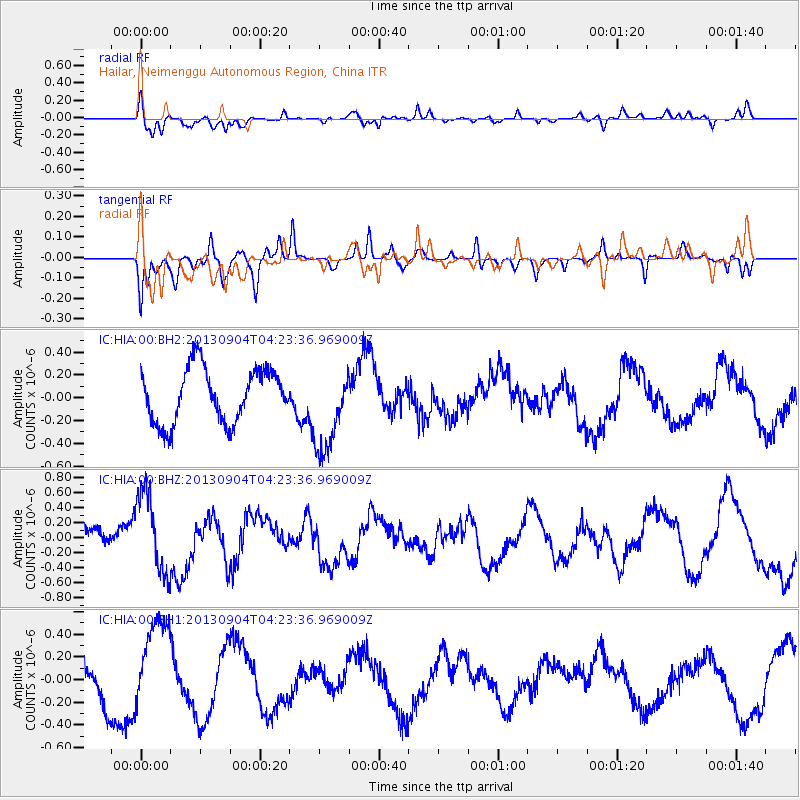
HIA Hailar, Neimenggu Autonomous Region, China - Earthquake Result Viewer
*The percent match for this event was below the threshold and hence no stack was calculated.
| Earthquake location: |
Andreanof Islands, Aleutian Is. |
| Earthquake latitude/longitude: |
51.4/-174.7 |
| Earthquake time(UTC): |
2013/09/04 (247) 04:16:30 GMT |
| Earthquake Depth: |
27 km |
| Earthquake Magnitude: |
5.9 MW, 5.2 ML, 5.4 ML, 5.8 MWW, 5.8 MWW, 5.9 MWC |
| Earthquake Catalog/Contributor: |
NEIC PDE/NEIC COMCAT |
|
| Network: |
IC New China Digital Seismograph Network |
| Station: |
HIA Hailar, Neimenggu Autonomous Region, China |
| Lat/Lon: |
49.27 N/119.74 E |
| Elevation: |
620 m |
|
| Distance: |
40.6 deg |
| Az: |
293.667 deg |
| Baz: |
61.047 deg |
| Ray Param: |
$rayparam |
*The percent match for this event was below the threshold and hence was not used in the summary stack. |
|
| Radial Match: |
56.95111 % |
| Radial Bump: |
400 |
| Transverse Match: |
49.23589 % |
| Transverse Bump: |
294 |
| SOD ConfigId: |
626651 |
| Insert Time: |
2014-04-18 10:37:55.724 +0000 |
| GWidth: |
2.5 |
| Max Bumps: |
400 |
| Tol: |
0.001 |
|
Signal To Noise
| Channel | StoN | STA | LTA |
| IC:HIA:00:BHZ:20130904T04:23:36.969009Z | 1.7648284 | 5.2890476E-7 | 2.996919E-7 |
| IC:HIA:00:BH1:20130904T04:23:36.969009Z | 2.6997294 | 4.116647E-7 | 1.5248368E-7 |
| IC:HIA:00:BH2:20130904T04:23:36.969009Z | 1.6234605 | 3.8147613E-7 | 2.3497715E-7 |
| Arrivals |
| Ps | |
| PpPs | |
| PsPs/PpSs | |


