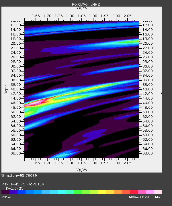
CLWO COLLINGWOOD, ON - Earthquake Result Viewer

Earthquake location: Near Coast Of Peru
Earthquake latitude/longitude: -15.8/-74.5
Earthquake time(UTC): 2013/09/25 (268) 16:42:43 GMT
Earthquake Depth: 40 km
Earthquake Magnitude: 7.1 MWW, 6.8 MI, 7.0 MWB, 7.0 MWC, 7.1 MWW, 7.1 MWC
Earthquake Catalog/Contributor: NEIC PDE/NEIC COMCAT
Network: PO Portable Observatories for Lithospheric Analysis and Research Investigating Seis
Station: CLWO COLLINGWOOD, ON
Lat/Lon: 44.45 N/80.30 W
Elevation: 485 m
Distance: 60.2 deg
Az: 355.225 deg
Baz: 173.577 deg
Ray Param: 0.06159267
Estimated Moho Depth: 45.75 km
Estimated Crust Vp/Vs: 1.64
Assumed Crust Vp: 6.53 km/s
Estimated Crust Vs: 3.976 km/s
Estimated Crust Poisson's Ratio: 0.21
Radial Match: 95.78089 %
Radial Bump: 251
Transverse Match: 86.87883 %
Transverse Bump: 400
SOD ConfigId: 626651
Insert Time: 2014-04-18 20:26:40.348 +0000
GWidth: 2.5
Max Bumps: 400
Tol: 0.001

Signal To Noise

ChannelStoNSTALTA
PO:CLWO: :HHZ:20130925T16:52:16.529985Z37.3784983.4152627E-69.1369714E-8
PO:CLWO: :HHN:20130925T16:52:16.529985Z19.2209641.6356814E-68.5098826E-8
PO:CLWO: :HHE:20130925T16:52:16.529985Z2.86496022.7175255E-79.485386E-8
Arrivals
Ps4.7 SECOND
PpPs18 SECOND
PsPs/PpSs22 SECOND