
Station PO CLWO - COLLINGWOOD, ON
Network: PO - Portable Observatories for Lithospheric Analysis and Research Investigating Seis
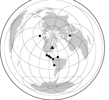
Nearby stations (2 deg radius)
| Station | Name | (Lat, Lon) | Start / End | Elevation |
| CLWO | COLLINGWOOD, ON | (44.45, -80.30) | 2009-05-20 / 2599-12-31 | 485 m |
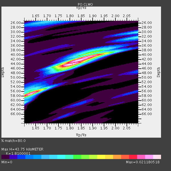
| Crust2 Type: | DE,thick Platform 1 km seds. |
| Thickness Estimate: | 44 km |
| Thickness StdDev: | 7.3 km |
| Vp/Vs Estimate: | 1.81 |
| Vp/Vs StdDev: | 0.11 |
| Vs Estimate: | 3.608 km/s |
| Poisson's Ratio: | 0.28 |
| Peak Value: | 0.02 |
| Assumed Vp: | 6.53 km/s |
| Ps Weight: | 0.33333334 |
| PpPs Weight: | 0.33333334 |
| PsPs Weight: | 0.33333328 |
| Residual Complexity: | 0.659 |
| Nearby stations H: | +- |
| (2.0 deg) Vp/Vs: | +- |
4 with match > 90% ( 16.0 %) and 8 with match > 80% ( 32.0 %) out of 25.
Download stack as xyz text file.
Azimuth Distribution of Events:
Prior Results for this Station
| Study | Thickness | Vp/Vs | Vp | Vs | Poissons Ratio | Extra |
| EARS | 44 km | 1.81 | 6.53 km/s | 3.608 km/s | 0.28 | |
| Crust2.0 | 46 km | 1.77 | 6.53 km/s | 3.68 km/s | 0.27 | DE,thick Platform 1 km seds. |
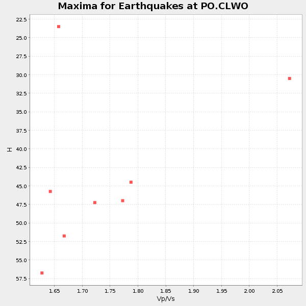
| Global Maxima | 44 km | 1.81 | 6.53 km/s | 3.608 km/s | 0.28 | amp=0.021180518 |
| Local Maxima 1 | 57 km | 1.63 | 6.53 km/s | 4.006 km/s | 0.20 | amp=0.019520374 |
| Local Maxima 2 | 40 km | 1.90 | 6.53 km/s | 3.433 km/s | 0.31 | amp=0.017191626 |
| Local Maxima 3 | 30 km | 2.10 | 6.53 km/s | 3.113 km/s | 0.35 | amp=0.0077518504 |
| Local Maxima 4 | 25 km | 1.71 | 6.53 km/s | 3.819 km/s | 0.24 | amp=0.0068197134 |
| Predicted Arrivals for vertical incidence (zero ray parameter) | |
| Ps | 5.43 SECOND |
| PpPs | 18.83 SECOND |
| PsPs/PpSs | 24.25 SECOND |
Events Processed for this Station
Download zip of receiver functions as SAC
Plot maxima for each earthquake.
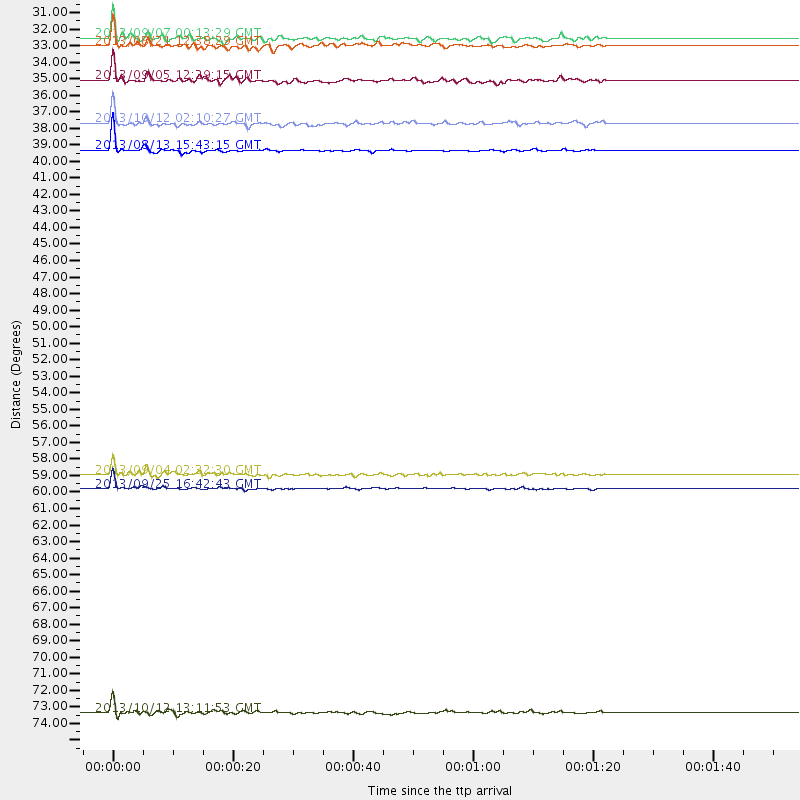
Events Used in the Stack
(8 events)| Radial Match | Distance | Baz | FERegion | Time | Lat/Lon | Depth | Magnitude |
| 96.03991 | 38.6 deg | 176.645 deg | South Of Panama | 2013/08/13 15:43:15 GMT | (5.8, -78.2) | 12 km | 6.7 MWW, 6.6 MWB, 6.7 MWW, 6.7 MWC, 6.7 MI |
| 95.78089 | 60.2 deg | 173.577 deg | Near Coast Of Peru | 2013/09/25 16:42:43 GMT | (-15.8, -74.5) | 40 km | 7.1 MWW, 6.8 MI, 7.0 MWB, 7.0 MWC, 7.1 MWW, 7.1 MWC |
| 92.64175 | 74.5 deg | 55.375 deg | Crete, Greece | 2013/10/12 13:11:53 GMT | (35.5, 23.3) | 40 km | 6.6 MWW, 6.5 MWB, 6.6 MWW, 6.7 MWC |
| 92.405655 | 59.3 deg | 313.635 deg | Andreanof Islands, Aleutian Is. | 2013/09/04 02:32:30 GMT | (51.6, -174.8) | 20 km | 6.5 MWW, 5.9 ML, 6.3 MWB, 6.5 MI, 6.5 MWC, 6.5 MWW |
| 89.696556 | 31.9 deg | 216.571 deg | Near Coast Of Guerrero, Mexico | 2013/08/21 12:38:29 GMT | (16.9, -99.5) | 21 km | 6.2 MWW, 6.2 MWW, 6.2 MWB, 6.2 MWC |
| 87.69636 | 36.8 deg | 149.619 deg | Near Coast Of Venezuela | 2013/10/12 02:10:27 GMT | (10.9, -62.3) | 63 km | 6.0 MWW, 6.0 MWW, 6.0 MWB, 6.0 MWC, 6.0 MI |
| 86.42429 | 31.4 deg | 202.37 deg | Near Coast Of Chiapas, Mexico | 2013/09/07 00:13:29 GMT | (14.6, -92.1) | 66 km | 6.4 MWW, 6.4 MWB, 6.4 MWC, 6.4 MWW, 6.5 MWC |
| 84.48825 | 34.1 deg | 190.206 deg | Off Coast Of Costa Rica | 2013/09/05 12:29:15 GMT | (10.6, -86.1) | 19 km | 5.9 MWW, 5.7 MWB, 5.9 MWW, 5.9 MWC |
Losers
(17 events)| Radial Match | Distance | Baz | FERegion | Time | Lat/Lon | Depth | Magnitude | Reason |
| 90.61458 | 89.2 deg | 325.623 deg | Off East Coast Of Honshu, Japan | 2013/10/25 17:10:19 GMT | (37.2, 144.7) | 35 km | 7.1 MWW, 7.1 MWW, 7.1 MWB, 7.1 MWC, 7.2 MWC, 7.5 MI | |
| 85.38333 | 59.6 deg | 313.803 deg | Andreanof Islands, Aleutian Is. | 2013/08/30 16:25:02 GMT | (51.5, -175.2) | 29 km | 7.0 MWW, 6.5 ML, 6.8 MI, 6.9 MWC, 6.9 MWB, 7.0 MWW, 7.0 MI, 7.0 MWC | |
| 76.461685 | 49.6 deg | 182.124 deg | Near Coast Of Northern Peru | 2013/08/12 09:49:32 GMT | (-5.4, -81.9) | 10 km | 6.2 MWW, 6.1 MWB, 6.2 MWW, 6.2 MWC, 6.3 MWC | |
| 76.412605 | 41.6 deg | 123.348 deg | Northern Mid-Atlantic Ridge | 2013/09/05 04:01:36 GMT | (15.2, -45.2) | 10 km | 6.0 MWW, 5.9 MWB, 6.0 MWW, 6.0 MWC | |
| 76.343864 | 72.6 deg | 329.733 deg | Sea Of Okhotsk | 2013/10/01 03:38:21 GMT | (53.2, 152.8) | 573 km | 6.7 MWW, 6.7 MWC, 6.8 MWC, 6.8 MWB | |
| 75.26931 | 59.3 deg | 313.632 deg | Andreanof Islands, Aleutian Is. | 2013/09/15 16:21:37 GMT | (51.6, -174.7) | 24 km | 6.1 MWW, 5.7 MI, 5.7 ML, 6.0 MWB, 6.1 MWC, 6.1 MWW | |
| 74.18375 | 60.3 deg | 170.499 deg | Southern Peru | 2013/07/17 02:37:43 GMT | (-15.7, -71.7) | 7.0 km | 6.0 MW, 5.6 MB, 5.8 MS, 5.8 MW | |
| 73.83951 | 33.7 deg | 299.755 deg | Queen Charlotte Islands Region | 2013/09/03 20:19:06 GMT | (51.2, -130.4) | 2.7 km | 6.1 MWW, 6.0 MWB, 6.1 MWW, 6.1 MWC, 6.2 MI, 6.2 MWC | |
| 72.743645 | 33.6 deg | 299.618 deg | Queen Charlotte Islands Region | 2013/09/04 00:23:11 GMT | (51.2, -130.2) | 9.9 km | 6.0 MW, 5.9 MI, 5.9 MWR, 6.0 MWW, 6.0 MWW, 6.0 MWC | |
| 69.32916 | 59.3 deg | 313.469 deg | Andreanof Islands, Aleutian Is. | 2013/09/05 05:43:39 GMT | (51.5, -174.6) | 20 km | 5.6 MWW, 5.4 MI, 5.5 MWB, 5.6 MWW, 5.7 MWC, 5.7 ML, 5.8 MWC | |
| 67.54674 | 31.7 deg | 201.199 deg | Guatemala | 2013/08/06 05:57:42 GMT | (14.2, -91.6) | 54 km | 5.5 MW, 5.5 MWC, 5.6 MWB | |
| 62.314587 | 59.6 deg | 313.398 deg | Andreanof Islands, Aleutian Is. | 2013/08/31 06:38:36 GMT | (51.2, -174.9) | 18 km | 6.0 MWW, 5.5 ML, 5.9 MWB, 5.9 MWC, 6.0 MWC, 6.0 MI, 6.0 MWW | |
| 61.73029 | 35.1 deg | 62.957 deg | Northern Mid-Atlantic Ridge | 2013/09/30 08:16:09 GMT | (49.5, -28.5) | 10 km | 5.5 MWC, 5.5 MWC | |
| 61.726994 | 59.3 deg | 313.659 deg | Andreanof Islands, Aleutian Is. | 2013/09/04 06:16:49 GMT | (51.6, -174.8) | 21 km | 5.7 MWW, 5.5 ML, 5.5 MI, 5.7 MWB, 5.7 MWW, 5.8 MWC | |
| 58.33165 | 72.0 deg | 53.285 deg | Greece | 2013/08/07 09:06:52 GMT | (38.7, 22.7) | 0.1 km | 5.5 MW, 5.3 MWR, 5.5 MWC | |
| 56.78174 | 59.3 deg | 313.685 deg | Andreanof Islands, Aleutian Is. | 2013/09/04 06:27:03 GMT | (51.6, -174.9) | 17 km | 6.0 MWW, 5.5 ML, 5.9 MWB, 6.0 MWW, 6.1 MWC, 6.1 MI | |
| 52.45718 | 59.3 deg | 313.468 deg | Andreanof Islands, Aleutian Is. | 2013/09/14 15:42:46 GMT | (51.4, -174.6) | 20 km | 5.9 MWW, 5.4 MI, 5.8 MWB, 5.9 MWC, 6.0 MWC |
