You are here: Home > Network List > TA - USArray Transportable Network (new EarthScope stations) Stations List
> Station 457A Yulee, FL, USA > Earthquake Result Viewer
457A Yulee, FL, USA - Earthquake Result Viewer
| Earthquake location: |
Near Coast Of Peru |
| Earthquake latitude/longitude: |
-15.8/-74.5 |
| Earthquake time(UTC): |
2013/09/25 (268) 16:42:43 GMT |
| Earthquake Depth: |
40 km |
| Earthquake Magnitude: |
7.1 MWW, 6.8 MI, 7.0 MWB, 7.0 MWC, 7.1 MWW, 7.1 MWC |
| Earthquake Catalog/Contributor: |
NEIC PDE/NEIC COMCAT |
|
| Network: |
TA USArray Transportable Network (new EarthScope stations) |
| Station: |
457A Yulee, FL, USA |
| Lat/Lon: |
30.62 N/81.56 W |
| Elevation: |
16 m |
|
| Distance: |
46.7 deg |
| Az: |
351.644 deg |
| Baz: |
170.662 deg |
| Ray Param: |
0.07039723 |
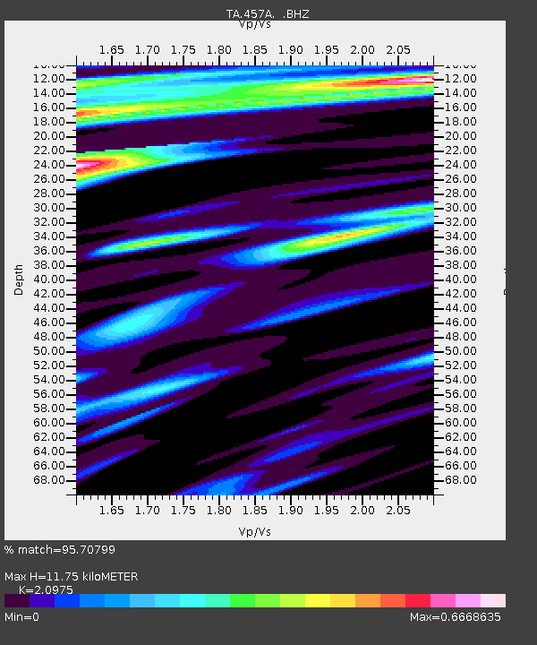
| Estimated Moho Depth: |
11.75 km |
| Estimated Crust Vp/Vs: |
2.10 |
| Assumed Crust Vp: |
5.989 km/s |
| Estimated Crust Vs: |
2.855 km/s |
| Estimated Crust Poisson's Ratio: |
0.35 |
|
| Radial Match: |
95.70799 % |
| Radial Bump: |
400 |
| Transverse Match: |
72.70277 % |
| Transverse Bump: |
400 |
| SOD ConfigId: |
626651 |
| Insert Time: |
2014-04-18 20:31:40.835 +0000 |
| GWidth: |
2.5 |
| Max Bumps: |
400 |
| Tol: |
0.001 |
|
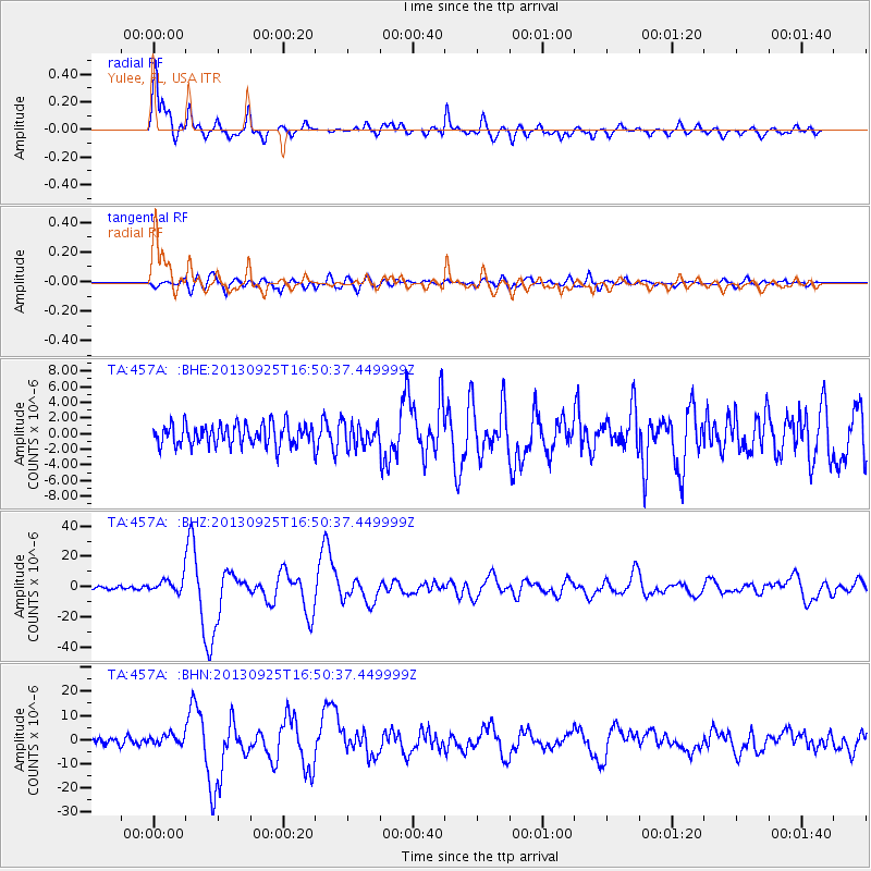
Signal To Noise
| Channel | StoN | STA | LTA |
| TA:457A: :BHZ:20130925T16:50:37.449999Z | 5.221587 | 4.703254E-6 | 9.007326E-7 |
| TA:457A: :BHN:20130925T16:50:37.449999Z | 1.7781534 | 2.0371185E-6 | 1.145637E-6 |
| TA:457A: :BHE:20130925T16:50:37.449999Z | 1.046947 | 1.4270446E-6 | 1.3630533E-6 |
| Arrivals |
| Ps | 2.3 SECOND |
| PpPs | 5.8 SECOND |
| PsPs/PpSs | 8.1 SECOND |


