You are here: Home > Network List > TA - USArray Transportable Network (new EarthScope stations) Stations List
> Station S61A Accomac, VA, USA > Earthquake Result Viewer
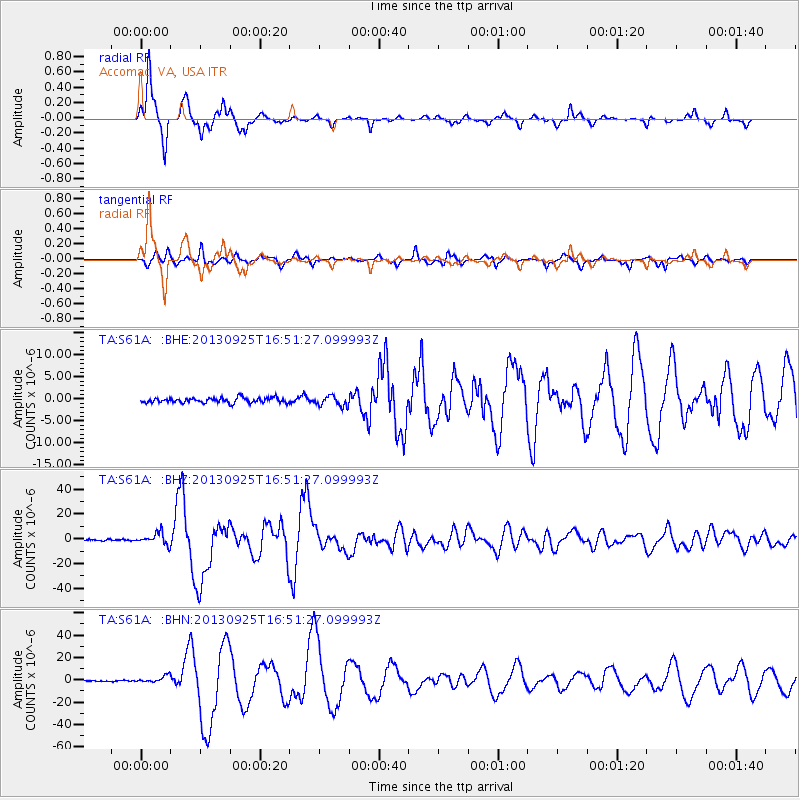
S61A Accomac, VA, USA - Earthquake Result Viewer
*The percent match for this event was below the threshold and hence no stack was calculated.
| Earthquake location: |
Near Coast Of Peru |
| Earthquake latitude/longitude: |
-15.8/-74.5 |
| Earthquake time(UTC): |
2013/09/25 (268) 16:42:43 GMT |
| Earthquake Depth: |
40 km |
| Earthquake Magnitude: |
7.1 MWW, 6.8 MI, 7.0 MWB, 7.0 MWC, 7.1 MWW, 7.1 MWC |
| Earthquake Catalog/Contributor: |
NEIC PDE/NEIC COMCAT |
|
| Network: |
TA USArray Transportable Network (new EarthScope stations) |
| Station: |
S61A Accomac, VA, USA |
| Lat/Lon: |
37.68 N/75.67 W |
| Elevation: |
58 m |
|
| Distance: |
53.2 deg |
| Az: |
358.85 deg |
| Baz: |
178.605 deg |
| Ray Param: |
$rayparam |
*The percent match for this event was below the threshold and hence was not used in the summary stack. |
|
| Radial Match: |
96.172676 % |
| Radial Bump: |
257 |
| Transverse Match: |
90.86573 % |
| Transverse Bump: |
307 |
| SOD ConfigId: |
626651 |
| Insert Time: |
2014-04-18 20:46:59.555 +0000 |
| GWidth: |
2.5 |
| Max Bumps: |
400 |
| Tol: |
0.001 |
|
Signal To Noise
| Channel | StoN | STA | LTA |
| TA:S61A: :BHZ:20130925T16:51:27.099993Z | 8.643601 | 4.818426E-6 | 5.574559E-7 |
| TA:S61A: :BHN:20130925T16:51:27.099993Z | 3.948669 | 3.0913998E-6 | 7.828967E-7 |
| TA:S61A: :BHE:20130925T16:51:27.099993Z | 2.0363479 | 1.1461473E-6 | 5.6284455E-7 |
| Arrivals |
| Ps | |
| PpPs | |
| PsPs/PpSs | |


