
Station TA S61A - Accomac, VA, USA
Network: TA - USArray Transportable Network (new EarthScope stations)
Nearby stations (2 deg radius)
| Station | Name | (Lat, Lon) | Start / End | Elevation |
| S61A | Accomac, VA, USA | (37.68, -75.67) | 2013-05-27 / 2599-12-31 | 58 m |
| Crust2 Type: | C7,continental shelf, 6.5 km seds. |
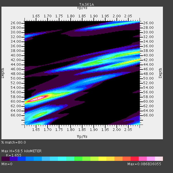
| Thickness Estimate: | 58 km |
| Thickness StdDev: | 4.5 km |
| Vp/Vs Estimate: | 1.65 |
| Vp/Vs StdDev: | 0.01 |
| Vs Estimate: | 3.515 km/s |
| Poisson's Ratio: | 0.21 |
| Peak Value: | 0.09 |
| Assumed Vp: | 5.817 km/s |
| Ps Weight: | 0.33333334 |
| PpPs Weight: | 0.33333334 |
| PsPs Weight: | 0.33333328 |
| Residual Complexity: | 0.787 |
| Nearby stations H: | +- |
| (2.0 deg) Vp/Vs: | +- |
1 with match > 90% ( 6.25 %) and 2 with match > 80% ( 12.5 %) out of 16.
Download stack as xyz text file.
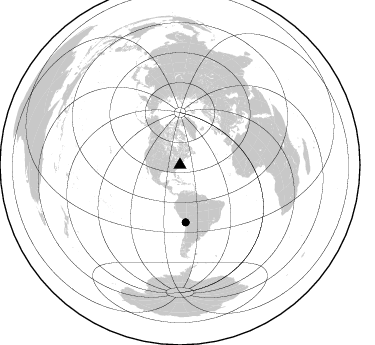
Azimuth Distribution of Events:
Prior Results for this Station
| Study | Thickness | Vp/Vs | Vp | Vs | Poissons Ratio | Extra |
| EARS | 58 km | 1.65 | 5.817 km/s | 3.515 km/s | 0.21 | |
| Crust2.0 | 32 km | 1.81 | 5.817 km/s | 3.217 km/s | 0.28 | C7,continental shelf, 6.5 km seds. |
| Global Maxima | 58 km | 1.65 | 5.817 km/s | 3.515 km/s | 0.21 | amp=0.086836055 |
| Local Maxima 1 | 38 km | 2.10 | 5.817 km/s | 2.773 km/s | 0.35 | amp=0.06542779 |
| Local Maxima 2 | 42 km | 2.10 | 5.817 km/s | 2.773 km/s | 0.35 | amp=0.057178076 |
| Local Maxima 3 | 66 km | 1.67 | 5.817 km/s | 3.489 km/s | 0.22 | amp=0.045535818 |
| Local Maxima 4 | 26 km | 1.99 | 5.817 km/s | 2.931 km/s | 0.33 | amp=0.04005512 |
| Predicted Arrivals for vertical incidence (zero ray parameter) | |
| Ps | 6.59 SECOND |
| PpPs | 26.70 SECOND |
| PsPs/PpSs | 33.29 SECOND |
Events Processed for this Station
Download zip of receiver functions as SAC
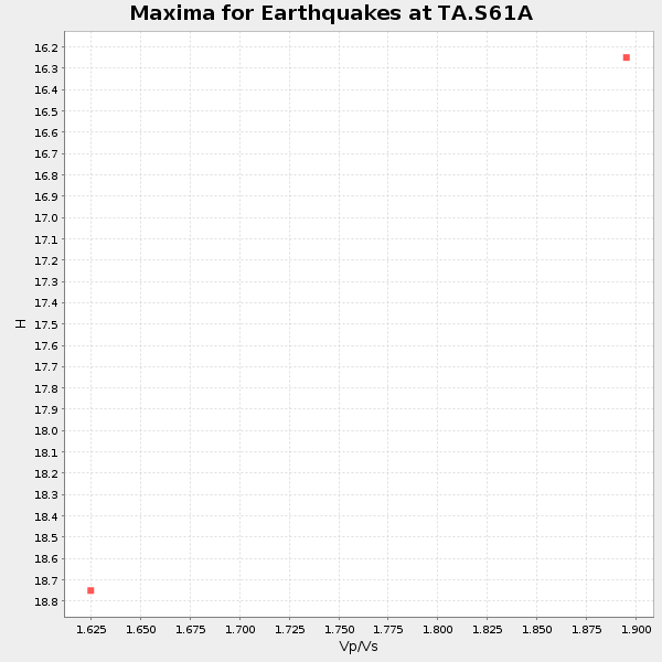
Plot maxima for each earthquake.
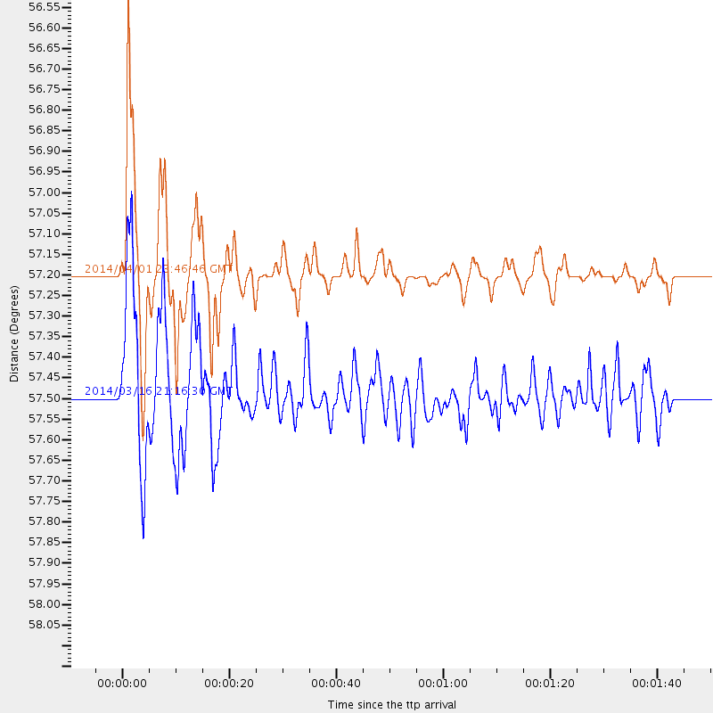
Events Used in the Stack
(2 events)| Radial Match | Distance | Baz | FERegion | Time | Lat/Lon | Depth | Magnitude |
| 97.74063 | 57.2 deg | 174.554 deg | Near Coast Of Northern Chile | 2014/04/01 23:46:46 GMT | (-19.6, -70.8) | 20 km | 8.2 MWW, 8.0 MI, 8.1 MWC |
| 84.019035 | 57.5 deg | 174.37 deg | Near Coast Of Northern Chile | 2014/03/16 21:16:30 GMT | (-19.9, -70.6) | 20 km | 6.7 MWW, 6.7 MWC, 7.0 MI |
Losers
(14 events)| Radial Match | Distance | Baz | FERegion | Time | Lat/Lon | Depth | Magnitude | Reason |
| 96.44885 | 31.8 deg | 184.77 deg | South Of Panama | 2013/08/13 15:43:15 GMT | (5.8, -78.2) | 12 km | 6.7 MWW, 6.6 MWB, 6.7 MWW, 6.7 MWC, 6.7 MI | |
| 96.172676 | 53.2 deg | 178.605 deg | Near Coast Of Peru | 2013/09/25 16:42:43 GMT | (-15.8, -74.5) | 40 km | 7.1 MWW, 6.8 MI, 7.0 MWB, 7.0 MWC, 7.1 MWW, 7.1 MWC | |
| 92.94431 | 38.0 deg | 290.579 deg | Off Coast Of Northern California | 2014/03/10 05:18:13 GMT | (40.8, -125.1) | 17 km | 6.8 MW, 6.8 MWR, 6.9 MWW, 6.9 MWB, 7.0 MI, 7.0 MWC | |
| 88.57151 | 53.2 deg | 175.266 deg | Southern Peru | 2013/07/17 02:37:43 GMT | (-15.7, -71.7) | 7.0 km | 6.0 MW, 5.6 MB, 5.8 MS, 5.8 MW | |
| 87.91343 | 66.6 deg | 317.8 deg | Andreanof Islands, Aleutian Is. | 2013/09/15 16:21:37 GMT | (51.6, -174.7) | 24 km | 6.1 MWW, 5.7 MI, 5.7 ML, 6.0 MWB, 6.1 MWC, 6.1 MWW | |
| 85.152725 | 66.9 deg | 317.947 deg | Andreanof Islands, Aleutian Is. | 2013/08/30 16:25:02 GMT | (51.5, -175.2) | 29 km | 7.0 MWW, 6.5 ML, 6.8 MI, 6.9 MWC, 6.9 MWB, 7.0 MWW, 7.0 MI, 7.0 MWC | |
| 83.77081 | 43.2 deg | 189.108 deg | Near Coast Of Northern Peru | 2013/08/12 09:49:32 GMT | (-5.4, -81.9) | 10 km | 6.2 MWW, 6.1 MWB, 6.2 MWW, 6.2 MWC, 6.3 MWC | |
| 83.292816 | 57.2 deg | 174.543 deg | Near Coast Of Northern Chile | 2014/04/02 00:06:44 GMT | (-19.6, -70.8) | 10 km | 5.7 MB | |
| 82.777824 | 40.0 deg | 123.489 deg | Northern Mid-Atlantic Ridge | 2013/06/24 22:04:13 GMT | (10.7, -42.6) | 10 km | 6.5 MW, 6.1 MB, 6.3 MS, 6.6 MW | |
| 81.33672 | 66.6 deg | 317.801 deg | Andreanof Islands, Aleutian Is. | 2013/09/04 02:32:30 GMT | (51.6, -174.8) | 20 km | 6.5 MWW, 5.9 ML, 6.3 MWB, 6.5 MI, 6.5 MWC, 6.5 MWW | |
| 73.699615 | 80.2 deg | 332.812 deg | Sea Of Okhotsk | 2013/10/01 03:38:21 GMT | (53.2, 152.8) | 573 km | 6.7 MWW, 6.7 MWC, 6.8 MWC, 6.8 MWB | |
| 73.31959 | 75.4 deg | 329.43 deg | Near East Coast Of Kamchatka | 2013/11/12 07:03:51 GMT | (54.7, 162.3) | 43 km | 6.4 MWW, 6.3 MWC, 6.4 MWW, 6.4 MWB, 6.5 MWC, 6.6 MI | |
| 68.55691 | 35.0 deg | 121.535 deg | Northern Mid-Atlantic Ridge | 2013/09/05 04:01:36 GMT | (15.2, -45.2) | 10 km | 6.0 MWW, 5.9 MWB, 6.0 MWW, 6.0 MWC | |
| 62.29665 | 97.4 deg | 329.412 deg | Off East Coast Of Honshu, Japan | 2014/01/04 05:23:00 GMT | (37.0, 143.4) | 22 km | 5.5 MWB |
