You are here: Home > Network List > TA - USArray Transportable Network (new EarthScope stations) Stations List
> Station 658A Bunnell, FL, USA > Earthquake Result Viewer
658A Bunnell, FL, USA - Earthquake Result Viewer

| Earthquake location: |
Sea Of Okhotsk |
| Earthquake latitude/longitude: |
53.2/152.8 |
| Earthquake time(UTC): |
2013/10/01 (274) 03:38:21 GMT |
| Earthquake Depth: |
573 km |
| Earthquake Magnitude: |
6.7 MWW, 6.7 MWC, 6.8 MWC, 6.8 MWB |
| Earthquake Catalog/Contributor: |
NEIC PDE/NEIC COMCAT |
|
| Network: |
TA USArray Transportable Network (new EarthScope stations) |
| Station: |
658A Bunnell, FL, USA |
| Lat/Lon: |
29.42 N/81.26 W |
| Elevation: |
11 m |
|
| Distance: |
85.3 deg |
| Az: |
45.122 deg |
| Baz: |
330.749 deg |
| Ray Param: |
0.04322709 |
| Estimated Moho Depth: |
26.25 km |
| Estimated Crust Vp/Vs: |
1.90 |
| Assumed Crust Vp: |
6.134 km/s |
| Estimated Crust Vs: |
3.22 km/s |
| Estimated Crust Poisson's Ratio: |
0.31 |
|
| Radial Match: |
89.01752 % |
| Radial Bump: |
400 |
| Transverse Match: |
66.47618 % |
| Transverse Bump: |
400 |
| SOD ConfigId: |
626651 |
| Insert Time: |
2014-04-18 23:15:15.842 +0000 |
| GWidth: |
2.5 |
| Max Bumps: |
400 |
| Tol: |
0.001 |
|
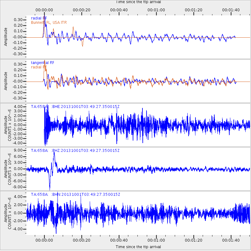
Signal To Noise
| Channel | StoN | STA | LTA |
| TA:658A: :BHZ:20131001T03:49:27.350015Z | 4.8256555 | 2.8577613E-6 | 5.9220173E-7 |
| TA:658A: :BHN:20131001T03:49:27.350015Z | 1.4285951 | 1.5885565E-6 | 1.1119712E-6 |
| TA:658A: :BHE:20131001T03:49:27.350015Z | 0.76366174 | 9.972013E-7 | 1.3058154E-6 |
| Arrivals |
| Ps | 3.9 SECOND |
| PpPs | 12 SECOND |
| PsPs/PpSs | 16 SECOND |


