You are here: Home > Network List > IC - New China Digital Seismograph Network Stations List
> Station HIA Hailar, Neimenggu Autonomous Region, China > Earthquake Result Viewer
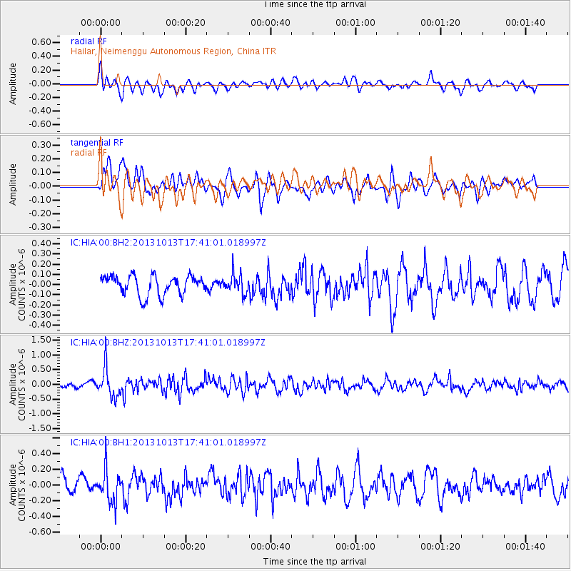
HIA Hailar, Neimenggu Autonomous Region, China - Earthquake Result Viewer
*The percent match for this event was below the threshold and hence no stack was calculated.
| Earthquake location: |
Off W Coast Of Northern Sumatra |
| Earthquake latitude/longitude: |
4.0/95.9 |
| Earthquake time(UTC): |
2013/10/13 (286) 17:32:45 GMT |
| Earthquake Depth: |
46 km |
| Earthquake Magnitude: |
5.6 MWB, 5.6 MWC |
| Earthquake Catalog/Contributor: |
NEIC PDE/NEIC COMCAT |
|
| Network: |
IC New China Digital Seismograph Network |
| Station: |
HIA Hailar, Neimenggu Autonomous Region, China |
| Lat/Lon: |
49.27 N/119.74 E |
| Elevation: |
620 m |
|
| Distance: |
49.5 deg |
| Az: |
20.406 deg |
| Baz: |
212.077 deg |
| Ray Param: |
$rayparam |
*The percent match for this event was below the threshold and hence was not used in the summary stack. |
|
| Radial Match: |
56.479565 % |
| Radial Bump: |
400 |
| Transverse Match: |
61.74115 % |
| Transverse Bump: |
400 |
| SOD ConfigId: |
626651 |
| Insert Time: |
2014-04-19 03:09:32.031 +0000 |
| GWidth: |
2.5 |
| Max Bumps: |
400 |
| Tol: |
0.001 |
|
Signal To Noise
| Channel | StoN | STA | LTA |
| IC:HIA:00:BHZ:20131013T17:41:01.018997Z | 4.083284 | 5.0010124E-7 | 1.2247526E-7 |
| IC:HIA:00:BH1:20131013T17:41:01.018997Z | 1.7753824 | 2.12632E-7 | 1.1976688E-7 |
| IC:HIA:00:BH2:20131013T17:41:01.018997Z | 1.0348643 | 9.694303E-8 | 9.3677045E-8 |
| Arrivals |
| Ps | |
| PpPs | |
| PsPs/PpSs | |


