You are here: Home > Network List > AK - Alaska Regional Network Stations List
> Station PTPK Patty Peak Repeater, AK, USA > Earthquake Result Viewer
PTPK Patty Peak Repeater, AK, USA - Earthquake Result Viewer
| Earthquake location: |
Solomon Islands |
| Earthquake latitude/longitude: |
-6.4/154.9 |
| Earthquake time(UTC): |
2013/10/16 (289) 10:30:58 GMT |
| Earthquake Depth: |
35 km |
| Earthquake Magnitude: |
6.8 MWW, 6.7 MWB, 6.8 MWW, 6.8 MWC, 7.1 MI |
| Earthquake Catalog/Contributor: |
NEIC PDE/NEIC COMCAT |
|
| Network: |
AK Alaska Regional Network |
| Station: |
PTPK Patty Peak Repeater, AK, USA |
| Lat/Lon: |
61.19 N/142.47 W |
| Elevation: |
1933 m |
|
| Distance: |
82.9 deg |
| Az: |
25.686 deg |
| Baz: |
242.767 deg |
| Ray Param: |
0.04653366 |
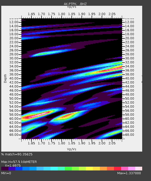
| Estimated Moho Depth: |
57.5 km |
| Estimated Crust Vp/Vs: |
1.70 |
| Assumed Crust Vp: |
6.566 km/s |
| Estimated Crust Vs: |
3.868 km/s |
| Estimated Crust Poisson's Ratio: |
0.23 |
|
| Radial Match: |
90.35625 % |
| Radial Bump: |
400 |
| Transverse Match: |
79.814156 % |
| Transverse Bump: |
400 |
| SOD ConfigId: |
626651 |
| Insert Time: |
2014-04-19 03:50:53.714 +0000 |
| GWidth: |
2.5 |
| Max Bumps: |
400 |
| Tol: |
0.001 |
|

Signal To Noise
| Channel | StoN | STA | LTA |
| AK:PTPK: :BHZ:20131016T10:42:48.407971Z | 25.869387 | 7.3469582E-6 | 2.84002E-7 |
| AK:PTPK: :BHN:20131016T10:42:48.407971Z | 7.119629 | 1.6976037E-6 | 2.3843992E-7 |
| AK:PTPK: :BHE:20131016T10:42:48.407971Z | 18.775991 | 3.2828661E-6 | 1.7484382E-7 |
| Arrivals |
| Ps | 6.3 SECOND |
| PpPs | 23 SECOND |
| PsPs/PpSs | 29 SECOND |


