You are here: Home > Network List > IC - New China Digital Seismograph Network Stations List
> Station HIA Hailar, Neimenggu Autonomous Region, China > Earthquake Result Viewer
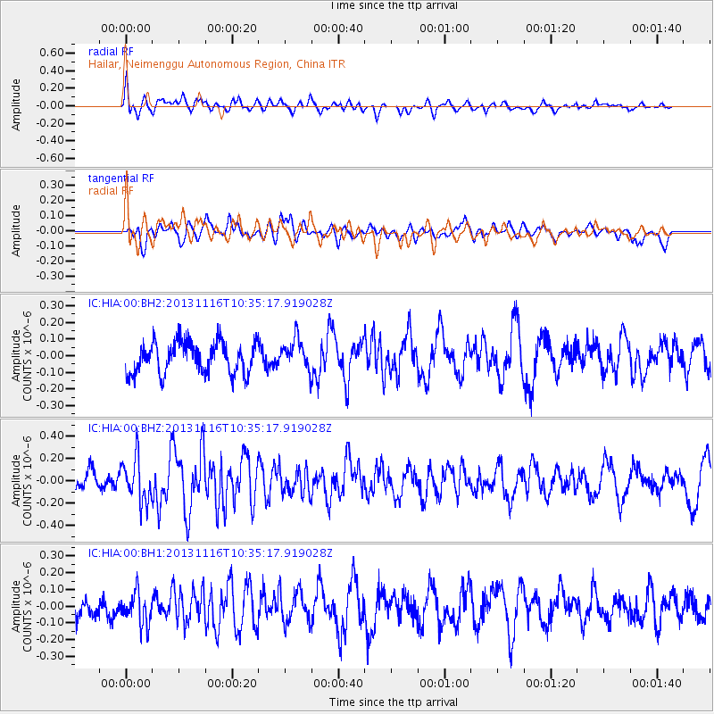
HIA Hailar, Neimenggu Autonomous Region, China - Earthquake Result Viewer
*The percent match for this event was below the threshold and hence no stack was calculated.
| Earthquake location: |
Off W Coast Of Northern Sumatra |
| Earthquake latitude/longitude: |
4.2/90.1 |
| Earthquake time(UTC): |
2013/11/16 (320) 10:26:43 GMT |
| Earthquake Depth: |
10 km |
| Earthquake Magnitude: |
5.7 MWB, 5.7 MWC |
| Earthquake Catalog/Contributor: |
NEIC PDE/NEIC COMCAT |
|
| Network: |
IC New China Digital Seismograph Network |
| Station: |
HIA Hailar, Neimenggu Autonomous Region, China |
| Lat/Lon: |
49.27 N/119.74 E |
| Elevation: |
620 m |
|
| Distance: |
51.5 deg |
| Az: |
24.483 deg |
| Baz: |
219.126 deg |
| Ray Param: |
$rayparam |
*The percent match for this event was below the threshold and hence was not used in the summary stack. |
|
| Radial Match: |
48.28591 % |
| Radial Bump: |
357 |
| Transverse Match: |
46.788 % |
| Transverse Bump: |
400 |
| SOD ConfigId: |
626651 |
| Insert Time: |
2014-04-19 15:41:16.777 +0000 |
| GWidth: |
2.5 |
| Max Bumps: |
400 |
| Tol: |
0.001 |
|
Signal To Noise
| Channel | StoN | STA | LTA |
| IC:HIA:00:BHZ:20131116T10:35:17.919028Z | 2.4505422 | 1.9717795E-7 | 8.046299E-8 |
| IC:HIA:00:BH1:20131116T10:35:17.919028Z | 2.1422467 | 9.838304E-8 | 4.592517E-8 |
| IC:HIA:00:BH2:20131116T10:35:17.919028Z | 0.9879918 | 9.261935E-8 | 9.374506E-8 |
| Arrivals |
| Ps | |
| PpPs | |
| PsPs/PpSs | |


