You are here: Home > Network List > S - Seismographs in Schools Projects Stations List
> Station AUMUL Mullumbimby High School, NSW > Earthquake Result Viewer
AUMUL Mullumbimby High School, NSW - Earthquake Result Viewer
| Earthquake location: |
Banda Sea |
| Earthquake latitude/longitude: |
-7.0/128.4 |
| Earthquake time(UTC): |
2013/12/01 (335) 01:24:13 GMT |
| Earthquake Depth: |
9.9 km |
| Earthquake Magnitude: |
6.4 MWW, 6.4 MWB, 6.5 MWC |
| Earthquake Catalog/Contributor: |
NEIC PDE/NEIC COMCAT |
|
| Network: |
S Seismographs in Schools Projects |
| Station: |
AUMUL Mullumbimby High School, NSW |
| Lat/Lon: |
28.56 S/153.04 E |
| Elevation: |
60 m |
|
| Distance: |
31.6 deg |
| Az: |
135.61 deg |
| Baz: |
307.877 deg |
| Ray Param: |
0.0789898 |
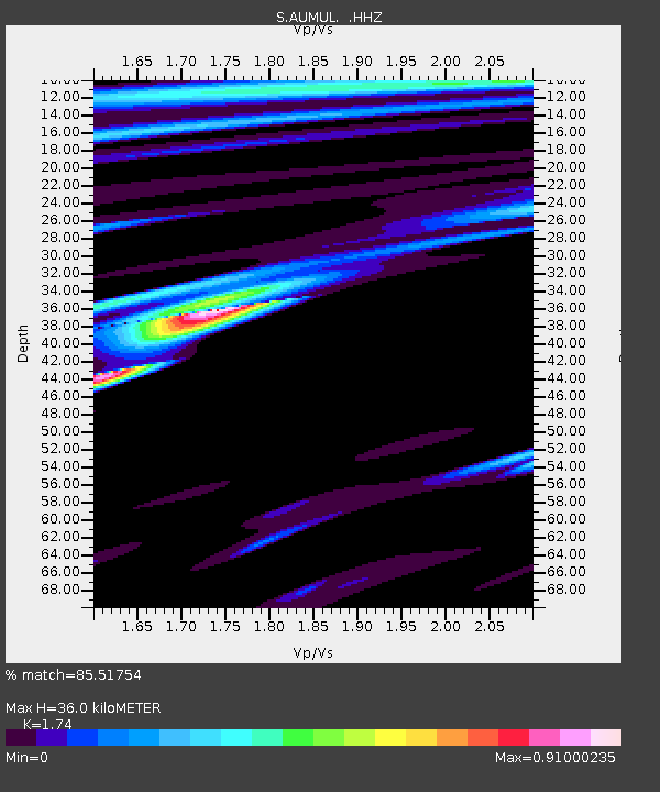
| Estimated Moho Depth: |
36.0 km |
| Estimated Crust Vp/Vs: |
1.74 |
| Assumed Crust Vp: |
6.472 km/s |
| Estimated Crust Vs: |
3.719 km/s |
| Estimated Crust Poisson's Ratio: |
0.25 |
|
| Radial Match: |
85.51754 % |
| Radial Bump: |
276 |
| Transverse Match: |
61.350525 % |
| Transverse Bump: |
400 |
| SOD ConfigId: |
626651 |
| Insert Time: |
2014-04-19 22:03:46.260 +0000 |
| GWidth: |
2.5 |
| Max Bumps: |
400 |
| Tol: |
0.001 |
|

Signal To Noise
| Channel | StoN | STA | LTA |
| S:AUMUL: :HHZ:20131201T01:30:06.049999Z | 7.11702 | 6.3986936E-6 | 8.990692E-7 |
| S:AUMUL: :HHN:20131201T01:30:06.049999Z | 1.8513463 | 2.5951747E-6 | 1.401777E-6 |
| S:AUMUL: :HHE:20131201T01:30:06.049999Z | 2.345405 | 3.952435E-6 | 1.685182E-6 |
| Arrivals |
| Ps | 4.5 SECOND |
| PpPs | 14 SECOND |
| PsPs/PpSs | 19 SECOND |


