
Station S AUMUL - Mullumbimby High School, NSW
Network: S - Seismographs in Schools Projects
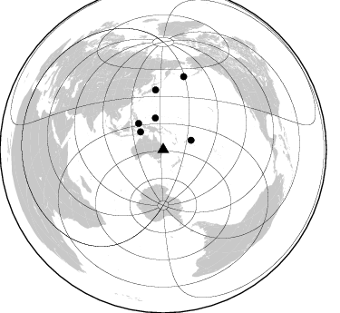
Nearby stations (2 deg radius)
| Station | Name | (Lat, Lon) | Start / End | Elevation |
| AUMUL | Mullumbimby High School, NSW | (-28.56, 153.04) | 2013-06-24 / 2599-12-31 | 60 m |
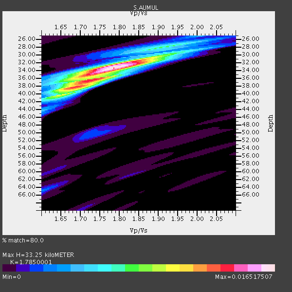
| Crust2 Type: | T6,Margin /shield transition, 1 km seds. |
| Thickness Estimate: | 33 km |
| Thickness StdDev: | 5.1 km |
| Vp/Vs Estimate: | 1.79 |
| Vp/Vs StdDev: | 0.07 |
| Vs Estimate: | 3.626 km/s |
| Poisson's Ratio: | 0.27 |
| Peak Value: | 0.02 |
| Assumed Vp: | 6.472 km/s |
| Ps Weight: | 0.33333334 |
| PpPs Weight: | 0.33333334 |
| PsPs Weight: | 0.33333328 |
| Residual Complexity: | 0.507 |
| Nearby stations H: | +- |
| (2.0 deg) Vp/Vs: | +- |
4 with match > 90% ( 16.666666 %) and 6 with match > 80% ( 25.0 %) out of 24.
Download stack as xyz text file.
Azimuth Distribution of Events:
Prior Results for this Station
| Study | Thickness | Vp/Vs | Vp | Vs | Poissons Ratio | Extra |
| EARS | 33 km | 1.79 | 6.472 km/s | 3.626 km/s | 0.27 | |
| Crust2.0 | 32 km | 1.79 | 6.472 km/s | 3.622 km/s | 0.27 | T6,Margin /shield transition, 1 km seds. |
| Global Maxima | 33 km | 1.79 | 6.472 km/s | 3.626 km/s | 0.27 | amp=0.016517507 |
| Local Maxima 1 | 36 km | 1.73 | 6.472 km/s | 3.752 km/s | 0.25 | amp=0.010585453 |
| Local Maxima 2 | 38 km | 1.68 | 6.472 km/s | 3.852 km/s | 0.23 | amp=0.0073369425 |
| Local Maxima 3 | 31 km | 1.88 | 6.472 km/s | 3.452 km/s | 0.30 | amp=0.006968632 |
| Local Maxima 4 | 28 km | 1.91 | 6.472 km/s | 3.393 km/s | 0.31 | amp=0.0035559742 |
| Predicted Arrivals for vertical incidence (zero ray parameter) | |
| Ps | 4.03 SECOND |
| PpPs | 14.31 SECOND |
| PsPs/PpSs | 18.34 SECOND |
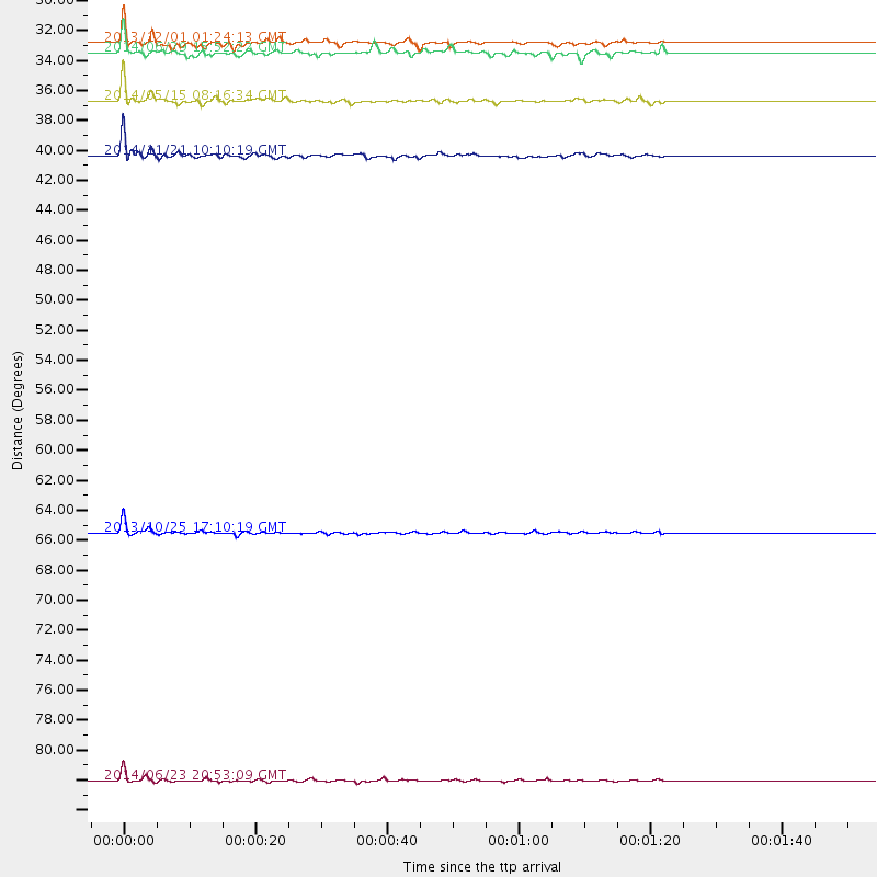
Events Processed for this Station
Download zip of receiver functions as SAC
Plot maxima for each earthquake.
Events Used in the Stack
(6 events)| Radial Match | Distance | Baz | FERegion | Time | Lat/Lon | Depth | Magnitude |
| 95.96478 | 83.1 deg | 15.752 deg | Rat Islands, Aleutian Islands | 2014/06/23 20:53:09 GMT | (51.8, 178.8) | 108 km | 7.9 MWW, 7.1 MI, 7.9 MWC |
| 95.580025 | 65.8 deg | 352.672 deg | Off East Coast Of Honshu, Japan | 2013/10/25 17:10:19 GMT | (37.2, 144.7) | 35 km | 7.1 MWW, 7.1 MWW, 7.1 MWB, 7.1 MWC, 7.2 MWC, 7.5 MI |
| 91.98047 | 39.5 deg | 316.537 deg | Northern Molucca Sea | 2014/11/21 10:10:19 GMT | (2.3, 127.1) | 38 km | 6.5 MWC, 6.8 MI, 6.9 MI |
| 90.11168 | 35.7 deg | 346.065 deg | E. Caroline Islands, Micronesia | 2014/05/15 08:16:34 GMT | (6.5, 144.9) | 10 km | 6.6 MWP, 6.6 MI |
| 85.51754 | 31.6 deg | 307.877 deg | Banda Sea | 2013/12/01 01:24:13 GMT | (-7.0, 128.4) | 9.9 km | 6.4 MWW, 6.4 MWB, 6.5 MWC |
| 84.21151 | 32.4 deg | 71.647 deg | Samoa Islands Region | 2014/06/29 15:52:22 GMT | (-14.8, -175.3) | 10 km | 6.4 MWW, 6.4 MWB, 6.5 MWC, 6.8 MI |
Losers
(18 events)| Radial Match | Distance | Baz | FERegion | Time | Lat/Lon | Depth | Magnitude | Reason |
| 75.075714 | 30.2 deg | 74.436 deg | Fiji Islands Region | 2013/11/23 07:48:32 GMT | (-17.1, -176.5) | 371 km | 6.5 MWW, 6.4 MI, 6.5 MWC, 6.5 MWB | |
| 74.85577 | 53.6 deg | 348.149 deg | Volcano Islands, Japan Region | 2014/06/29 05:56:31 GMT | (24.4, 142.6) | 43 km | 6.2 MWP | |
| 73.68706 | 80.1 deg | 121.097 deg | Southern East Pacific Rise | 2014/10/09 02:14:32 GMT | (-32.1, -110.8) | 16 km | 7.1 MWW, 6.8 MI | |
| 73.48226 | 64.7 deg | 350.202 deg | Off East Coast Of Honshu, Japan | 2013/12/23 06:57:29 GMT | (35.7, 142.1) | 8.0 km | 5.6 MWB, 5.6 MWC | |
| 73.04485 | 42.1 deg | 343.329 deg | South Of Mariana Islands | 2013/10/06 16:38:08 GMT | (12.3, 141.7) | 104 km | 6.0 MWW, 6.0 MWB, 6.0 MWW, 6.1 MWC | |
| 72.78572 | 32.7 deg | 81.031 deg | Tonga Islands Region | 2013/11/02 18:53:46 GMT | (-19.2, -172.6) | 10 km | 6.2 MWW, 6.2 MWB, 6.2 MWW, 6.3 MWC, 6.5 MI | |
| 67.50654 | 75.1 deg | 309.587 deg | Myanmar-China Border Region | 2014/05/23 20:49:24 GMT | (25.0, 97.9) | 25 km | 5.6 MB | |
| 64.377655 | 39.1 deg | 333.89 deg | W. Caroline Islands, Micronesia | 2014/07/28 03:36:45 GMT | (7.5, 136.8) | 4.2 km | 5.6 MWW, 5.5 MWC, 5.6 MWB | |
| 64.28252 | 42.2 deg | 349.97 deg | South Of Mariana Islands | 2014/01/23 04:59:49 GMT | (13.4, 146.1) | 7.0 km | 5.8 MWW, 5.8 MWB, 5.8 MWC | |
| 62.44694 | 80.7 deg | 3.071 deg | Kamchatka Peninsula, Russia | 2014/10/02 12:57:06 GMT | (52.4, 158.0) | 150 km | 5.7 MB | |
| 59.623028 | 84.4 deg | 7.896 deg | Komandorskiye Ostrova Region | 2014/07/03 02:56:41 GMT | (55.3, 166.9) | 23 km | 5.8 MWP | |
| 59.044262 | 80.0 deg | 120.676 deg | Easter Island Region | 2014/11/01 10:59:55 GMT | (-31.8, -111.2) | 10 km | 6.0 MWP | |
| 55.82245 | 38.9 deg | 316.634 deg | Halmahera, Indonesia | 2014/03/26 20:47:51 GMT | (1.8, 127.5) | 151 km | 5.5 MB, 5.4 MWW, 5.5 MWC | |
| 55.22265 | 49.4 deg | 352.294 deg | Mariana Islands Region | 2013/12/17 23:38:06 GMT | (20.8, 146.8) | 9.0 km | 6.2 MWW, 6.1 MWB, 6.2 MWC, 6.4 MWC | |
| 54.039536 | 60.0 deg | 139.493 deg | Pacific-Antarctic Ridge | 2014/06/03 04:39:57 GMT | (-55.0, -129.6) | 13 km | 5.6 MWC, 5.6 MWC | |
| 52.34799 | 90.0 deg | 170.029 deg | Scotia Sea | 2014/02/22 22:39:32 GMT | (-60.2, -47.3) | 10 km | 5.5 MWB, 5.4 MWC | |
| 51.195824 | 87.3 deg | 20.084 deg | Fox Islands, Aleutian Islands | 2014/02/26 21:13:40 GMT | (53.6, -171.8) | 265 km | 6.1 MWW, 5.9 MI, 5.9 ML, 6.1 MWC, 6.1 MWB, 6.2 MWC | |
| 38.77897 | 84.6 deg | 19.596 deg | Andreanof Islands, Aleutian Is. | 2013/09/04 04:16:30 GMT | (51.4, -174.7) | 27 km | 5.9 MW, 5.2 ML, 5.4 ML, 5.8 MWW, 5.8 MWW, 5.9 MWC |

