You are here: Home > Network List > IC - New China Digital Seismograph Network Stations List
> Station HIA Hailar, Neimenggu Autonomous Region, China > Earthquake Result Viewer
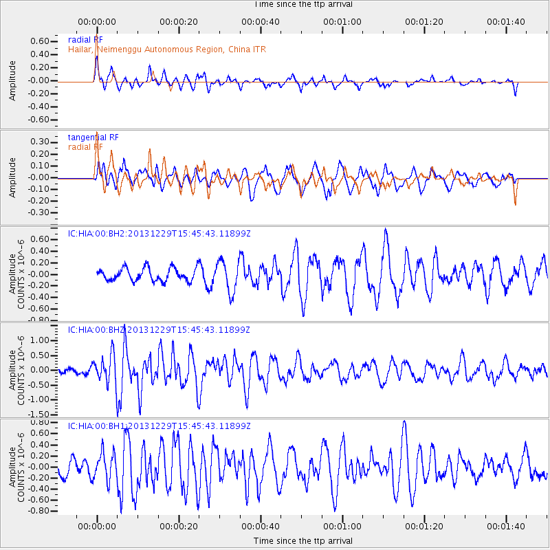
HIA Hailar, Neimenggu Autonomous Region, China - Earthquake Result Viewer
*The percent match for this event was below the threshold and hence no stack was calculated.
| Earthquake location: |
Northern Molucca Sea |
| Earthquake latitude/longitude: |
1.3/126.2 |
| Earthquake time(UTC): |
2013/12/29 (363) 15:37:38 GMT |
| Earthquake Depth: |
43 km |
| Earthquake Magnitude: |
5.7 MWW, 5.7 MWB, 5.8 MWC |
| Earthquake Catalog/Contributor: |
NEIC PDE/NEIC COMCAT |
|
| Network: |
IC New China Digital Seismograph Network |
| Station: |
HIA Hailar, Neimenggu Autonomous Region, China |
| Lat/Lon: |
49.27 N/119.74 E |
| Elevation: |
620 m |
|
| Distance: |
48.1 deg |
| Az: |
354.28 deg |
| Baz: |
171.251 deg |
| Ray Param: |
$rayparam |
*The percent match for this event was below the threshold and hence was not used in the summary stack. |
|
| Radial Match: |
63.5819 % |
| Radial Bump: |
318 |
| Transverse Match: |
43.51368 % |
| Transverse Bump: |
400 |
| SOD ConfigId: |
626651 |
| Insert Time: |
2014-04-20 05:43:45.505 +0000 |
| GWidth: |
2.5 |
| Max Bumps: |
400 |
| Tol: |
0.001 |
|
Signal To Noise
| Channel | StoN | STA | LTA |
| IC:HIA:00:BHZ:20131229T15:45:43.11899Z | 3.7307944 | 4.749862E-7 | 1.2731503E-7 |
| IC:HIA:00:BH1:20131229T15:45:43.11899Z | 1.2353343 | 2.440673E-7 | 1.9757186E-7 |
| IC:HIA:00:BH2:20131229T15:45:43.11899Z | 2.4848707 | 2.7473416E-7 | 1.1056276E-7 |
| Arrivals |
| Ps | |
| PpPs | |
| PsPs/PpSs | |


