You are here: Home > Network List > TA - USArray Transportable Network (new EarthScope stations) Stations List
> Station M66A Nantucket, MA, USA > Earthquake Result Viewer
M66A Nantucket, MA, USA - Earthquake Result Viewer
| Earthquake location: |
Near Coast Of Nicaragua |
| Earthquake latitude/longitude: |
12.6/-87.7 |
| Earthquake time(UTC): |
2014/03/02 (061) 09:37:54 GMT |
| Earthquake Depth: |
60 km |
| Earthquake Magnitude: |
6.2 MWW, 6.2 MWB, 6.2 MWC, 6.3 MWC |
| Earthquake Catalog/Contributor: |
NEIC PDE/NEIC COMCAT |
|
| Network: |
TA USArray Transportable Network (new EarthScope stations) |
| Station: |
M66A Nantucket, MA, USA |
| Lat/Lon: |
41.26 N/70.14 W |
| Elevation: |
9.0 m |
|
| Distance: |
32.5 deg |
| Az: |
25.062 deg |
| Baz: |
213.27 deg |
| Ray Param: |
0.07850825 |
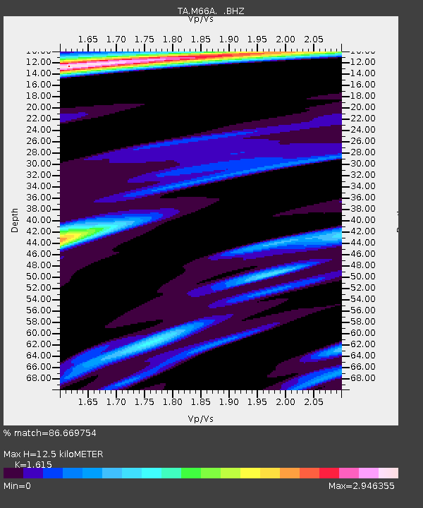
| Estimated Moho Depth: |
12.5 km |
| Estimated Crust Vp/Vs: |
1.62 |
| Assumed Crust Vp: |
6.472 km/s |
| Estimated Crust Vs: |
4.007 km/s |
| Estimated Crust Poisson's Ratio: |
0.19 |
|
| Radial Match: |
86.669754 % |
| Radial Bump: |
400 |
| Transverse Match: |
55.16573 % |
| Transverse Bump: |
400 |
| SOD ConfigId: |
626651 |
| Insert Time: |
2014-04-20 23:32:03.485 +0000 |
| GWidth: |
2.5 |
| Max Bumps: |
400 |
| Tol: |
0.001 |
|
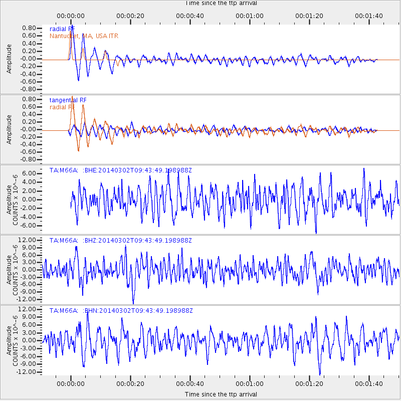
Signal To Noise
| Channel | StoN | STA | LTA |
| TA:M66A: :BHZ:20140302T09:43:49.198988Z | 2.2243435 | 5.106619E-6 | 2.295787E-6 |
| TA:M66A: :BHN:20140302T09:43:49.198988Z | 2.525038 | 4.629093E-6 | 1.8332765E-6 |
| TA:M66A: :BHE:20140302T09:43:49.198988Z | 1.5216229 | 3.3346603E-6 | 2.1915157E-6 |
| Arrivals |
| Ps | 1.3 SECOND |
| PpPs | 4.6 SECOND |
| PsPs/PpSs | 5.9 SECOND |


