
Station TA M66A - Nantucket, MA, USA
Network: TA - USArray Transportable Network (new EarthScope stations)
Nearby stations (2 deg radius)
| Station | Name | (Lat, Lon) | Start / End | Elevation |
| M66A | Nantucket, MA, USA | (41.26, -70.14) | 2013-09-28 / 2599-12-31 | 9.0 m |
| Crust2 Type: | T6,Margin /shield transition, 1 km seds. |
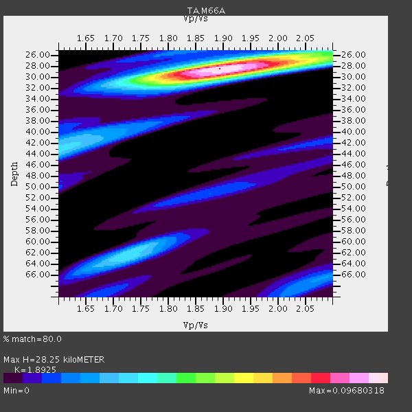
| Thickness Estimate: | 28 km |
| Thickness StdDev: | 3.2 km |
| Vp/Vs Estimate: | 1.89 |
| Vp/Vs StdDev: | 0.08 |
| Vs Estimate: | 3.42 km/s |
| Poisson's Ratio: | 0.31 |
| Peak Value: | 0.10 |
| Assumed Vp: | 6.472 km/s |
| Ps Weight: | 0.33333334 |
| PpPs Weight: | 0.33333334 |
| PsPs Weight: | 0.33333328 |
| Residual Complexity: | 0.513 |
| Nearby stations H: | +- |
| (2.0 deg) Vp/Vs: | +- |
5 with match > 90% ( 33.333332 %) and 8 with match > 80% ( 53.333332 %) out of 15.
Download stack as xyz text file.
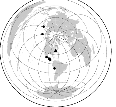
Azimuth Distribution of Events:
Prior Results for this Station
| Study | Thickness | Vp/Vs | Vp | Vs | Poissons Ratio | Extra |
| EARS | 28 km | 1.89 | 6.472 km/s | 3.42 km/s | 0.31 | |
| Crust2.0 | 32 km | 1.79 | 6.472 km/s | 3.622 km/s | 0.27 | T6,Margin /shield transition, 1 km seds. |
| Global Maxima | 28 km | 1.89 | 6.472 km/s | 3.42 km/s | 0.31 | amp=0.09680318 |
| Local Maxima 1 | 30 km | 1.88 | 6.472 km/s | 3.433 km/s | 0.30 | amp=0.05077249 |
| Local Maxima 2 | 62 km | 1.73 | 6.472 km/s | 3.736 km/s | 0.25 | amp=0.03333762 |
| Local Maxima 3 | 42 km | 1.62 | 6.472 km/s | 4.001 km/s | 0.19 | amp=0.029735463 |
| Local Maxima 4 | 26 km | 1.98 | 6.472 km/s | 3.265 km/s | 0.33 | amp=0.025058668 |
| Predicted Arrivals for vertical incidence (zero ray parameter) | |
| Ps | 3.90 SECOND |
| PpPs | 12.63 SECOND |
| PsPs/PpSs | 16.52 SECOND |
Events Processed for this Station
Download zip of receiver functions as SAC
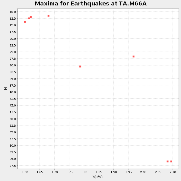
Plot maxima for each earthquake.
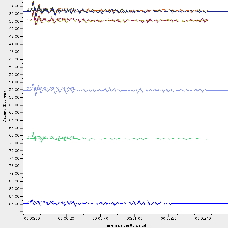
Events Used in the Stack
(8 events)| Radial Match | Distance | Baz | FERegion | Time | Lat/Lon | Depth | Magnitude |
| 95.24303 | 69.7 deg | 321.86 deg | Rat Islands, Aleutian Islands | 2014/06/23 20:53:09 GMT | (51.8, 178.8) | 108 km | 7.9 MWW, 7.1 MI, 7.9 MWC |
| 95.12273 | 32.6 deg | 213.878 deg | Off Coast Of Central America | 2014/10/14 03:51:35 GMT | (12.6, -88.0) | 40 km | 7.3 MWW, 7.4 MI |
| 92.65819 | 35.4 deg | 236.868 deg | Guerrero, Mexico | 2014/05/08 17:00:17 GMT | (17.4, -100.7) | 24 km | 6.4 MWW, 6.8 MI |
| 90.87692 | 32.7 deg | 222.69 deg | Near Coast Of Chiapas, Mexico | 2014/07/07 11:23:55 GMT | (14.7, -92.4) | 60 km | 6.9 MWW, 6.9 MWC, 7.1 MI |
| 90.624306 | 55.7 deg | 184.038 deg | Central Peru | 2014/08/24 23:21:45 GMT | (-14.6, -73.6) | 101 km | 6.9 MWW, 6.8 MI, 6.9 MWB |
| 88.10372 | 35.4 deg | 237.256 deg | Guerrero, Mexico | 2014/04/18 14:27:26 GMT | (17.6, -100.8) | 24 km | 7.2 MWW, 7.0 MWB, 7.3 MWC, 7.5 MI |
| 86.669754 | 32.5 deg | 213.27 deg | Near Coast Of Nicaragua | 2014/03/02 09:37:54 GMT | (12.6, -87.7) | 60 km | 6.2 MWW, 6.2 MWB, 6.2 MWC, 6.3 MWC |
| 81.51389 | 88.5 deg | 333.559 deg | Kuril Islands | 2015/07/07 05:10:27 GMT | (44.0, 147.9) | 38 km | 6.3 MO |
Losers
(7 events)| Radial Match | Distance | Baz | FERegion | Time | Lat/Lon | Depth | Magnitude | Reason |
| 96.23033 | 61.5 deg | 180.387 deg | Near Coast Of Northern Chile | 2014/04/03 02:43:14 GMT | (-20.5, -70.5) | 31 km | 7.7 MWW, 7.4 MI, 7.7 MWC | |
| 77.01791 | 61.7 deg | 180.439 deg | Near Coast Of Northern Chile | 2014/04/03 05:26:16 GMT | (-20.8, -70.5) | 24 km | 6.2 MWP, 6.2 MWR, 6.3 MWW, 6.5 MWC | |
| 71.78368 | 34.4 deg | 185.062 deg | Northern Colombia | 2015/03/10 20:55:43 GMT | (6.8, -73.0) | 147 km | 6.2 MWB | |
| 64.56577 | 60.6 deg | 180.729 deg | Near Coast Of Northern Chile | 2014/04/02 00:06:44 GMT | (-19.6, -70.8) | 10 km | 5.7 MB | |
| 64.02695 | 60.9 deg | 180.53 deg | Near Coast Of Northern Chile | 2014/03/16 21:16:30 GMT | (-19.9, -70.6) | 20 km | 6.7 MWW, 6.7 MWC, 7.0 MI | |
| 62.179707 | 69.8 deg | 322.15 deg | Rat Islands, Aleutian Islands | 2014/06/23 22:03:28 GMT | (52.0, 178.4) | 120 km | 5.1 mb | |
| 41.041275 | 60.4 deg | 180.033 deg | Near Coast Of Northern Chile | 2014/04/01 23:59:57 GMT | (-19.5, -70.2) | 22 km | 5.8 MB |

