You are here: Home > Network List > NE - New England Seismic Network Stations List
> Station ORNO Orno, ME, USA > Earthquake Result Viewer
ORNO Orno, ME, USA - Earthquake Result Viewer
| Earthquake location: |
Near Coast Of Guerrero, Mexico |
| Earthquake latitude/longitude: |
16.0/-98.3 |
| Earthquake time(UTC): |
2014/03/10 (069) 00:38:15 GMT |
| Earthquake Depth: |
8.4 km |
| Earthquake Magnitude: |
5.8 MWW, 5.9 MWC, 6.0 MWB |
| Earthquake Catalog/Contributor: |
NEIC PDE/NEIC COMCAT |
|
| Network: |
NE New England Seismic Network |
| Station: |
ORNO Orno, ME, USA |
| Lat/Lon: |
44.90 N/68.66 W |
| Elevation: |
40 m |
|
| Distance: |
38.1 deg |
| Az: |
34.761 deg |
| Baz: |
230.485 deg |
| Ray Param: |
0.075760655 |
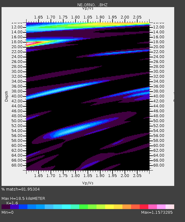
| Estimated Moho Depth: |
18.5 km |
| Estimated Crust Vp/Vs: |
1.60 |
| Assumed Crust Vp: |
6.419 km/s |
| Estimated Crust Vs: |
4.012 km/s |
| Estimated Crust Poisson's Ratio: |
0.18 |
|
| Radial Match: |
81.95304 % |
| Radial Bump: |
400 |
| Transverse Match: |
57.55583 % |
| Transverse Bump: |
400 |
| SOD ConfigId: |
626651 |
| Insert Time: |
2014-04-21 02:43:52.069 +0000 |
| GWidth: |
2.5 |
| Max Bumps: |
400 |
| Tol: |
0.001 |
|

Signal To Noise
| Channel | StoN | STA | LTA |
| NE:ORNO: :BHZ:20140310T00:45:03.429987Z | 2.961374 | 1.0424857E-6 | 3.5202768E-7 |
| NE:ORNO: :BHN:20140310T00:45:03.429987Z | 1.9872009 | 5.0083486E-7 | 2.520303E-7 |
| NE:ORNO: :BHE:20140310T00:45:03.429987Z | 1.0478628 | 3.5844832E-7 | 3.4207562E-7 |
| Arrivals |
| Ps | 1.9 SECOND |
| PpPs | 6.9 SECOND |
| PsPs/PpSs | 8.8 SECOND |


